
Recomendados
Más contenido relacionado
Similar a 41.pptx
Similar a 41.pptx (20)
Último
Último (20)
41.pptx
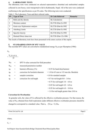
- 1. 4. LABORATORY TESTS The laboratory tests were conducted on selected representative disturbed and undisturbed samples collected in core boxes, were transported to lab in Kathmandu, Nepal. All of the tests were conducted confirming to the specifications as per IS codes. The following tests were conducted: Table 1: The Laboratory Tests and their referred codes. SN Type of Test IS Code Referred Remarks 1 Bulk and dry density By Calculations 2 Moisture content IS:2720 (Part-2)-1992 3 Grain size/ Hydrometer analysis IS:2720 (Part-4)-1992 4 Atterberg Limits IS:2720 (Part-5)-1992 5 Specific Gravity IS:2720 (Part-3)-1992 6 Drained Direct shear test IS:2720 (Part-13)-1986 The results of laboratory tests have been presented in the annex section of this report. 5. STANDARDIZATION OF SPT VALUE The recorded SPT values are converted to standardized energy N60 as per Skempton (1986): N60 N η η η η = rec H B S R 60 N60 = SPT N value corrected for field procedure Nrec = measured penetration number ηH = hammer efficiency (%) = 0.55 for hand drop hammer ηB = correction for borehole diameter = 1.0 for 65 mm to 115 mm dia. Borehole ηS = sampler correction =1.0 for standard sampler ηR = correction for rod length = 0.7 for rod length 0.0 – 3.0 m = 0.75 for rod length 3.0 – 4.0 m = 0.85 for rod length 4.0 – 6.0 m = 0.95 for rod length 6.0 – 10.0 m = 1.0 for rod length greater than 10.0 m Correction for Overburden: In granular soils, the value of N is affected by the effective overburden pressure. For that reason, the value of N60 obtained from field exploration under different effective overburden pressures should be changed to correspond to a standard value. That is, (N1)60 = CNN60 Prime Civil Lab Pvt. Ltd. Page 3 where, CN = Soil Report: Sano Kumale Khola Bridge Chulachuli Rural Municipality Illam
- 2. as per Liao and Whitman 1987 If Nrec ≤ 15, then Ncorr =Nrec Nrec ≥ Ncorr = ½(Nrec-15) Table 2: Correction of Field SPT values. 6. GENERAL GEOLOGY OF THE SITE Geologically, the proposed site area for the soil investigation lies in lower siwalik zone also called as Bhabar zone of Northern Terai that extends from the Indian Shield in the South to the Sub-Himalayan (Siwalik) Zone to the North. Terai Zone is a foreland basin and has sediment originated from peaks of Northern part. To the north, this zone is separated by an active thrust system called as the Main Frontal Thrust (MFT) with Siwalik. At some places along MFT, the Siwalik rocks are observed to rest over the recent sediments of the Terai (Dahal 2006). The Terai Zone has been further classified into Northern Terai or Bhabhar Zone, Middle Terai and Southern Terai. The proposed site lies in the Northern Terai or Bhabhar Zone. This zone is mainly composed of boulders, pebbles, cobbles and coarse sand derived from the rocks of Siwalik and Lesser Himalaya. These boulders, pebbles, and cobbles are mostly made up of sandstones (Fig 1.5) and the rocks from the immediate northern vicinity. Bhabhar Zone acts as a recharge zone for the groundwater of Terai. Most of the rivers lose their water while passing through this zone. In this Zone, water tables in wells show very sharp fluctuations between the summer and rainy seasons. At some places the wells Depth (m) Measured SPT Correction for (N1)60 Overburden Hammer efficiency Rod Length Borehole diameter Sampler Type BH1 BH2 BH1 BH2 1.5 m 10 12 1.7 0.75 1 0.75 1 10.20 11.90 3.0 m 14 14 1.7 0.75 1 0.75 1 13.60 13.60 4.5 m 18 17 1.7 0.75 1 0.85 1 18.70 18.70 6.0 m 20 30 1.57 0.75 1 0.85 1 19.41 29.67 7.5 m 23 29 1.4 0.75 1 0.95 1 21.05 28.19 9.0 m 24 34 1.28 0.75 1 0.95 1 20.84 29.82 10.5 m 31 29 1.18 0.75 1 1 1 27.05 25.19 12.0 m 36 32 1.11 0.75 1 1 1 28.96 24.92 13.5 m 43 29 1.04 0.75 1 1 1 32.86 22.01 15.0 m 31 32 0.99 0.75 1 1 1 21.27 22.41 16.0 m 31 32 0.99 0.75 1 1 1 21.28 22.41 Prime Civil Lab Pvt. Ltd. Page 4 σz ' Dilatancy Correction (for fine sand and silts below water table) Terzaghi and Peck (1976) gave correction for water pressure as,
- 3. Soil Report: Sano Kumale Khola Bridge Chulachuli Rural Municipality Illam become completely dry in summer. Due to the very course nature of the sediments, low water table and quick percolation of rainwater, this zone is particularly not productive for agriculture and therefore ideal for the development of forest resources. Figure 2: Simplified geological Map of Nepal Showing Drilling Site. Source: Shrestha et al. 1985,1986, 1987, ESCAP (1993), Amatya and Gyawali (1994) Figure 3: Physiographic division of Nepal. (Source: Modified from Hagen (1969). Prime Civil Lab Pvt. Ltd. Page 5 Soil Report: Sano Kumale Khola Bridge Chulachuli Rural Municipality Illam
- 4. 7. SEISMICITY AND LIQUEFACTION Figure 4: Probabilistic Seismic hazard of Nepal. Ground motion can be simply quantified by peak values of expectable acceleration, velocity and/or displacement. Empirical relationships, called attenuation equations, can be derived from the interpretation of available strong motion records and relate peak ground motion parameters to magnitude and distance from the source of energy release. Attenuation equations are sensitive to the estimates of distance and magnitude, especially in the near-field. Peak ground acceleration (PGA) often represents the main seismic evaluation parameter for simplified analysis purposes. The peak ground acceleration (usually as a fraction of the peak) is the earthquake ground motion parameter usually used in the seismic coefficient method of analysis. Attenuation model of Young’s et al (1997) for subduction zones for bed rock was used in development of seismic hazard map of Nepal. When fine or medium, saturated, loose sand deposit is subjected to a sudden shock (generated by an earthquake) the mass will densify and consolidate or temporarily liquefy. This phenomenon is termed 'Liquefaction'. Pore-water pressures within such layers increase as the soils are cyclically loaded, resulting in a decrease in vertical effective stress and shear strength. If the shear strength drops below the applied cyclic shear loadings, the layer is expected to transition to a semi fluid state until the excess pore-water pressure dissipates. When liquefaction takes place in a particular soil then the bearing capacity of the soil disappears and the structure built on it gets tilts or even sinks. The past big earthquakes, have shown that saturated sandy soils in a loose to medium dense condition were liquefied during earthquakes varying in magnitude from 5.5 to 8.5 (Richter scale) and epicenter distance from several miles to hundreds of miles. Prime Civil Lab Pvt. Ltd. Page 6 Soil Report: Sano Kumale Khola Bridge Chulachuli Rural Municipality Illam
- 5. Analysis of Liquefaction The stress-based approach for evaluating the potential for liquefaction triggering, initiated by Seed and Idriss (1967), compares the earthquake-induced cyclic stress ratios (CSR) with the cyclic resistance ratios (CRR) of the soil. The soil's CRR is usually correlated to an in-situ parameter SPT blow count. Factor of safety is evaluated as, 𝐶𝐶𝐶𝐶𝐶𝐶7.5 𝐹 𝐹 𝐹 𝐹 𝐹 𝐹= 𝐶𝐶𝐹𝐹𝐶𝐶7.5,𝜎𝜎 where, CRR7.5 CSR7.5,σ = Cyclic Resistance Ratio for earthquake of magnitude 7.5 = normalized cyclic stress ratio for earthquakes of magnitude 7.5 and effective overburden pressure of 100kPa. 𝜎 𝜎 𝑣 𝑣𝑎 𝑎 𝑚 𝑚 𝑎 𝑎 𝑚 𝑚 𝑟𝑟𝑑 𝑑 1 𝐶𝐶𝐹𝐹𝐶𝐶7 . 5 , 𝜎 𝜎 = 0.65 𝜎𝜎′ 𝑔 𝑔 𝑀 𝑀 𝐹 𝐹 𝐹 𝐹𝐾 𝐾 𝜎 𝜎 where, σv = σ’v = amax/g = rd = 𝑣𝑣 the total vertical sress at depth z the effective vertical sress at depth z maximum horizontal acceleration (as fraction of gravity) at ground surface, shear stress reduction factor that accounts for the dynamic response of the soil. 𝑟 𝑟 𝑑 𝑑 = 𝑒 𝑒 𝑚 𝑚 𝑒 𝑒 [ 𝛼 𝛼 ( 𝑧 𝑧 )+ 𝛽𝛽(𝑧𝑧).𝑀 𝑀 ] 𝑧 𝑧 𝛼𝛼(𝑧𝑧)= −1.012 − 1.126𝑠𝑠𝑠𝑠𝑠𝑠( + 5.133) 𝛽𝛽(𝑧𝑧)= 0.106 + 0.118𝑠𝑠𝑠𝑠𝑠𝑠( 11.73 𝑧 𝑧 + 5.142) 11.28 − 𝑀 𝑀 MSF= magnitude scaling factor = 6 . 9 𝑒 𝑒 𝑚 𝑚 𝑒 𝑒( ) − 0.058 ≤ 1.8 for sands 4 − 𝑀 𝑀 = 1 .1 2 𝑒𝑒𝑚𝑚𝑒𝑒( 4 ) + .828 ≤ 1.13 for clays
- 6. Kσ = overburden correction factor = 1 − 𝐶 𝐶 𝜎𝜎 𝜎𝜎′ 𝑙 𝑙 𝑣𝑣 𝑠𝑠 ) ≤ 1.1 ( 𝑃𝑃𝑎 𝑎 1 𝐶 𝐶 𝜎 𝜎 = ≤ 0.3 18.9 − 2.55√(𝑁𝑁1)60𝑐𝑐𝑠𝑠) (𝑁𝑁1)60𝑐𝑐𝑠𝑠 = (𝑁𝑁1)60 + ∆(𝑁𝑁1)60 9.7 ∆(𝑁𝑁1)60 = 𝑒 𝑒 𝑚 𝑚 𝑒 𝑒(1.63 + − ( 𝐹 𝐹 𝐶 𝐶+ 0.01 15.7 2 ) ) 𝐹 𝐹 𝐶 𝐶+ 0.01 Cyclic resistance ratio (CRR), the capacity of soil to resist liquefaction, can be obtained from the corrected blow count and soil’s fine content. 𝐶𝐶𝐶𝐶𝐶𝐶7 . 5 , 1 𝑎 𝑎 𝑎 𝑎 𝑚 𝑚 = 𝑓𝑓[(𝑁𝑁1)60), 𝐹 𝐹 𝐶 𝐶 ] 𝐶 𝐶 𝐶 𝐶 𝐶 𝐶 = exp ( (𝑁𝑁1) 60𝑐𝑐𝑠𝑠 (𝑁𝑁1) + ( 2 60𝑐𝑐𝑠𝑠 ) (𝑁𝑁1) − ( 3 60𝑐𝑐𝑠𝑠 ) (𝑁𝑁1) + ( 4 60𝑐𝑐𝑠𝑠 ) − 2.8) 7.5,1𝑎𝑎𝑎𝑎𝑚𝑚 14.1 126 23.6 25.4
- 7. Prime Civil Lab Pvt. Ltd. Page 7 Soil Report: Sano Kumale Khola Bridge Chulachuli Rural Municipality Illam Liquefaction potential index (LPI) is a single-valued parameter to evaluate regional liquefaction