SlideShare una empresa de Scribd logo
1 de 23
Descargar para leer sin conexión
Mgr. Petr Přidal - Klokan
CZECH TECHNICAL UNIVERSITY IN PRAGUE                                                     MASARYK UNIVERSITY
Geodesy & Cartography                                                                      Applied Informatics


                                                 klokan@klokan.cz


                                       MAPTILER:
              MAP PUBLISHING A LA GOOGLE MAPS

                                   Moravian Library Brno: OldMapsOnline.org
                           R&D grant of the Czech Ministry of Culture (DC08P02OUK006)

                                          European Library Automation Group: ELAG 2009
                                             Bratislava, Slovakia - 22 – 24 April 2009
MAPTILER - WHAT IS IT?


• MapTiler is an easy to use graphical application for
  online map publishing
• You need to georeference your scanned maps! Usually in
  GIS software (ESRI ArcGIS, MapInfo, ... Grass, QGis, ...)
• MapTiler can transform coordinate systems and
  correctly warp existing map projections
• A simple web viewer (OpenLayers, Google Maps API) and
  KML files (Google Earth, indexing) are directly generated
• Standards: OSGEO TMS + OGC WMTS, WMS by proxy
STANDALONE MAP DEMO
GOOGLE MAPS OVERLAY DEMO
OPENLAYERS DEMO
GOOGLE EARTH DEMO
Who are users of MapTiler / GDAL2Tiles?
        National Library of Scotland, NOAA, BRGM, US Forest Survey, ...
Companies from: USA (including Google Inc.), New Zealand, Italy, France, UK, Chile...

          MapTiler development was supported by:
                   Google Inc. : Summer of code 2007, 2008
                           NIC.CZ: VIP competition
             BRGM (Bureau des Recherches Geologiques et Minières)

          Thanks to Czech Technical University in Prague - prof. Veverka


                 MAPTILER - MAP TILE MASHUPS
                        Available for download for free NOW!
                      Standard Windows installer (setup.exe).
           User support in the user group with archive and fulltext search.

    Possible commercial support, automation and customization for your project.

                               www.maptiler.org
                           www.oldmapsonline.org

Más contenido relacionado

Similar a MapTiler lightning talk - ELAG 2009

CensusGIV - Geographic Information Visualisation of Census Data
CensusGIV - Geographic Information Visualisation of Census DataCensusGIV - Geographic Information Visualisation of Census Data
CensusGIV - Geographic Information Visualisation of Census Data
CASA, UCL
 
The British Library, London: Old Maps Online
The British Library,  London: Old Maps OnlineThe British Library,  London: Old Maps Online
The British Library, London: Old Maps Online
Petr Pridal
 
Brno FF MU KISK Blok expertu
Brno FF MU KISK Blok expertuBrno FF MU KISK Blok expertu
Brno FF MU KISK Blok expertu
Petr Pridal
 

Similar a MapTiler lightning talk - ELAG 2009 (14)

CartoHeritage 2011: Georeferencer & MapRank Search
CartoHeritage 2011: Georeferencer & MapRank SearchCartoHeritage 2011: Georeferencer & MapRank Search
CartoHeritage 2011: Georeferencer & MapRank Search
 
GIS and Map Tiles
GIS and Map TilesGIS and Map Tiles
GIS and Map Tiles
 
Network Based Kernel Density Estimation for Cycling Facilities Optimal Locati...
Network Based Kernel Density Estimation for Cycling Facilities Optimal Locati...Network Based Kernel Density Estimation for Cycling Facilities Optimal Locati...
Network Based Kernel Density Estimation for Cycling Facilities Optimal Locati...
 
Network Based Kernel Density Estimation for Cycling Facilities Optimal Locati...
Network Based Kernel Density Estimation for Cycling Facilities Optimal Locati...Network Based Kernel Density Estimation for Cycling Facilities Optimal Locati...
Network Based Kernel Density Estimation for Cycling Facilities Optimal Locati...
 
CensusGIV - Geographic Information Visualisation of Census Data
CensusGIV - Geographic Information Visualisation of Census DataCensusGIV - Geographic Information Visualisation of Census Data
CensusGIV - Geographic Information Visualisation of Census Data
 
The British Library, London: Old Maps Online
The British Library,  London: Old Maps OnlineThe British Library,  London: Old Maps Online
The British Library, London: Old Maps Online
 
'Cultural Heritage under Lenses: 3D Icons Project and the Romanian experience...
'Cultural Heritage under Lenses: 3D Icons Project and the Romanian experience...'Cultural Heritage under Lenses: 3D Icons Project and the Romanian experience...
'Cultural Heritage under Lenses: 3D Icons Project and the Romanian experience...
 
ORFEO ToolBox at CS-SI From research to operational applications
ORFEO ToolBox at CS-SI From research to operational applicationsORFEO ToolBox at CS-SI From research to operational applications
ORFEO ToolBox at CS-SI From research to operational applications
 
The FOCUS K3D Project
The FOCUS K3D ProjectThe FOCUS K3D Project
The FOCUS K3D Project
 
Paszto - Fractal dimension of the Czech road network
Paszto - Fractal dimension of the Czech road networkPaszto - Fractal dimension of the Czech road network
Paszto - Fractal dimension of the Czech road network
 
CV HR2022.pdf
CV HR2022.pdfCV HR2022.pdf
CV HR2022.pdf
 
Czech Republic: ARIADNE - Success stories from partners and the research comm...
Czech Republic: ARIADNE - Success stories from partners and the research comm...Czech Republic: ARIADNE - Success stories from partners and the research comm...
Czech Republic: ARIADNE - Success stories from partners and the research comm...
 
Brno FF MU KISK Blok expertu
Brno FF MU KISK Blok expertuBrno FF MU KISK Blok expertu
Brno FF MU KISK Blok expertu
 
Spatial is Not Special ?
Spatial is Not Special ?Spatial is Not Special ?
Spatial is Not Special ?
 

Último

Architecting Cloud Native Applications
Architecting Cloud Native ApplicationsArchitecting Cloud Native Applications
Architecting Cloud Native Applications
WSO2
 
Cloud Frontiers: A Deep Dive into Serverless Spatial Data and FME
Cloud Frontiers:  A Deep Dive into Serverless Spatial Data and FMECloud Frontiers:  A Deep Dive into Serverless Spatial Data and FME
Cloud Frontiers: A Deep Dive into Serverless Spatial Data and FME
Safe Software
 

Último (20)

Powerful Google developer tools for immediate impact! (2023-24 C)
Powerful Google developer tools for immediate impact! (2023-24 C)Powerful Google developer tools for immediate impact! (2023-24 C)
Powerful Google developer tools for immediate impact! (2023-24 C)
 
Apidays New York 2024 - Scaling API-first by Ian Reasor and Radu Cotescu, Adobe
Apidays New York 2024 - Scaling API-first by Ian Reasor and Radu Cotescu, AdobeApidays New York 2024 - Scaling API-first by Ian Reasor and Radu Cotescu, Adobe
Apidays New York 2024 - Scaling API-first by Ian Reasor and Radu Cotescu, Adobe
 
GenAI Risks & Security Meetup 01052024.pdf
GenAI Risks & Security Meetup 01052024.pdfGenAI Risks & Security Meetup 01052024.pdf
GenAI Risks & Security Meetup 01052024.pdf
 
Strategize a Smooth Tenant-to-tenant Migration and Copilot Takeoff
Strategize a Smooth Tenant-to-tenant Migration and Copilot TakeoffStrategize a Smooth Tenant-to-tenant Migration and Copilot Takeoff
Strategize a Smooth Tenant-to-tenant Migration and Copilot Takeoff
 
AXA XL - Insurer Innovation Award Americas 2024
AXA XL - Insurer Innovation Award Americas 2024AXA XL - Insurer Innovation Award Americas 2024
AXA XL - Insurer Innovation Award Americas 2024
 
TrustArc Webinar - Unlock the Power of AI-Driven Data Discovery
TrustArc Webinar - Unlock the Power of AI-Driven Data DiscoveryTrustArc Webinar - Unlock the Power of AI-Driven Data Discovery
TrustArc Webinar - Unlock the Power of AI-Driven Data Discovery
 
AWS Community Day CPH - Three problems of Terraform
AWS Community Day CPH - Three problems of TerraformAWS Community Day CPH - Three problems of Terraform
AWS Community Day CPH - Three problems of Terraform
 
Navi Mumbai Call Girls 🥰 8617370543 Service Offer VIP Hot Model
Navi Mumbai Call Girls 🥰 8617370543 Service Offer VIP Hot ModelNavi Mumbai Call Girls 🥰 8617370543 Service Offer VIP Hot Model
Navi Mumbai Call Girls 🥰 8617370543 Service Offer VIP Hot Model
 
Automating Google Workspace (GWS) & more with Apps Script
Automating Google Workspace (GWS) & more with Apps ScriptAutomating Google Workspace (GWS) & more with Apps Script
Automating Google Workspace (GWS) & more with Apps Script
 
A Beginners Guide to Building a RAG App Using Open Source Milvus
A Beginners Guide to Building a RAG App Using Open Source MilvusA Beginners Guide to Building a RAG App Using Open Source Milvus
A Beginners Guide to Building a RAG App Using Open Source Milvus
 
MS Copilot expands with MS Graph connectors
MS Copilot expands with MS Graph connectorsMS Copilot expands with MS Graph connectors
MS Copilot expands with MS Graph connectors
 
Apidays Singapore 2024 - Building Digital Trust in a Digital Economy by Veron...
Apidays Singapore 2024 - Building Digital Trust in a Digital Economy by Veron...Apidays Singapore 2024 - Building Digital Trust in a Digital Economy by Veron...
Apidays Singapore 2024 - Building Digital Trust in a Digital Economy by Veron...
 
Architecting Cloud Native Applications
Architecting Cloud Native ApplicationsArchitecting Cloud Native Applications
Architecting Cloud Native Applications
 
Apidays Singapore 2024 - Modernizing Securities Finance by Madhu Subbu
Apidays Singapore 2024 - Modernizing Securities Finance by Madhu SubbuApidays Singapore 2024 - Modernizing Securities Finance by Madhu Subbu
Apidays Singapore 2024 - Modernizing Securities Finance by Madhu Subbu
 
Boost Fertility New Invention Ups Success Rates.pdf
Boost Fertility New Invention Ups Success Rates.pdfBoost Fertility New Invention Ups Success Rates.pdf
Boost Fertility New Invention Ups Success Rates.pdf
 
How to Troubleshoot Apps for the Modern Connected Worker
How to Troubleshoot Apps for the Modern Connected WorkerHow to Troubleshoot Apps for the Modern Connected Worker
How to Troubleshoot Apps for the Modern Connected Worker
 
EMPOWERMENT TECHNOLOGY GRADE 11 QUARTER 2 REVIEWER
EMPOWERMENT TECHNOLOGY GRADE 11 QUARTER 2 REVIEWEREMPOWERMENT TECHNOLOGY GRADE 11 QUARTER 2 REVIEWER
EMPOWERMENT TECHNOLOGY GRADE 11 QUARTER 2 REVIEWER
 
Emergent Methods: Multi-lingual narrative tracking in the news - real-time ex...
Emergent Methods: Multi-lingual narrative tracking in the news - real-time ex...Emergent Methods: Multi-lingual narrative tracking in the news - real-time ex...
Emergent Methods: Multi-lingual narrative tracking in the news - real-time ex...
 
Artificial Intelligence Chap.5 : Uncertainty
Artificial Intelligence Chap.5 : UncertaintyArtificial Intelligence Chap.5 : Uncertainty
Artificial Intelligence Chap.5 : Uncertainty
 
Cloud Frontiers: A Deep Dive into Serverless Spatial Data and FME
Cloud Frontiers:  A Deep Dive into Serverless Spatial Data and FMECloud Frontiers:  A Deep Dive into Serverless Spatial Data and FME
Cloud Frontiers: A Deep Dive into Serverless Spatial Data and FME
 

MapTiler lightning talk - ELAG 2009

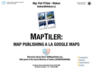
  • 1. Mgr. Petr Přidal - Klokan CZECH TECHNICAL UNIVERSITY IN PRAGUE MASARYK UNIVERSITY Geodesy & Cartography Applied Informatics klokan@klokan.cz MAPTILER: MAP PUBLISHING A LA GOOGLE MAPS Moravian Library Brno: OldMapsOnline.org R&D grant of the Czech Ministry of Culture (DC08P02OUK006) European Library Automation Group: ELAG 2009 Bratislava, Slovakia - 22 – 24 April 2009
  • 2. MAPTILER - WHAT IS IT? • MapTiler is an easy to use graphical application for online map publishing • You need to georeference your scanned maps! Usually in GIS software (ESRI ArcGIS, MapInfo, ... Grass, QGis, ...) • MapTiler can transform coordinate systems and correctly warp existing map projections • A simple web viewer (OpenLayers, Google Maps API) and KML files (Google Earth, indexing) are directly generated • Standards: OSGEO TMS + OGC WMTS, WMS by proxy
  • 6.
  • 7.
  • 9.
  • 10.
  • 11.
  • 12.
  • 13.
  • 14.
  • 15.
  • 16.
  • 17.
  • 18.
  • 19.
  • 20.
  • 21.
  • 22.
  • 23. Who are users of MapTiler / GDAL2Tiles? National Library of Scotland, NOAA, BRGM, US Forest Survey, ... Companies from: USA (including Google Inc.), New Zealand, Italy, France, UK, Chile... MapTiler development was supported by: Google Inc. : Summer of code 2007, 2008 NIC.CZ: VIP competition BRGM (Bureau des Recherches Geologiques et Minières) Thanks to Czech Technical University in Prague - prof. Veverka MAPTILER - MAP TILE MASHUPS Available for download for free NOW! Standard Windows installer (setup.exe). User support in the user group with archive and fulltext search. Possible commercial support, automation and customization for your project. www.maptiler.org www.oldmapsonline.org