VK 2pager
•
0 recomendaciones•327 vistas

Always wanted to know more about Virtual Kenya http://virtualkenya.org... read the 2 pager and you know!

Recomendados
Recomendados
Más contenido relacionado
Destacado
Destacado (20)
Similar a VK 2pager
Similar a VK 2pager (20)
Último
Último (20)
VK 2pager
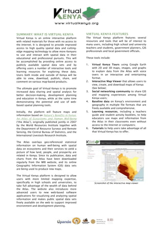
- 1. SUMMARY: WHAT IS VIRTUAL KENYA VIRTUAL KENYA FEATURES Virtual Kenya is an online interactive platform The Virtual Kenya platform features several with related materials for those with no access to resources and tools that will be of interest to the Internet. It is designed to provide improved many users, including high school and university access to high quality spatial data and cutting- teachers and students, government planners, GIS edge mapping technology to allow more Kenyans professionals and local government officials. to use and interact with spatial data in their educational and professional pursuits. This will These tools include: be accomplished by providing online access to publicly available spatial data sets and by 1. Virtual Kenya Tours using Google Earth offering users a number of interactive tools and with 2D and 3D maps, images, and graphs learning resources for exploring these data. to explain data from the Atlas with voice Users both inside and outside of Kenya will be overs in an interactive and entertaining able to view, download, publish, share, and format. comment on various map-based products. 2. Interactive Map Viewer that allows users to view, create, and download maps of Kenya The ultimate goal of Virtual Kenya is to promote (See below); increased data sharing and spatial analysis for 3. Social networking community to share GIS better decision-making, development planning and mapping experiences among Virtual and education in Kenya, while at the same time Kenya users; demonstrating the potential and use of web- 4. Baseline data on Kenya's environment and based spatial planning tools. geography in multiple file formats that are freely available and comprehensive; Initially, the platform will feature maps and 5. Learning resources, including a teachers information based on Nature’s Benefits in Kenya: guide and student activity booklets, to help An Atlas of Ecosystems and Human Well-Being educators use maps and information from (“the Atlas”), originally published jointly in 2007 the Atlas in their classrooms even without by the World Resources Institute together with access to the Internet or computers; the Department of Resource Surveys and Remote 6. Tutorials to help users take advantage of all Sensing, the Central Bureau of Statistics, and the that Virtual Kenya has to offer. International Livestock Research Institute. The Atlas overlays geo-referenced statistical information on human well-being with spatial data on ecosystems and their services to yield a picture of how land, people, and prosperity are related in Kenya. Since its publication, data and charts from the Atlas have been downloaded regularly from the WRI website, and its online Geographic Information System (GIS) data sets are being used to produce new maps. The Virtual Kenya platform is designed to allow users with more limited mapping expertise, specifically in high schools and universities, to Screenshot of the interactive map viewer take full advantage of the wealth of data behind the Atlas. The website also introduces more advanced users to new web-based software applications for visualizing and analyzing spatial information and makes public spatial data sets freely available on the web to support improved environment and development planning.
- 2. WHO SHOULD USE VIRTUAL KENYA HOW YOU CAN GET INVOLVED Target audiences of the website include students To get involved, you can log in to the website and teachers at the secondary and tertiary level, and create your own account to view, download, GIS professionals, policy makers, government publish, share, and comment on maps and other planners, and local government officials. spatial data. Or you can simply watch a Virtual However, Virtual Kenya will be accessible to Kenya Tour to learn more about Kenya’s anyone interested in interactive maps about environment and geography and increase your Kenya and the matters relevant to the daily lives spatial skills. The site also offers users a social of Kenyans. networking opportunity to discuss topics related to GIS and other spatial information available within or outside Virtual Kenya. You can even win great prizes by entering online competitions to publish your own maps. The Virtual Kenya partners will also be organizing training events across Kenya to allow both online and offline users to interact with the tools, data, and learning resources featured on the website. PARTNERS Virtual Kenya is a collaborative project by Upande Ltd. and the World Resources Institute. Some of the content was developed together with the Wildlife Clubs of Kenya, Jacaranda Designs Ltd., Screenshot of the homepage of the platform and the International Livestock Research Institute. Technical support was provided by Danida, Royal Danish Embassy as part of the WHY IS VIRTUAL KENYA INNOVATIVE Environment Programme Support in Kenya The Virtual Kenya website provides users with a funded by Danida and Sida. platform to interactively view, explore, and download Atlas data in a variety of file formats Most of the maps and information presented on and software applications, including Virtual Virtual Kenya were first published in Nature’s Kenya Tours using Google Earth. In addition, GIS Benefits in Kenya: An Atlas of Ecosystems and users in Kenya will—for the first time—have a Human Well-Being, funded by the Swedish dedicated online social networking community to International Development Agency; Irish Aid, share their work, comment and interact with Department of Foreign Affairs; Netherlands each other on topics related to maps and other Ministry of Foreign Affairs; United States Agency spatial data. for International Development; International Livestock Research Institute and Danish For those with limited mapping and GIS International Development Agency, Ministry of experience, Virtual Kenya will increase awareness Foreign Affairs. of resources and tools available online to visualize and explore spatial information. For users and classrooms that do not have access to CONTACT US the Internet yet, other materials—such as wall For further information about the Virtual Kenya charts, student activity booklets, a teachers website or related learning resources, please guide, as well as a DVD with all the Virtual Kenya contact us: data and software—will be available, giving them Email: info@virtualkenya.org the opportunity to interact with tools available on Phone: +254 774 162 071 the Virtual Kenya website. These resources can Website: http:/virtualkenya.org also be used to increase student comprehension Twitter: @virtualkenya of Atlas topics covered in the National Facebook: VirtualKenya Curriculum. LinkedIn: http://lnkd.in/dcr6aK YouTube: http://youtube.com/user/VirtualKenya