Spatial analysis of topography and river watershed factors for leptospirosis cases in Kulon Progo, Yogyakarta Province, Indonesia
•
0 recomendaciones•1,439 vistas

Poster by Dyah Ayu Widiasih, Wayan T. Artama, Adi Heru Husodo, Tjut Sugandawaty Djohan and Fred Unger presented at the Ecohealth 2014 conference, Montreal, Canada, 11-15 August 2014.

Recomendados
Más contenido relacionado
Destacado
Destacado (20)
Similar a Spatial analysis of topography and river watershed factors for leptospirosis cases in Kulon Progo, Yogyakarta Province, Indonesia
Similar a Spatial analysis of topography and river watershed factors for leptospirosis cases in Kulon Progo, Yogyakarta Province, Indonesia (20)
Más de ILRI
Más de ILRI (20)
Último
Último (20)
Spatial analysis of topography and river watershed factors for leptospirosis cases in Kulon Progo, Yogyakarta Province, Indonesia
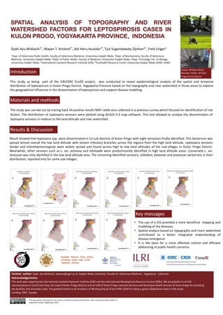
- 1. SPATIAL ANALYSIS OF TOPOGRAPHY AND RIVER WATERSHED FACTORS FOR LEPTOSPIROSIS CASES IN KULON PROGO, YOGYAKARTA PROVINCE, INDONESIA Dyah Ayu Widiasih1*, Wayan T. Artama2*, Adi Heru Husodo3*, Tjut Sugandawaty Djohan4*, Fred Unger5 1Dept. of Veterinary Public Health, Faculty of Veterinary Medicine, Universitas Gadjah Mada, 2Dept. of Biochemistry, Faculty of Veterinary Medicine, Universitas Gadjah Mada, 3Dept. of Public Health, Faculty of Medicine, Universitas Gadjah Mada, 4Dept. of Ecology, Fac. of Biology, Universitas Gadjah Mada, 5International Livestock Research Institute (ILRI), *EcoHealth Resource Center‐Universitas Gadjah Mada (EHRC‐UGM) Introduction Source: Widodo (2012), Muniipal Health of Kulon Progo District (2011) This study, as being part of the ILRI/IDRC EcoZD project, was conducted to reveal epidemiological analysis of the spatial and temporal distribution of leptospirosis in Kulon Progo District, Yogyakarta Province based on the topography and river watershed in those areas to explore the geographical influences in the dissemination of leptospirosis and support disease modeling. Materials and methods The study was carried out by tracing back 54 positive results MAT cattle sera collected in a previous survey which focused on identification of risk factors. The distribution of Leptospira serovars were plotted using ArcGIS 9.3 map software. This tool allowed to analyze the dissemination of leptospira serovars in relation to the land altitude and river watershed. Results & Discussion Result showed that leptospira spp. were disseminated in 12 sub‐districts of Kulon Progo with eight serovares finally identified. This bacterium was spread almost overall the low land altitude with stream tributary branches across the regions from the high land altitude. Leptospira serovars hardjo and icterohaemorragicae were widely spread and found across high to low land altitudes of the sub‐villages in Kulon Progo District. Meanwhile, other serovars such as L. ser. pomona and rahmadie were predominantly identified in high land altitude areas. Conversely L. ser. tarassovi was only identified in the low land altitude area. The remaining identified serovars, celledoni, bataviae and javanicae varied less in their distribution, reported only for some sub‐villages. Contact author: Dyah Ayu Widiasih; dyahaw@ugm.ac.id, Gadjah Mada University, Faculty for Veterinary Medicine , Yogyakarta, Indonesia Acknowledgements: This work was supported by International Livestock Research Institute (ILRI) and the International Development Resource Centre (IDRC). We are grateful to all ILRI representatives in South East Asia, the head of Kulon Progo districts and all staff of Kulon Progo Livestock Services and Municipal Health Services of Kulon Progo for providing the facilities and secondary data. The grateful thanks to all members of Working Group of the EHRC‐UGM for being a good collaborative team in this study. Funding: IDRC Canada This document is licensed for use under a Creative Commons Attribution –Non commercial‐Share Alike 3.0 Unported License September 2014 Key messages • The use of a GIS provided a more beneficial mapping and modeling of the diseases. • Spatial analysis based on topography and rivers watershed contributed to a better integrated understanding of disease emergence • It is the basis for a more effective control and efficient addressing of public health concerns.