Following linked data
•Descargar como PPTX, PDF•
1 recomendación•278 vistas

This document provides information to a forum user asking where to find data on which council areas border others in the UK. It recommends searching for open data on Central Bedfordshire council's area through their Open Data Communities page and Ordnance Survey data, and checking the local government information portal for additional details.
Denunciar
Compartir
Denunciar
Compartir
Recomendados
Cross-bordering implies taking into account a diverse range of factors between two regional hubs in the interest of comparing case studies. This paper contrasts two city-regional configurations: on the one hand, the Oresund city-region (or newly called Greater Copenhagen) between Copenhagen and Malmö; and on the other hand, the Basque Country between French Pays Basque, Navarra Statutory Autonomy and the Basque Autonomy. Both cases consist of two nation-states. In the case of Oresund, the city-region is configured between Sweden and Denmark. In the case of the Basque Country, the city-region is situated between Spain and France. Moreover, the two cases depict very diverse patterns of cross-bordering collaboration: in the Oresund city-region, the cooperation has been primarily fuelled by the two main cities; in the Basque city-region, although there are remarkable territorial synergies, there is not clear leadership between the three aforementioned territorial entities.'Comparing Cross-Bordering City-Regional Strategies Beyond Nation States in O...
'Comparing Cross-Bordering City-Regional Strategies Beyond Nation States in O...Dr Igor Calzada, MBA, FeRSA
Dr Igor Calzada will deliver a paper on 17th May 2016 entitled 'Comparing Cross-Bordering City-Regional Strategies Beyond Nation-States in Oresund and the Basque Country' in the session Cross-Border City and Regional Strategies in the conference BRIT 2016.15th Border Regions in Transition (BRIT) Conference 'Cities, States and Borde...
15th Border Regions in Transition (BRIT) Conference 'Cities, States and Borde...Dr Igor Calzada, MBA, FeRSA
Model Call Girl Services in Delhi reach out to us at 🔝 9953056974🔝✔️✔️ Our agency presents a selection of young, charming call girls available for bookings at Oyo Hotels. Experience high-class escort services at pocket-friendly rates, with our female escorts exuding both beauty and a delightful personality, ready to meet your desires. Whether it's Housewives, College girls, Russian girls, Muslim girls, or any other preference, we offer a diverse range of options to cater to your tastes. We provide both in- call and out-call services for your convenience. Our in-call location in Delhi ensures cleanliness, hygiene, and 100% safety, while our out-call services offer doorstep delivery for added ease. We value your time and money, hence we kindly request pic collectors, time-passers, and bargain hunters to refrain from contacting us. Our services feature various packages at competitive rates: One shot: ₹2000/in-call, ₹5000/out-call Two shots with one girl: ₹3500 /in-call, ₱6000/out-call Body to body massage with sex: ₱3000/in-call Full night for one person: ₱7000/in-call, ₱10000/out-call Full night for more than 1 person : Contact us at 🔝 9953056974🔝. for details Operating 24/7, we serve various locations in Delhi, including Green Park, Lajpat Nagar, Saket, and Hauz Khas near metro stations. For premium call girl services in Delhi 🔝 9953056974🔝. Thank you for considering us call girls in Anand Vihar (delhi) call me [🔝9953056974🔝] escort service 24X7
call girls in Anand Vihar (delhi) call me [🔝9953056974🔝] escort service 24X79953056974 Low Rate Call Girls In Saket, Delhi NCR
Más contenido relacionado
Último
Model Call Girl Services in Delhi reach out to us at 🔝 9953056974🔝✔️✔️ Our agency presents a selection of young, charming call girls available for bookings at Oyo Hotels. Experience high-class escort services at pocket-friendly rates, with our female escorts exuding both beauty and a delightful personality, ready to meet your desires. Whether it's Housewives, College girls, Russian girls, Muslim girls, or any other preference, we offer a diverse range of options to cater to your tastes. We provide both in- call and out-call services for your convenience. Our in-call location in Delhi ensures cleanliness, hygiene, and 100% safety, while our out-call services offer doorstep delivery for added ease. We value your time and money, hence we kindly request pic collectors, time-passers, and bargain hunters to refrain from contacting us. Our services feature various packages at competitive rates: One shot: ₹2000/in-call, ₹5000/out-call Two shots with one girl: ₹3500 /in-call, ₱6000/out-call Body to body massage with sex: ₱3000/in-call Full night for one person: ₱7000/in-call, ₱10000/out-call Full night for more than 1 person : Contact us at 🔝 9953056974🔝. for details Operating 24/7, we serve various locations in Delhi, including Green Park, Lajpat Nagar, Saket, and Hauz Khas near metro stations. For premium call girl services in Delhi 🔝 9953056974🔝. Thank you for considering us call girls in Anand Vihar (delhi) call me [🔝9953056974🔝] escort service 24X7
call girls in Anand Vihar (delhi) call me [🔝9953056974🔝] escort service 24X79953056974 Low Rate Call Girls In Saket, Delhi NCR
Último (20)
Vip Firozabad Phone 8250092165 Escorts Service At 6k To 30k Along With Ac Room
Vip Firozabad Phone 8250092165 Escorts Service At 6k To 30k Along With Ac Room
call girls in Anand Vihar (delhi) call me [🔝9953056974🔝] escort service 24X7
call girls in Anand Vihar (delhi) call me [🔝9953056974🔝] escort service 24X7
20240509 QFM015 Engineering Leadership Reading List April 2024.pdf
20240509 QFM015 Engineering Leadership Reading List April 2024.pdf
"Boost Your Digital Presence: Partner with a Leading SEO Agency"
"Boost Your Digital Presence: Partner with a Leading SEO Agency"
20240507 QFM013 Machine Intelligence Reading List April 2024.pdf
20240507 QFM013 Machine Intelligence Reading List April 2024.pdf
Ballia Escorts Service Girl ^ 9332606886, WhatsApp Anytime Ballia
Ballia Escorts Service Girl ^ 9332606886, WhatsApp Anytime Ballia
Top profile Call Girls In Dindigul [ 7014168258 ] Call Me For Genuine Models ...
Top profile Call Girls In Dindigul [ 7014168258 ] Call Me For Genuine Models ...
Call girls Service in Ajman 0505086370 Ajman call girls
Call girls Service in Ajman 0505086370 Ajman call girls
APNIC Policy Roundup, presented by Sunny Chendi at the 5th ICANN APAC-TWNIC E...
APNIC Policy Roundup, presented by Sunny Chendi at the 5th ICANN APAC-TWNIC E...
Abu Dhabi Escorts Service 0508644382 Escorts in Abu Dhabi
Abu Dhabi Escorts Service 0508644382 Escorts in Abu Dhabi
Indian Escort in Abu DHabi 0508644382 Abu Dhabi Escorts
Indian Escort in Abu DHabi 0508644382 Abu Dhabi Escorts
Best SEO Services Company in Dallas | Best SEO Agency Dallas
Best SEO Services Company in Dallas | Best SEO Agency Dallas
Destacado
Destacado (20)
Product Design Trends in 2024 | Teenage Engineerings
Product Design Trends in 2024 | Teenage Engineerings
How Race, Age and Gender Shape Attitudes Towards Mental Health
How Race, Age and Gender Shape Attitudes Towards Mental Health
AI Trends in Creative Operations 2024 by Artwork Flow.pdf
AI Trends in Creative Operations 2024 by Artwork Flow.pdf
Content Methodology: A Best Practices Report (Webinar)
Content Methodology: A Best Practices Report (Webinar)
How to Prepare For a Successful Job Search for 2024
How to Prepare For a Successful Job Search for 2024
Social Media Marketing Trends 2024 // The Global Indie Insights
Social Media Marketing Trends 2024 // The Global Indie Insights
Trends In Paid Search: Navigating The Digital Landscape In 2024
Trends In Paid Search: Navigating The Digital Landscape In 2024
5 Public speaking tips from TED - Visualized summary
5 Public speaking tips from TED - Visualized summary
Google's Just Not That Into You: Understanding Core Updates & Search Intent
Google's Just Not That Into You: Understanding Core Updates & Search Intent
The six step guide to practical project management
The six step guide to practical project management
Beginners Guide to TikTok for Search - Rachel Pearson - We are Tilt __ Bright...
Beginners Guide to TikTok for Search - Rachel Pearson - We are Tilt __ Bright...
Following linked data
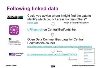
- 1. Following linked data Could you advise where I might find the data to identify which council areas borders others? Forum post Peter, Central Bedfordshire URI search on Central Bedfordshire Open Data Communities page for Central Bedfordshire council http://opendatacommunities.org/id/unitary-authority/central-bedfordshire governs http://data.ordnancesurvey.co.uk/id/7000000000043870 @MikeThacker www.local.gov.uk/lginformplus
Notas del editor
- Here’s a simple illustration of how a query can be answered by linked data AND one reason why using URIs can be powerful. Peter from Central Bedfordshire asked how he could identify the geographical neighbours of each council. As an example, I looks up Central Bedfordshire in ESD’s URI search page: http://uris.opendata.esd.org.uk/ That lead me to DCLG’s Open Data Communities page for the the council’s URI That gave me the Ordnance Survey URI of the area “governed” by Central Bedfordshire council That showed me the areas which Central Bedfordshire “touches” From there Peter could go on to check the type of area/council for each touching area if he wished to limit his geographic neighbours to top or second tier councils. All of that is machine readable as well as being accessible via web pages.