
Recomendados
Más contenido relacionado
La actualidad más candente
La actualidad más candente (20)
Destacado
Similar a Unit 9: Spanish coast relief
Similar a Unit 9: Spanish coast relief (20)
Más de nuriasanchez3
Más de nuriasanchez3 (20)
Último
Último (20)
Unit 9: Spanish coast relief
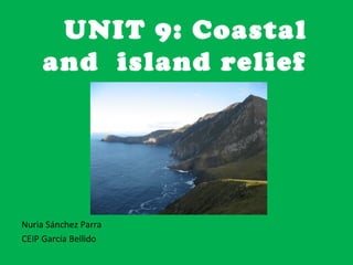
- 1. UNIT 9: Coastal and island relief Nuria Sánchez Parra CEIP García Bellido
- 2. Vocabulary • according … de acuerdo a • albuferas ….albuferas • alternates ….alterna • archipelago…archipiélago • bays…bahías • belong ….pertenecer • capes …cabos • cliffs…. acantilados • coastal …costera • deep … porfundo • deltas … deltas • extensive… extenso • gulfs … golfos • high…alto • highest …. el más alto • island …isla • islets….islote • lagoons….lagunas • land … tierra • low … bajo • lower …más bajo • main ….principal • mention … …mencionar • mount … monte • mouth …desembocadura • narrow … estrecho • northwest… noroeste • origin… origen • peak … pico ( montañoso) • peninsular … peninsular • relief… relieve • rias …rías • rising … cayendo • rocky … rocoso • salty …salado • sandy ….. arenoso • southwest…suroeste • surrounded ….rodeado • volcanic …volcánico • washed… bañado
- 3. Coastal relief On the coast, beaches can be formed, which are low and sandy areas, and cliffs, that are rocky areas rising vertical over the sea.
- 5. • There are different types of coastal relief: Capes Gulfs
- 7. • Capes are portions of land that come into the sea.
- 8. Deltas are also portions of land that come into the mouth of some rivers by the accumulation of materials that rivers transport.
- 9. • Gulfs are portions of sea that come into the land. If they are small, they are called bays..
- 10. Rias are deep and narrow portions of the sea, that come into the mouth of a river.
- 11. • Albuferas are salty lagoons that form on the coast
- 12. Activity • Match • Capes • Gulf • Albuferas • Deltas • Bays • Rias • Portion of sea that come into the land • Portion of land that come into the sea • Salty lagoons at the coast • Deep and narrow portion of sea, into the mouth of a river • Small portions of sea that come into the land • Portions of land that come into the mouth of a river
- 13. Spanish peninsular coasts Spanish coast is very extensive. It is surrounded by the Atlantic Ocean, the Mediterranean Sea and the Cantabrian Sea.
- 14. • The Atlantic coast is divided into: o Galicia Atlantic coast o Andalucia Atlantic coast
- 15. o Galicia Atlantic coast, in the northwest. It goes from Estaca de Bares Point to the mouth of the river Miño. There are lots of cliffs, Capes, such as cape Fisterra and Cape Ortegal, and rias, such as Ria of Arousa and Ria of Vigo.
- 16. o Andalucía Atlantic coast, in the southwest. It goes from the mouth of the river Guadiana to Punta de Tarifa. It is a lower and sandy coast. It is important to mention Cape Trafalgar and the Gulf of Cádiz.
- 17. • The Mediterranean coast is in the east. It goes from Tarifa to Cape Creus. It has a lot of beaches, capes, such as Cape Gata, Cape Palos and Cape Nao, Ebro Delta, Gulf of Valencia and gulf of Roses, the Albufera of Valencia and the Mar Menor.
- 18. • The Cantabrian coast, in the north. It goes from Estaca de Bares Point to the mouth of the river Bidasoa. It alternates between cliffs and beaches. It is important to mention Cape Peñas, Cape Ajo and Cape Matxitxaco, the Gulf of Vizcaya, the ria of Bilbao and the Gulf of Santander.
- 19. Spanish islands Islands are areas of land surrounded by water. A group of island together is called an archipelago. Spain has two big archipelagos.
- 20. • Balearic Islands, in the Mediterranean Sea. The main islands are Mallorca, Menorca, Ibiza and Formentera. There are lots of beaches. Its relief isn’t high. The highest peak is Puig Major (1,445 m) in Mallorca.
- 21. • Canary Islands, in the Atlantic Ocean. The main islands are Gran Canaria, Tenerife, Fuerteventura, Lanzarote, La Palma, La Gomera and El Hierro. Its relief has a volcanic origin. Its highest peak is Mount Teide, with 3715 meters. It is the highest peak in Spain. In the Canary coasts there are lots of cliffs.
- 22. • Opposite the peninsula coasts there are islets, as La Toja, opposite Galicia; Tabarca, in Valencia or the Peñón de Vélez in La Gomera, opposite the African coast
- 23. What are these?
- 31. • ACTIVITIES 1. Classify the reliefs according to the coast they belong to: • Gulf of Cádiz Cape Gata Cape Fisterra Estaca de Bares Point • • Ebro Delta Cape Matxitxaco • • • • • Atlantic coast Mediterranean coast Cantabrian coast • • …………………………………… ……………………………………….. …………………………………… • • …………………………………… ……………………………………….. ………………………………….. • • …………………………………… ……………………………………….. ………………………………..... • • 1. Complete to summarize: – The Iberian Peninsula is washed by the …………………………………………………………., the ……………………………………………………………….. and the……………………………………………………………………………………………….. – On the coast, we can find …………………………………………., which are low and sandy areas and ……………………………………, that are rocky areas rising vertical over the sea.