El documento resume la historia del Cuerpo de la Policía Aduanera de Argentina, que custodió las fronteras del país desde 1865 hasta 1947. Incluía las fuerzas de Guarda Costas y Guardas de Cordillera, y protegía las fronteras terrestres y marítimas usando embarcaciones, vehículos y armas como pistolas y revólveres. El documento incluye fotografías e información sobre los uniformes, placas de identificación y otros detalles de esta fuerza policial histórica de Argentina.
In the preparation for the Geodetic Engineering Licensure Examination, the BSGE students must memorized the Laws, Rules and Regulations governing the CADASTRAL AND PUBLIC LAND SUBDIVISION SURVEY in the Philippines, execute the survey, preparation of CADASTRAL AND PUBLIC LAND SUBDIVISION SURVEY survey returns and IVAS of CADASTRAL AND PUBLIC LAND SUBDIVISION survey returns.
In the preparation for the Geodetic Engineering Licensure Examination, the BSGE students must memorized the fastest possible solution for the TRIANGULATION ADJUSTMENT using casio fx-991 es plus calculator technique in order to save time during the said examination. note: lec 2 and above wala akong nilagay na solution para hindi makupya techniques ko. just add me on fb para ituro ko sa inyo solution. Kasi itong solution ko wala sa google, youtube, calc tech books at hindi rin itinuro sa review center.
PALAWAN –STATE OF THE ENVIRONMENT 2009 UPDATES
A report by the PALAWAN COUNCIL FOR SUSTAINABLE DEVELOPMENT and The Palawan Council for Sustainable Development Staff (PCSDS) through its Environmental Monitoring and Evaluation System
PCSD Building, Sports Complex Road, Sta. Monica, Puerto Princesa City, Palawan, Philippines
Philippine Copyright @ 2010 by Palawan Council for Sustainable Development, Puerto Princesa City, Philippines
ISBN: 978-971-0475-14-8
www.pcsd.ph
Tel. No. +63 48 434-4235, Telefax: +63 48 434-4234
DELPH is a software suite for gophysical data acquisition, processing and interpretation. It features side-scan sonar, seismic and sub-bottom profiler as well as magnetometer analysis. Capable of working with very large multi-sensor datasets, it automates data processing and simplifies operations for geophysicists and hydrographers.
In the preparation for the Geodetic Engineering Licensure Examination, the BSGE students must memorized the Laws, Rules and Regulations governing the GEODETIC CONTROL SURVEY in the Philippines, execute the survey, preparation of GEODETIC CONTROL SURVEY survey returns and IVAS of GEODETIC CONTROL SURVEY returns.
Surveying Engineering
Contour & Contouring
In this lecture we will cover
definitions.
Characteristics of contour lines.
Contours used by Engineers .
Methods of locating contour.
Method of Interpolation Contours.
Contour & Contouring
A map showing the natural and cultural features as well
as showing the nature of the surface of the land (topography of the
land) of the up and downs and its representation in (3D)three
dimensions.
A contour is a line drawn on a plan joining all points of the same
height above or below a datum.
Or A contour line
is a line that passes through points having the same elevation.
contour interval
is the constant vertical distance(VD) between any two
consecutive contours is called the contour interval
. The contour interval on this map is 20m
-The choice of suitable contour interval depends on several
factors.
-Topographic Maps
-Characteristics of contour lines.
-Contours are used by Engineers to:
-Methods of locating contour:
A- The direct methods
1- Level and staff method.
2- Plan table and alidade method.
Direct method procedure:
In this method the actual contour is pegged out on the ground and its
planimetric position located. A back-sight is taken to an appropriate BM and
the HPC of the instrument is obtained, say( 34.800m.) A staff reading of
0.800m would then place the foot of the staff at the( 34m )contour level. The
staff is then moved throughout the terrain area, with its position pegged at
every 0.800m reading. In this way the 34m contour is located. Similarly a
staff reading of (1.800m) gives the 33m contour and so on. The planimetric position of the contour needs to be located using an appropriate survey technique.
1- Grid method:-
Methods of Contouring
B- Indirect contouring
*Method of Interpolation Contours.
-Plotting contours.
Prepared by:
Asst. Prof. Salar K.Hussein
Mr. Kamal Y.Abdullah
Asst.Lecturer. Dilveen H. Omar
Erbil Polytechnic University
Technical Engineering College
Civil Engineering Department
ROMPECABEZAS DE ECUACIONES DE PRIMER GRADO OLIMPIADA DE PARÍS 2024. Por JAVIE...JAVIER SOLIS NOYOLA
El Mtro. JAVIER SOLIS NOYOLA crea y desarrolla el “ROMPECABEZAS DE ECUACIONES DE 1ER. GRADO OLIMPIADA DE PARÍS 2024”. Esta actividad de aprendizaje propone retos de cálculo algebraico mediante ecuaciones de 1er. grado, y viso-espacialidad, lo cual dará la oportunidad de formar un rompecabezas. La intención didáctica de esta actividad de aprendizaje es, promover los pensamientos lógicos (convergente) y creativo (divergente o lateral), mediante modelos mentales de: atención, memoria, imaginación, percepción (Geométrica y conceptual), perspicacia, inferencia, viso-espacialidad. Esta actividad de aprendizaje es de enfoques lúdico y transversal, ya que integra diversas áreas del conocimiento, entre ellas: matemático, artístico, lenguaje, historia, y las neurociencias.
Un libro sin recetas, para la maestra y el maestro Fase 3.pdfsandradianelly
Un libro sin recetas, para la maestra y el maestro Fase 3Un libro sin recetas, para la maestra y el maestro Fase 3Un libro sin recetas, para la maestra y el maestro Fase 3Un libro sin recetas, para la maestra y el maestro Fase 3Un libro sin recetas, para la maestra y el maestro Fase 3Un libro sin recetas, para la maestra y el maestro Fase 3Un libro sin recetas, para la maestra y el maestro Fase 3Un libro sin recetas, para la maestra y el maestro Fase 3Un libro sin recetas, para la maestra y el maestro Fase 3Un libro sin recetas, para la maestra y el maestro Fase 3Un libro sin recetas, para la maestra y el maestro Fase 3Un libro sin recetas, para la maestra y el maestro Fase 3Un libro sin recetas, para la maestra y el maestro Fase 3Un libro sin recetas, para la maestra y el maestro Fase 3Un libro sin recetas, para la maestra y el maestro Fase 3Un libro sin recetas, para la maestra y el maestro Fase 3Un libro sin recetas, para la maestra y el maestro Fase 3Un libro sin recetas, para la maestra y el maestro Fase 3Un libro sin recetas, para la maestra y el maestro Fase 3Un libro sin recetas, para la maestra y el maestro Fase 3Un libro sin recetas, para la maestra y el maestro Fase 3Un libro sin recetas, para la maestra y el maestro Fase 3Un libro sin recetas, para la maestra y el maestro Fase 3Un libro sin recetas, para la maestra y el maestro Fase 3Un libro sin recetas, para la maestra y el maestro Fase 3Un libro sin recetas, para la maestra y el maestro Fase 3Un libro sin recetas, para la maestra y el maestro Fase 3Un libro sin recetas, para la maestra y el maestro Fase 3Un libro sin recetas, para la maestra y el maestro Fase 3Un libro sin recetas, para la maestra y el maestro Fase 3Un libro sin recetas, para la maestra y el maestro Fase 3Un libro sin recetas, para la maestra y el maestro Fase 3Un libro sin recetas, para la maestra y el maestro Fase 3Un libro sin recetas, para la maestra y el maestro Fase 3Un libro sin recetas, para la maestra y el maestro Fase 3Un libro sin recetas, para la maestra y el maestro Fase 3Un libro sin recetas, para la maestra y el maestro Fase 3Un libro sin recetas, para la maestra y el maestro Fase 3Un libro sin recetas, para la maestra y el maestro Fase 3Un libro sin recetas, para la maestra y el maestro Fase 3Un libro sin recetas, para la maestra y el maestro Fase 3Un libro sin recetas, para la maestra y el maestro Fase 3Un libro sin recetas, para la maestra y el maestro Fase 3Un libro sin recetas, para la maestra y el maestro Fase 3Un libro sin recetas, para la maestra y el maestro Fase 3Un libro sin recetas, para la maestra y el maestro Fase 3Un libro sin recetas, para la maestra y el maestro Fase 3Un libro sin recetas, para la maestra y el maestro Fase 3Un libro sin recetas, para la maestra y el maestro Fase 3Un libro sin recetas, para la maestra y el maestro Fase 3Un libro sin recetas, para la maestra y el maestro Fase 3Un libro sin recetas, para la maestra y el maestro Fase 3Un libro sin recetas, para la maestr
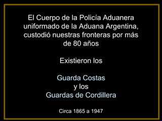
1. El Cuerpo de la Policía Aduanera
uniformado de la Aduana Argentina,
custodió nuestras fronteras por más
de 80 años
Existieron los
Guarda Costas
y los
Guardas de Cordillera
Circa 1865 a 1947
2. continuación
GENTILEZA Y COLECCIÓN: BIBLIOTECA DE ADUANA
3. Patrulla de frontera de la Policía Aduanera en la Aduana
de la Quiaca, D. Juan B. Ibáñez (destacado) – C.1918
GENTILEZA Y COLECCIÓN: DIRECTOR REGIÓN ADUANERA DE POSADAS D. HÉCTOR IBÁÑEZ (nieto)
4. A la derecha de la fotografía se
encuentra el Oficial D. Juan
Bautista Ibáñez a cargo del
Destacamento de la Policía
Aduanera en la Aduana de la
Quiaca C. 1930
Prestó servicios en frontera
entre 1914 y 1952
GENTILEZA Y COLECCIÓN: DIRECTOR REGIÓN ADUANERA DE POSADAS D. HÉCTOR IBÁÑEZ (nieto)
5. Destacamento de la Policía Aduanera en la Quiaca el Oficial
Ibáñez (destacado) – C 1930
GENTILEZA Y COLECCIÓN: DIRECTOR REGIÓN ADUANERA DE POSADAS D. HÉCTOR IBÁÑEZ (nieto)
6. Resguardo Aduana de Jujuy - Policía Aduanera en la cordillera. El Oficial
D. Juan B. Ibáñez (destacado) (1914/1953), otros Oficiales, Suboficiales,
Tropa y Funcionarios de Aduana – C.1932
GENTILEZA: ADUANA DE CONCORDIA Y DIRECTOR REGIÓN ADUANERA DE POSADAS D. HÉCTOR IBÁÑEZ (nieto)
8. Oficial Superior en Jefe,
perteneciente al Cuerpo de la
Policía Aduanera de la
Dirección General de Aduanas.
D. Edelmiro Nicolás Mallotti
Circa 1928
GENTILEZA Y COLECCIÓN:
D. PEDRO MARCHETTI
9. En esta fotografía se puede
apreciar perfectamente
como era el uniforme
completo de un Oficial de la
Policía Aduanera que
portaba pistola Ballester
Molina 11.25 mm y sable
tipo Gallo.
GENTILEZA Y
COLECCIÓN:
MARÍA LAURA TORTI
(nieta) y JOSÉ LUIS
GIROTTI
10. Una muestra sobre el accionar del Cuerpo de Policía Aduanera con el
Oficial D. Aníbal Pedro Torti y personal a su cargo – Circa 1944
12. En esta fotografía se
aprecia el uniforme
completo de los
Agentes de la Policía
Aduanera que
portaban revolver
S&W 38 largo.
C. 1944
GENTILEZA Y
COLECCIÓN:
MARÍA LAURA TORTI
(nieta) y JOSÉ LUIS
GIROTTI
13. Gentileza del ex Oficial del Cuerpo de la Policía Aduanera, señor José Lupiañez. En
los últimos años de su carrera, fue Inspector a Cargo del Servicio de Guardia de la
Policía Aduanera en la Aduana Central. Se retiró en 1990. Foto C.1947
19. DIRECCIÓN GENERAL DE ADUANAS
CARTILLA DEL GUARDA COSTAS
1938
1) El Guarda Costas es el Agente de la Policía
Aduanera uniformado y con armas, que tiene a su
cargo la vigilancia de los lugares donde está destacado,
bien sea zonas portuarias, ríos, costas y
fronteras terrestres, por donde puedan entrar o salir
mercaderías sujetas al pago de derechos y servicios
fiscales, para impedir la realización de contrabandos o
infracciones que se intenten en perjuicio de la renta que
al Fisco corresponda.
20. ESCALA JERÁRQUICA
FUNCIONARIOS SUPERIORES
DIRECTOR GENERAL DE ADUANAS
INSPECTOR DE RENTAS
ADMINISTRADOR O RECEPTOR
DIRECTOR O JEFE DE RESGUARDO
JEFE DE INSPECTORES
INSPECTOR DE LAS ADUANAS PRINCIPALES
21. JEFES
INSPECTOR JEFE DEL CUERPO DE GUARDA COSTAS.
2º JEFE DEL CUERPO DE GUARDA COSTAS.
JEFE DE MAYORÍA DEL CUERPO DE GUARDA COSTAS.
OFICIALES
AUXILIAR.
OFICIAL INSPECTOR
OFICIAL AYUDANTE
ESCRIBIENTE
MERITORIO
CLASES
SARGENTO
CABO
AGENTES
22. PROPIEDAD DE LA DIRECCIÓN GENERAL DE ADUANAS
PISTOLAS 11.25
BALLESTER MOLINA
Pistola reglamentaria original de los Oficiales del Cuerpo de la Policía
Aduanera uniformada hasta 1947/48
23. PROPIEDAD DE LA DIRECCIÓN GENERAL DE ADUANAS
PISTOLAS 11.25
BALLESTER MOLINA
24. PROPIEDAD DE LA DIRECCIÓN GENERAL DE ADUANAS
Revolver Smith & Wesson
calibre 38 largo.
Revolver reglamentario original de los Suboficiales y la tropa del Cuerpo de la
Policía Aduanera uniformada hasta 1948.
25. FUSILES MAUSER
REVOLVER 38
PROPIEDAD DE LA DIRECCIÓN GENERAL DE ADUANAS
BALLESTER RIGAUD 11.25 REVOLVER COLT 38
Armamento reglamentario del Cuerpo de la Policía Aduanera
25
uniformada hasta 1948
30. Placas utilizadas sobre el lado superior izquierdo de la chaqueta, por los
Suboficiales y los Agentes, de los Guarda Costas y los Guardas de Cordillera
del Cuerpo de la Policía Aduanera. Este modelo de placa sería el más
antiguo que se tenga conocimiento, C. Siglo XIX.
31. Como se puede observar las placas
de identificación, tenían similar
diseño que los escudos de los
Destacamentos de la Policía
Aduanera.
GENTILEZA Y COLECCIÓN: ADUANA DE COMODORO RIVADAVIA
32. Lancha del
Guarda Costas
de Policía Aduanera
”P. A. 2”
Aduana de Bahía Blanca
Circa 1930/39
33. Esta fotografía de autor anónimo muestra una de las lanchas del Guarda Costas de la Policía
Aduanera y el personal uniformado a cargo de la navegación, fue propiedad del Inspector Mayor
D. Pedro Marchetti, que permitió gentilmente digitalizarla, antes de su fallecimiento. Al dorso se
encuentra asentado en manuscrito “Aduana de Bahía Blanca” se estima que pertenecería a la
década de 1930.
34. El Jefe de la División Resguardo 1, señor Alfredo Muzio y el 2do. Jefe
señor Eduardo Di Grigoli de la Aduana de Buenos Aires, tuvieron la
magnífica idea en el año 2010 de realizar la maqueta de esta histórica
lancha.
Para ello encomendaron la tarea a un Modelista Naval, que con los
escasos antecedentes y planos que obran en el Boletín de la Dirección
General de Aduanas nº 1 de 1938 y la fotografía de la nave, el señor
Hugo Pinilla sumó averiguaciones técnicas para poder construirla. La
misma se asemeja a uno de los distintos tipos y modelos de
embarcación, que pertenecieron por más de 80 años a la Policía
Aduanera para patrullar ríos y mares de todo el país, hasta 1947/1948.