Denunciar
Compartir

Recomendados
Unit 5. al andalus&art
The document provides an overview of the history and culture of Al-Andalus. It summarizes that:
The Muslim conquest of the Iberian Peninsula began in 711 CE and within a few years they had occupied nearly the entire region, establishing the independent Emirate of Cordoba by 756 CE. This evolved into the powerful Caliphate of Cordoba from 929-1031 CE, which saw a golden age of culture and learning. However, internal conflicts later caused the fragmentation of Al-Andalus into competing taifa states by 1031 CE, weakening the region as Christian kingdoms grew in strength. The last remnants of Muslim rule in Iberia ended with the fall of Granada
Unit4.art in the middle ages
During the Middle Ages between the 10th-15th centuries, the dominant artistic styles in Europe were Romanesque and Gothic. Romanesque art spread throughout Europe in the 11th-12th centuries featuring thick walls, rounded arches and barrel vaults in architecture along with rigid religious sculptures and paintings. Gothic art emerged in 12th century France using pointed arches, rib vaults and flying buttresses allowing taller buildings filled with stained glass windows illuminating religious subjects. Gothic sculptures showed more emotion and movement while paintings included stained glass, manuscripts, altarpieces and later portraits.
Spelling bee 2 eso ss
This document appears to list various terms related to European history between approximately 500-1500 AD. Key terms include those related to medieval feudalism such as nobility, fief, and vassalage. Religious topics are also represented including clergy, cathedral, heresy, inquisition, monasticism, crusade, and schism. Military and economic aspects of the middle ages include terms like cavalry, barracks, guild, and irrigation. The list touches on interactions with other cultures through missionary work, mosques, and conversion.
Unit4 climate
This document discusses the atmosphere and factors that influence climate and weather. It covers the layers of the atmosphere, temperature variations based on altitude and latitude, different types of precipitation and what influences precipitation amounts. It also discusses atmospheric pressure and winds, how weather maps work, and how human activities like air pollution and greenhouse gas emissions can impact climate through global warming and climate change.
Glossary unit4
This document defines key architectural terms used in medieval churches during the Romanesque and Gothic periods. It explains elements like the ambulatory, apse, barrel vault, buttresses, capitals, domes, flying buttresses, gargoyles, pointed arches, portals, ribbed vaults, and the Latin cross plan. Stylistically, it distinguishes between the Romanesque style from the 11th-12th centuries and the later widespread Gothic style from the mid-12th century onwards.
Political map of spain
España está dividida en 17 comunidades autónomas y 2 ciudades autónomas. Cada comunidad autónoma contiene varias provincias y cada provincia tiene una capital. El documento lista cada comunidad autónoma y sus respectivas provincias y capitales.
Political map of europe
This document provides instructions for locating and labeling countries on a political map of Europe. Students are asked to locate all European states listed, color and mark the capitals of countries that are members of the European Union, and note that the United Kingdom is leaving the EU in 2019 after a 2016 referendum. Countries that must be located include EU members like Germany, France, and Spain, as well as non-members such as Russia, Ukraine, and Turkey.
Physical map of europe contents
This document provides a physical map of Europe, locating major mountain ranges, plains, peninsulas, and straits on the continent. It also maps the oceans, seas, islands, and rivers of Europe, identifying locations such as the Alps, Great European Plain, Gibraltar Strait, Iceland, Baltic Sea, Thames River, and Danube River.
Contents physical relief of spain
1. Spain has several mountain ranges that run along its borders and interior, including the Cantabrian Mountains along the northern coast, the Pyrenees along the northern border with France, and the Baetic mountain ranges in the south.
2. The country also has two high plateaus in its center, the Northern Plateau and Southern Plateau, as well as river basins such as the Ebro Basin and Guadalquivir Basin.
3. Off its coasts are the Canary Islands and Balearic Islands, with notable mountains like Teide on Tenerife and Sa Tramontana on Mallorca.
Glossary unit3
The document defines key terms from the High Middle Ages, including:
- Apprentice, who worked without salary to learn a trade from a master.
- Black Death, a plague that killed 25 million Europeans between 1347-1352.
- Guilds, associations of artisans in the same trade.
- Parliaments, assemblies that helped monarchs raise taxes and funds for wars.
High middleages
The document summarizes key developments during the High Middle Ages:
1) The period saw economic growth fueled by improved agriculture and increased trade. Cities also grew as centers of trade, production, and government.
2) Medieval cities had fortified walls, distinct neighborhoods, and large market squares at their centers. Guilds organized artisans and regulated their trades.
3) The 12th century saw a "Renaissance" of culture as cathedrals and universities were founded and literature/philosophy advanced. Royal power also increased as monarchies gained independence from feudal lords and established early parliaments.
4) The Late Middle Ages saw a crisis as the Black Death plague pandemic killed over
Glossary unit2(updated)
Feudal Europe was organized into a strict hierarchy with the king at the top who granted land to nobles in exchange for military service. Society was divided into estates with the privileged nobility and clergy who did not pay taxes unlike the unprivileged peasants who worked the lands. The system was based on a network of obligations between lords and vassals and ensured military protection in a decentralized agrarian society.
Feudal europe(updated)
The document discusses feudal Europe, beginning with the Carolingian Empire established by Charlemagne in the 8th century. After Charlemagne's death, the empire was divided among his grandsons. It then describes the second wave of invasions from Vikings, Magyars, and Muslims in the 9th-10th centuries, which weakened royal authority. This led to the rise of feudalism, a political and economic system where kings granted land to nobles who provided military service, and nobles granted land to knights and vassals, who also provided service. Feudal society was divided into three estates - nobility, clergy, and peasants - and was based around a rural, self-sufficient
Unit2.the earth'srelief(updated)
The document discusses the internal and external forces that shape the Earth's relief. Internally, tectonic plates move slowly over time, pushing the crust upwards to form folds or causing it to crack and form faults. Externally, agents like water, wind, temperature changes, and living things modify relief through erosion, transportation, and deposition of materials. Water plays a particularly important role in shaping landscapes through processes like river flow. Relief is constantly changing due to these combined internal and external forces.
Vocabulary unit2
This document defines 20 geographic landforms and ocean floor features. It describes cliffs as steep rock formations, beaches as areas of sand or pebbles along a shore, and peninsulas as areas of land mainly surrounded by water. It also defines isthmuses, capes, islands, gulfs, bays, continental shelves, continental slopes, abyssal plains, mid-ocean ridges, ocean trenches, and various landforms such as mountains, mountain ranges, valleys, plains, plateaus and basins.
Glossary unit2
Feudal Europe was organized into a strict hierarchy with the king at the top who granted land to nobles in exchange for military service. Society was divided into estates with the privileged nobility and clergy who did not pay taxes unlike the unprivileged peasants who worked the lands. The system was based on a network of obligations between lords and vassals and ensured military protection in a decentralized agrarian society.
UNIT2: Feudal europe
The document discusses feudal Europe, beginning with the Carolingian Empire established by Charlemagne in the 8th century. After Charlemagne's death, the empire was divided among his grandsons. It then describes the second wave of invasions from Vikings, Magyars, and Muslims in the 9th-10th centuries, which weakened royal authority. This led to the rise of feudalism, a political and economic system where kings granted land to nobles who provided military service, and nobles granted land to knights and vassals. Society was organized into three estates - nobility, clergy, and peasants, with peasants divided into serfs or free peasants. The system shaped rural life on fiefs
Unit2.theearth'srelief
The document describes the structure and composition of the Earth. It is divided into three main layers - the core, mantle, and crust. The crust is further divided into the continents and oceans. The continents make up 29% of the Earth's surface and are composed of solid rock, while the oceans cover 71% of the surface. Relief on Earth is shaped by both internal forces like tectonic plate movement and external forces such as water and wind erosion. Tectonic plates push and pull against each other, causing mountains to form, volcanoes to erupt, and earthquakes to occur at their boundaries.
Introduction to History 2ndESO
Historians investigate the past through primary and secondary sources to support their interpretations. Primary sources were created during the time under study, like coins or letters, while secondary sources are later analyses and interpretations, such as textbooks. Historians must determine if sources are authentic, distinguish facts from opinions, and consult multiple perspectives to contrast information. In addition to studying history directly, historians may examine how the past is represented in culture or study the field of historiography itself. They use techniques like timelines and maps to locate events in time and space.
El desarrollo de las ciudades Ed.Media
El documento describe los cambios sociales, económicos y políticos que ocurrieron en Europa durante el siglo XII, incluyendo el crecimiento de la agricultura, el comercio y las ciudades, así como el fortalecimiento del poder real y el surgimiento de universidades y nuevas técnicas bancarias. También menciona conflictos como la división de la cristiandad y la peste negra que asoló Europa en la segunda mitad del siglo.
Unit4 Answer Key
This document appears to be from a geography textbook or workbook. It contains various exercises, activities, and passages about climate and weather-related topics like the greenhouse effect, global warming, natural disasters, and making climographs. The pages include images, maps, and graphs for students to analyze and questions to answer.
Vocabulary Unit4
This document defines key terms related to climate and weather, including:
- Weather is the atmospheric conditions in a particular time and place, while climate is the conditions over a long period of time in a region.
- Temperature, humidity, atmospheric pressure, and precipitation are all measured and shown on maps using lines connecting areas with the same values.
- Weather maps depict features like high and low pressure systems, fronts, and air mass boundaries.
- The Earth is divided into climate zones based on average temperature, including tropical, temperate, and polar zones.
- Wind is caused by differences in atmospheric pressure between two locations. Jet streams are high-altitude wind currents.
La Europa feudal
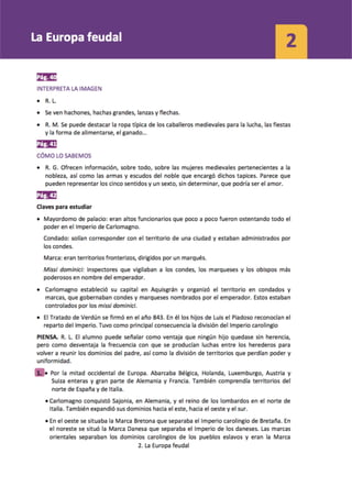
El documento describe el surgimiento y desarrollo del Imperio carolingio bajo Carlomagno, su división tras su muerte y el establecimiento del feudalismo. Carlomagno expandió el reino franco y fue coronado emperador por el Papa en 800. A su muerte, el imperio se dividió y surgieron reinos como Francia y el Sacro Imperio Romano Germánico. El feudalismo surgió ante la debilidad real con nobles otorgando protección a campesinos a cambio de trabajo en sus tierras.
Unit 3. Water
The document discusses the water cycle and the different forms and locations of water on Earth. Most of the Earth's water is located in oceans and seas, which make up 97% of the total water. The remaining 3% is continental water found in rivers, lakes, glaciers, and underground. Water is constantly moving between these different locations and states through precipitation, evaporation, runoff into rivers and oceans, and melting of ice and snow. Rivers flow from their source downstream through three stages - upper, middle and lower courses - before emptying into oceans, lakes, or other bodies of water.
Arte medieval (I) 2ºESO
El documento presenta información sobre los estilos arquitectónicos medievales visigodo, bizantino y musulmán. Describe elementos arquitectónicos como el arco de herradura visigodo e islámico, así como plantas y decoraciones típicas de edificios notables como la mezquita de Córdoba, la Alhambra y Santa Sofía. También resume la influencia de estos estilos en el arte, con ejemplos de mosaicos bizantinos, cerámica y artes islámicas.
INICIO DE LA EDAD MEDIA 2ºESO
1. La fragmentación del Imperio Romano llevó a la división del imperio en dos partes y a la formación de reinos germánicos en Occidente mientras que el Imperio Bizantino, con capital en Constantinopla, perduró otros mil años en Oriente experimentando una época de esplendor bajo Justiniano antes de una larga decadencia.
AGENDA
This document provides information and instructions for a student about various sections in their school agenda. It explains that the student should fill out personal information sheets with their parents and have them signed. It also outlines where to find teacher information, the school calendar, rules for students, consequences for different types of infractions, how to use the monthly planner and diary, the importance of taking notes in classes even without homework, forms for communication between family and school, and authorization to leave the classroom. The student is advised to consider the next day's schedule to help organize their homework.
Técnica de subrayado
Este documento proporciona consejos para subrayar textos de manera efectiva, incluyendo leer el texto primero sin subrayar para distinguir entre lo principal y secundario, usar dos colores diferentes para ideas clave y secundarias, subrayar palabras o frases en lugar de líneas completas, y asegurarse de que la mayoría de palabras subrayadas sean sustantivos.
Soluciones Examen de Selectividad. Geografía junio 2024 (Convocatoria Ordinar...
Criterios de corrección y soluciones al examen de Geografía de Selectividad (EvAU) Junio de 2024 en Castilla La Mancha.
Soluciones al examen.
Convocatoria Ordinaria.
Examen resuelto de Geografía
conocer el examen de geografía de julio 2024 en:
https://blogdegeografiadejuan.blogspot.com/2024/06/soluciones-examen-de-selectividad.html
http://blogdegeografiadejuan.blogspot.com/
Más contenido relacionado
Más de bego docencia
Contents physical relief of spain
1. Spain has several mountain ranges that run along its borders and interior, including the Cantabrian Mountains along the northern coast, the Pyrenees along the northern border with France, and the Baetic mountain ranges in the south.
2. The country also has two high plateaus in its center, the Northern Plateau and Southern Plateau, as well as river basins such as the Ebro Basin and Guadalquivir Basin.
3. Off its coasts are the Canary Islands and Balearic Islands, with notable mountains like Teide on Tenerife and Sa Tramontana on Mallorca.
Glossary unit3
The document defines key terms from the High Middle Ages, including:
- Apprentice, who worked without salary to learn a trade from a master.
- Black Death, a plague that killed 25 million Europeans between 1347-1352.
- Guilds, associations of artisans in the same trade.
- Parliaments, assemblies that helped monarchs raise taxes and funds for wars.
High middleages
The document summarizes key developments during the High Middle Ages:
1) The period saw economic growth fueled by improved agriculture and increased trade. Cities also grew as centers of trade, production, and government.
2) Medieval cities had fortified walls, distinct neighborhoods, and large market squares at their centers. Guilds organized artisans and regulated their trades.
3) The 12th century saw a "Renaissance" of culture as cathedrals and universities were founded and literature/philosophy advanced. Royal power also increased as monarchies gained independence from feudal lords and established early parliaments.
4) The Late Middle Ages saw a crisis as the Black Death plague pandemic killed over
Glossary unit2(updated)
Feudal Europe was organized into a strict hierarchy with the king at the top who granted land to nobles in exchange for military service. Society was divided into estates with the privileged nobility and clergy who did not pay taxes unlike the unprivileged peasants who worked the lands. The system was based on a network of obligations between lords and vassals and ensured military protection in a decentralized agrarian society.
Feudal europe(updated)
The document discusses feudal Europe, beginning with the Carolingian Empire established by Charlemagne in the 8th century. After Charlemagne's death, the empire was divided among his grandsons. It then describes the second wave of invasions from Vikings, Magyars, and Muslims in the 9th-10th centuries, which weakened royal authority. This led to the rise of feudalism, a political and economic system where kings granted land to nobles who provided military service, and nobles granted land to knights and vassals, who also provided service. Feudal society was divided into three estates - nobility, clergy, and peasants - and was based around a rural, self-sufficient
Unit2.the earth'srelief(updated)
The document discusses the internal and external forces that shape the Earth's relief. Internally, tectonic plates move slowly over time, pushing the crust upwards to form folds or causing it to crack and form faults. Externally, agents like water, wind, temperature changes, and living things modify relief through erosion, transportation, and deposition of materials. Water plays a particularly important role in shaping landscapes through processes like river flow. Relief is constantly changing due to these combined internal and external forces.
Vocabulary unit2
This document defines 20 geographic landforms and ocean floor features. It describes cliffs as steep rock formations, beaches as areas of sand or pebbles along a shore, and peninsulas as areas of land mainly surrounded by water. It also defines isthmuses, capes, islands, gulfs, bays, continental shelves, continental slopes, abyssal plains, mid-ocean ridges, ocean trenches, and various landforms such as mountains, mountain ranges, valleys, plains, plateaus and basins.
Glossary unit2
Feudal Europe was organized into a strict hierarchy with the king at the top who granted land to nobles in exchange for military service. Society was divided into estates with the privileged nobility and clergy who did not pay taxes unlike the unprivileged peasants who worked the lands. The system was based on a network of obligations between lords and vassals and ensured military protection in a decentralized agrarian society.
UNIT2: Feudal europe
The document discusses feudal Europe, beginning with the Carolingian Empire established by Charlemagne in the 8th century. After Charlemagne's death, the empire was divided among his grandsons. It then describes the second wave of invasions from Vikings, Magyars, and Muslims in the 9th-10th centuries, which weakened royal authority. This led to the rise of feudalism, a political and economic system where kings granted land to nobles who provided military service, and nobles granted land to knights and vassals. Society was organized into three estates - nobility, clergy, and peasants, with peasants divided into serfs or free peasants. The system shaped rural life on fiefs
Unit2.theearth'srelief
The document describes the structure and composition of the Earth. It is divided into three main layers - the core, mantle, and crust. The crust is further divided into the continents and oceans. The continents make up 29% of the Earth's surface and are composed of solid rock, while the oceans cover 71% of the surface. Relief on Earth is shaped by both internal forces like tectonic plate movement and external forces such as water and wind erosion. Tectonic plates push and pull against each other, causing mountains to form, volcanoes to erupt, and earthquakes to occur at their boundaries.
Introduction to History 2ndESO
Historians investigate the past through primary and secondary sources to support their interpretations. Primary sources were created during the time under study, like coins or letters, while secondary sources are later analyses and interpretations, such as textbooks. Historians must determine if sources are authentic, distinguish facts from opinions, and consult multiple perspectives to contrast information. In addition to studying history directly, historians may examine how the past is represented in culture or study the field of historiography itself. They use techniques like timelines and maps to locate events in time and space.
El desarrollo de las ciudades Ed.Media
El documento describe los cambios sociales, económicos y políticos que ocurrieron en Europa durante el siglo XII, incluyendo el crecimiento de la agricultura, el comercio y las ciudades, así como el fortalecimiento del poder real y el surgimiento de universidades y nuevas técnicas bancarias. También menciona conflictos como la división de la cristiandad y la peste negra que asoló Europa en la segunda mitad del siglo.
Unit4 Answer Key
This document appears to be from a geography textbook or workbook. It contains various exercises, activities, and passages about climate and weather-related topics like the greenhouse effect, global warming, natural disasters, and making climographs. The pages include images, maps, and graphs for students to analyze and questions to answer.
Vocabulary Unit4
This document defines key terms related to climate and weather, including:
- Weather is the atmospheric conditions in a particular time and place, while climate is the conditions over a long period of time in a region.
- Temperature, humidity, atmospheric pressure, and precipitation are all measured and shown on maps using lines connecting areas with the same values.
- Weather maps depict features like high and low pressure systems, fronts, and air mass boundaries.
- The Earth is divided into climate zones based on average temperature, including tropical, temperate, and polar zones.
- Wind is caused by differences in atmospheric pressure between two locations. Jet streams are high-altitude wind currents.
La Europa feudal
El documento describe el surgimiento y desarrollo del Imperio carolingio bajo Carlomagno, su división tras su muerte y el establecimiento del feudalismo. Carlomagno expandió el reino franco y fue coronado emperador por el Papa en 800. A su muerte, el imperio se dividió y surgieron reinos como Francia y el Sacro Imperio Romano Germánico. El feudalismo surgió ante la debilidad real con nobles otorgando protección a campesinos a cambio de trabajo en sus tierras.
Unit 3. Water
The document discusses the water cycle and the different forms and locations of water on Earth. Most of the Earth's water is located in oceans and seas, which make up 97% of the total water. The remaining 3% is continental water found in rivers, lakes, glaciers, and underground. Water is constantly moving between these different locations and states through precipitation, evaporation, runoff into rivers and oceans, and melting of ice and snow. Rivers flow from their source downstream through three stages - upper, middle and lower courses - before emptying into oceans, lakes, or other bodies of water.
Arte medieval (I) 2ºESO
El documento presenta información sobre los estilos arquitectónicos medievales visigodo, bizantino y musulmán. Describe elementos arquitectónicos como el arco de herradura visigodo e islámico, así como plantas y decoraciones típicas de edificios notables como la mezquita de Córdoba, la Alhambra y Santa Sofía. También resume la influencia de estos estilos en el arte, con ejemplos de mosaicos bizantinos, cerámica y artes islámicas.
INICIO DE LA EDAD MEDIA 2ºESO
1. La fragmentación del Imperio Romano llevó a la división del imperio en dos partes y a la formación de reinos germánicos en Occidente mientras que el Imperio Bizantino, con capital en Constantinopla, perduró otros mil años en Oriente experimentando una época de esplendor bajo Justiniano antes de una larga decadencia.
AGENDA
This document provides information and instructions for a student about various sections in their school agenda. It explains that the student should fill out personal information sheets with their parents and have them signed. It also outlines where to find teacher information, the school calendar, rules for students, consequences for different types of infractions, how to use the monthly planner and diary, the importance of taking notes in classes even without homework, forms for communication between family and school, and authorization to leave the classroom. The student is advised to consider the next day's schedule to help organize their homework.
Técnica de subrayado
Este documento proporciona consejos para subrayar textos de manera efectiva, incluyendo leer el texto primero sin subrayar para distinguir entre lo principal y secundario, usar dos colores diferentes para ideas clave y secundarias, subrayar palabras o frases en lugar de líneas completas, y asegurarse de que la mayoría de palabras subrayadas sean sustantivos.
Más de bego docencia (20)
Último
Soluciones Examen de Selectividad. Geografía junio 2024 (Convocatoria Ordinar...
Criterios de corrección y soluciones al examen de Geografía de Selectividad (EvAU) Junio de 2024 en Castilla La Mancha.
Soluciones al examen.
Convocatoria Ordinaria.
Examen resuelto de Geografía
conocer el examen de geografía de julio 2024 en:
https://blogdegeografiadejuan.blogspot.com/2024/06/soluciones-examen-de-selectividad.html
http://blogdegeografiadejuan.blogspot.com/
p4s.co Ecosistema de Ecosistemas - Diagrama.pdf
Ofrecemos herramientas y metodologías para que las personas con ideas de negocio desarrollen un prototipo que pueda ser probado en un entorno real.
Cada miembro puede crear su perfil de acuerdo a sus intereses, habilidades y así montar sus proyectos de ideas de negocio, para recibir mentorías .
Hablemos de ESI para estudiantes Cuadernillo
Cuadernillo Hablemos de ESI para estudiantes del nivel secundario
ACERTIJO DESCIFRANDO CÓDIGO DEL CANDADO DE LA TORRE EIFFEL EN PARÍS. Por JAVI...
El Mtro. JAVIER SOLIS NOYOLA crea y desarrolla el “DESCIFRANDO CÓDIGO DEL CANDADO DE LA TORRE EIFFEL EN PARIS”. Esta actividad de aprendizaje propone el reto de descubrir el la secuencia números para abrir un candado, el cual destaca la percepción geométrica y conceptual. La intención de esta actividad de aprendizaje lúdico es, promover los pensamientos lógico (convergente) y creativo (divergente o lateral), mediante modelos mentales de: atención, memoria, imaginación, percepción (Geométrica y conceptual), perspicacia, inferencia y viso-espacialidad. Didácticamente, ésta actividad de aprendizaje es transversal, y que integra áreas del conocimiento: matemático, Lenguaje, artístico y las neurociencias. Acertijo dedicado a los Juegos Olímpicos de París 2024.
FEEDBACK DE LA ESTRUCTURA CURRICULAR- 2024.pdf
José Luis Jiménez Rodríguez
Junio 2024.
“La pedagogía es la metodología de la educación. Constituye una problemática de medios y fines, y en esa problemática estudia las situaciones educativas, las selecciona y luego organiza y asegura su explotación situacional”. Louis Not. 1993.
Examen de Selectividad. Geografía junio 2024 (Convocatoria Ordinaria). UCLM
Examen de Selectividad de la EvAU de Geografía de junio de 2023 en Castilla La Mancha. UCLM . (Convocatoria ordinaria)
Más información en el Blog de Geografía de Juan Martín Martín
http://blogdegeografiadejuan.blogspot.com/
Este documento presenta un examen de geografía para el Acceso a la universidad (EVAU). Consta de cuatro secciones. La primera sección ofrece tres ejercicios prácticos sobre paisajes, mapas o hábitats. La segunda sección contiene preguntas teóricas sobre unidades de relieve, transporte o demografía. La tercera sección pide definir conceptos geográficos. La cuarta sección implica identificar elementos geográficos en un mapa. El examen evalúa conocimientos fundamentales de geografía.
La necesidad de bienestar y el uso de la naturaleza.pdf
La necesidad de bienestar y el uso de la naturaleza
Libro Integrado 8vo egb len-mat-ccnn-eess
El curso de Texto Integrado de 8vo grado es un programa académico interdisciplinario que combina los contenidos y habilidades de varias asignaturas clave. A través de este enfoque integrado, los estudiantes tendrán la oportunidad de desarrollar una comprensión más holística y conexa de los temas abordados.
En el área de Estudios Sociales, los estudiantes profundizarán en el estudio de la historia, geografía, organización política y social, y economía de América Latina. Analizarán los procesos de descubrimiento, colonización e independencia, las características regionales, los sistemas de gobierno, los movimientos sociales y los modelos de desarrollo económico.
En Lengua y Literatura, se enfatizará el desarrollo de habilidades comunicativas, tanto en la expresión oral como escrita. Los estudiantes trabajarán en la comprensión y producción de diversos tipos de textos, incluyendo narrativos, expositivos y argumentativos. Además, se estudiarán obras literarias representativas de la región latinoamericana.
El componente de Ciencias Naturales abordará temas relacionados con la biología, la física y la química, con un enfoque en la comprensión de los fenómenos naturales y los desafíos ambientales de América Latina. Se explorarán conceptos como la biodiversidad, los recursos naturales, la contaminación y el desarrollo sostenible.
En el área de Matemática, los estudiantes desarrollarán habilidades en áreas como la aritmética, el álgebra, la geometría y la estadística. Estos conocimientos matemáticos se aplicarán a la resolución de problemas y al análisis de datos, en el contexto de las temáticas abordadas en las otras asignaturas.
A lo largo del curso, se fomentará la integración de los contenidos, de manera que los estudiantes puedan establecer conexiones significativas entre los diferentes campos del conocimiento. Además, se promoverá el desarrollo de habilidades transversales, como el pensamiento crítico, la resolución de problemas, la investigación y la colaboración.
Mediante este enfoque de Texto Integrado, los estudiantes de 8vo grado tendrán una experiencia de aprendizaje enriquecedora y relevante, que les permitirá adquirir una visión más amplia y comprensiva de los temas estudiados.
Último (20)
Soluciones Examen de Selectividad. Geografía junio 2024 (Convocatoria Ordinar...
Soluciones Examen de Selectividad. Geografía junio 2024 (Convocatoria Ordinar...
Docentes y el uso de chatGPT en el Aula Ccesa007.pdf
Docentes y el uso de chatGPT en el Aula Ccesa007.pdf
pueblos originarios de chile presentacion twinkl.pptx
pueblos originarios de chile presentacion twinkl.pptx
Las Tecnologias Digitales en los Aprendizajesdel Siglo XXI UNESCO Ccesa007.pdf
Las Tecnologias Digitales en los Aprendizajesdel Siglo XXI UNESCO Ccesa007.pdf
CONTENIDOS Y PDA DE LA FASE 3,4 Y 5 EN NIVEL PRIMARIA
CONTENIDOS Y PDA DE LA FASE 3,4 Y 5 EN NIVEL PRIMARIA
3° SES COMU LUN10 CUENTO DIA DEL PADRE 933623393 PROF YESSENIA (1).docx
3° SES COMU LUN10 CUENTO DIA DEL PADRE 933623393 PROF YESSENIA (1).docx
ACERTIJO DESCIFRANDO CÓDIGO DEL CANDADO DE LA TORRE EIFFEL EN PARÍS. Por JAVI...
ACERTIJO DESCIFRANDO CÓDIGO DEL CANDADO DE LA TORRE EIFFEL EN PARÍS. Por JAVI...
Inteligencia Artificial para Docentes HIA Ccesa007.pdf
Inteligencia Artificial para Docentes HIA Ccesa007.pdf
Examen de Selectividad. Geografía junio 2024 (Convocatoria Ordinaria). UCLM
Examen de Selectividad. Geografía junio 2024 (Convocatoria Ordinaria). UCLM
La necesidad de bienestar y el uso de la naturaleza.pdf
La necesidad de bienestar y el uso de la naturaleza.pdf