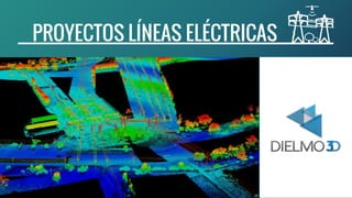
Líneas eléctricas con datos LiDAR - Estudios de riesgo, cartografía y PLS-CADD
•Descargar como PPTX, PDF•
0 recomendaciones•341 vistas

Este documento describe los servicios y procesos de una compañía para proyectos de líneas eléctricas, incluyendo procesamiento LiDAR, modelado PLS-CADD, y soluciones en la nube. Ofrece procesamiento de datos LiDAR personalizado, modelado de precisión, y más de 20 años de experiencia internacional en proyectos de líneas eléctricas.

Recomendados
Más contenido relacionado
Destacado
Similar a Líneas eléctricas con datos LiDAR - Estudios de riesgo, cartografía y PLS-CADD
Similar a Líneas eléctricas con datos LiDAR - Estudios de riesgo, cartografía y PLS-CADD (20)
Último
Último (20)
Líneas eléctricas con datos LiDAR - Estudios de riesgo, cartografía y PLS-CADD
- 2. PRINCIPALES PRODUCTOS INFORMES MODELADO PLS-CADD CLASIFICACIÓN LiDAR Y ACTUALIZACIÓN DE LA RED VEGETACIÓN PELIGROSA Y ESTUDIO DE DISTANCIAS DE SEGURIDAD AL SUELO SERVICIOS WEB
- 3. NUESTRA EXPERIENCIA SOFTWARE PROPIO FLEXIBLE PRODUCTOS Y SERVICIOS PERSONALIZADOS LA MEJOR CALIDAD A PRECIOS COMPETITIVOS CONTROL DE CALIDAD 99,9% EXPERIENCIA INTERNACIONAL + 60.000 KM Con una experiencia de más de 60.000 km en proyectos de líneas eléctricas, le garantizamos el mejor servicio y calidad para su proyecto. La habilidad de poder ajustar nuestro software interno para ofrecer soluciones de procesado personalizadas nos permite satisfacer las necesidades de nuestros clientes, siendo una alternativa atractiva y fiable frente al procesado LiDAR “clásico”
- 4. FASES PROCESADO LiDAR Delivery of raw LAS files. Auto classification of raw data Measure FL and Z errors in overlaps. Flight line adjustment in Z. Check and correct errors in XY. Select FL to refly Intensity image and objects > 3m mask. 2D vector of poles and conductors. QA of vectors with objects > 3m mask and reference vectors Check non capture regions Report non capture regions if necessary Select Study Data from Total Data Pool and Auto-classify Poles and Conductors Apply the flight line adjustment. LAS manual editing. Roads vectors. QA of vectors / Ids Compute PI and ground QA. QA of LAS classification Compute and edit patches. 2D vector of crossings. Prepare vectors to compute offending Vegetation (OV). Compute OV v1 QA of OV v1 Edit errors detected in OV v1. Recompute OV v2 Second QA of OV2. Edit errors detected in OV2. Compute the OV volume by span Prepare delivery of Offending Vegetation. Delivery of Offending Vegetation. Compute Report Premodeling QA of Report Premodeling. Edit errors detected in report pre-modeling. Insert Roads and MKP in LAS files. QA of overlaps with other Blocks. Prepare delivery of the other products. Delivery of the other products. 2- CLASIFICACIÓN LiDAR, VEGETACIÓN PELIGROSA Y CONTROL DE CALIDAD 1- PREPARACIÓN Y CORRECCIÓN DE DATOS ANTES DEL PROCESADO 3- PRODUCTOS FINALES, INFORMES, PRE-MODELLING Y CONTROL DE CALIDAD 6 Días laborables 7 Días laborables 8 Días laborables
- 5. RECEPCIÓN Y PREPARACIÓN FASES PROCESADO LiDAR 1- PREPARACIÓN Y CORRECCIÓN DE DATOS ANTES DEL PROCESADO ANÁLISIS Y CORRECCIÓN DE SOLAPES Y LÍNEAS DE VUELO COMPROBAR AREAS NO VOLADAS DISEÑO DE VECTORES Y CONTROL DE CALIDAD DE TORRES Y CABLES
- 6. FASES PROCESADO LiDAR EDICIÓN, CONTROL DE CALIDAD Y CORRECCIÓN DE “LAS” 2- CLASIFICACIÓN LiDAR, VEGETACIÓN PELIGROSA Y CONTROL DE CALIDAD CRUCES, CARRETERAS Y OTROS ELEMENTOS CONTROL DE CALIDAD DE LA RED DE VECTORES (OV) CÁLCULO DE VEGETACIÓN PELIGROSA Y CONTROL CALIDAD
- 7. INFORMES DISTANCIAS DE SEGURIDAD AL SUELO Y ENTRE CABLES INSERTAR ELEMENTOS Y COMPROBAR SOLAPES ENTREGA FINAL FASES PROCESADO LiDAR 3- PRODUCTOS FINALES, INFORMES, PRE-MODELLING Y CONTROL DE CALIDAD
- 8. LA MEJOR SOLUCIÓN PARA CADA PROYECTO MODELADO PLS-CADD SOLUCIONES ONLINE & CLOUD OTROS SERVICIOS LiDAR
- 9. PUNTOS DESACTIVAR CLASIFICACIÓN VEGETACIÓN INSERTAR APOYOS CREACIÓN SECCIONES LÍNEA A 50º LÍNEA A 75º REINSERTAR VEGETACIÓN MODELADO PLS-CADD MODELADO DE PRECISIÓN Y ANÁLISIS PARA SU PROYECTO
- 10. SOLUCIONES ONLINE /CLOUD PROYECTOS ONLINE, SERVIDORES Y GEO-LINKS PARA LÍNEAS ELÉCTRICAS SERVIDORES LiDAR PORTALES GIS WEB PROYECTOS GIS Y HERRAMIENTAS ONLINE GEO-LINKS
- 11. SOLUCIONES ONLINE /CLOUD EJEMPLOS DISPONIBLES VER VIDEO ONLINE DESCARGAR PDF ONLINE AQUÍ