Building spatial database for cuttack municipal corporation a geospatial tech...eSAT Journals
Abstract
Decentralized governance necessitates participatory approach which is crucial for realizing sustainable development. Accordingly,
the concerned government as well as non-government agencies assume responsibility to plan, execute, manage and monitor social
welfare schemes in a coordinated manner. This in turn, relies on integrated information in the form of database which plays a vital
role in the process of decision making. Despite significant improvements made in the field of database creation and management,
problems of availability and organization of accurate data in the country continue to persist. In this context, the present study is taken
up for building a reliable and accurate geo-database for Cuttack Municipal Corporation, Odisha. The database thus created will
enable information flow for planning and monitoring of various government schemes. The study involves acquisition and integration
of spatial and non-spatial data derived from multiple sources. More often than not, data from these sources suffer from various types
of errors embedded in it. Lack of availability of cutting edge technologies within government enterprises as well as absence of
appropriate manpower with specialized expertise are the underlying reasons of errors in existing databases of Cuttack Municipal
Corporation. The present study proposes a methodological framework towards removal of these errors in spatial information. The
study is based on geospatial technologies of Remote Sensing, Geographic Information System and Global Positioning System in
generating a desired accurate and common geo-database for planning and implementation of social welfare schemes. While Global
Positioning System and Remote Sensing imageries can help enhance the positional accuracies of spatial entities, data management,
analysis and visualization capabilities of Geographic Information System can help build the standard geo-database which can be
shared by policy makers for better implementation of the schemes.
Key words: Geospatial, Database, Remote Sensing, GIS, GPS
Accelerating Innovation with Software Supply Chain ManagementSonatype
We are going to compare building cars with building software – what we are going to realize is the car industry is leaps ahead of the software industry in managing their supply chain – the question is what can we learn from them? We will explore the question, does closely managing our supply chain have benefit in the software industry?
Instrucciones del procedimiento para la oferta y la gestión conjunta del proceso de admisión a los centros públicos de primer ciclo de educación infantil de Pamplona para el curso 2024-2025.
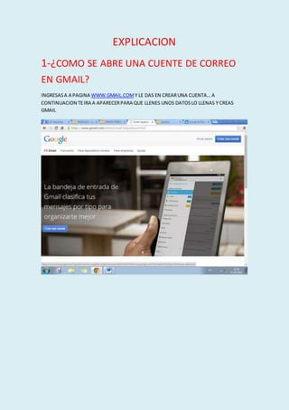
1. EXPLICACION
1-¿COMO SE ABRE UNA CUENTE DE CORREO
EN GMAIL?
INGRESASA A PAGINA WWW.GMAIL.COM Y LE DAS EN CREARUNA CUENTA… A
CONTINUACION TEIRA A APARECERPARA QUE LLENES UNOS DATOSLO LLENAS Y CREAS
GMAIL
2. PARA RECIBIRUN CORREOLE DAS UN CLIKEN EL ARCHIVOQUE QUIERES ABRIRY TE VA A
ABRIREL ARCHIVOQUE TE MANDARON…
3. PARA ENVIARUN CORREO LE DASEN EL LETRERO QUE APARECECON ROLO QUE DICE:
“REDACTAR” LE DAS CLIC Y TE VA A APARECEREL LETRERO BLANCO,EN LA PARTEQUE DICE
PARA PONESEL CORREO A LA PERSONA QUE LO VASA ENVIARY EL ASUNTOES EL QUE LA
PERSONA VA A LEER CUANDOLO VEA DE PRIMERAS
4. PARA ADJUNTARARCHIVOSLE DAS DONDE SE MUESTRA EN LA IMAGEN LE DASCLIC TE LLEVA
A ARCHIVOSYBUSCAS LO QUE VASA INSERTAR