Rápido análisis de evolución glaciar y formación de lagunas en Artesonraju
•
0 recomendaciones•844 vistas


Recomendados
Más contenido relacionado
La actualidad más candente
La actualidad más candente (17)
Destacado
Destacado (9)
Similar a Rápido análisis de evolución glaciar y formación de lagunas en Artesonraju
Similar a Rápido análisis de evolución glaciar y formación de lagunas en Artesonraju (20)
Más de InfoAndina CONDESAN
Más de InfoAndina CONDESAN (20)
Rápido análisis de evolución glaciar y formación de lagunas en Artesonraju
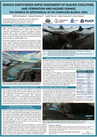
- 1. Wilfried Haeberli1, Fabian Drenkhan1,3, Judith Torres2, Alejo Cochachin2, César Salazar2 1Geography Department, University of Zurich, Switzerland 2Glaciology and Water Resources Unit, Huaraz, Peru 3Pontifical Catholic University of Peru, Lima, Peru GOOGLE-EARTH-BASED RAPID ASSESSMENT OF GLACIER EVOLUTION, LAKE FORMATION AND HAZARD CHANGE THE EXAMPLE OF ARTESONRAJU IN THE CORDILLERA BLANCA, PERU Digital high-resolution terrain information contained in Google Earth can be combined with a simple, fast, robust and transparent parameterization scheme for analyses of glacier inventory data to derive important quantitative information about the characteristics and evolution of mountain glaciers under conditions of climate change. This is demonstrated for the Artesonraju glacier, Cordillera Blanca, Peru. La información digital de terreno de alta resolución contenida en Google Earth, se puede combinar con un esquema de parametrización simple, rápido, estable y transparente para análisis de datos de inventarios glaciares para derivar relevante información cuantitativa sobre las características y la evolución de glaciares de montaña bajo condiciones del cambio climático. Ello se demuestra para el glaciar Artesonraju, Cordillera Blanca, Perú. Introduction – Introducción We determined the maximum and minimum altitude of Artesonraju at Hmax= 5420 m a.s.l., Hmin= 4720 m a.s.l. with a vertical extent ΔH= 700 m and a length L0= 3.2 km. With an average slope α= 12° and an assumed average basal shear stress τf= 150 kPa, its mean thickness along the central flowline can be estimated at nearly 100 m with a maximum thickness of around 200 m at the upper and wider part of the flat tongue. Mid-range elevation Hm as a good approximation for the Equilibrium Line Altitude (ELA) is near 5060 m a.s.l. Determinamos la altitud máxima y mínima de Artesonraju Hmax= 5420 msnm, Hmin= 4720 msnm con la extensión vertical ΔH= 700 m y la longitud L0= 3.2 km. Con pendiente promedio α= 12° y un esfuerzo de cizalla basal promedio asumido τf= 150 kPa, su espesor promedio a lo largo de la línea central del flujo se puede estimar a unos 100 m con un espesor máximo de unos 200 m en la parte superior ancha de la lengua plana. La elevación del rango medio con buena aproximación para la Línea de Equilibrio (ELA) está cerca a los 5060 msnm. With the glacier margin rising from about 4300 m a.s.l., the ELA (ΔHm ) shifted by some 200 m since the maximum extent of the Little Ice Age (LIA). This corresponds to a warming of 1 to 1.5°C if only temperature change is considered. With additional atmospheric warming by 1°C, the lower glacier end would have to rise to about 5000 m a.s.l. at the upper end of the flat glacier tongue leaving a reduced vertical extension of approximately 400 m. The mass balance at today’s terminus bt is nearly 6 m y-1 and the dynamic response time tr of the glacier about 30 to 40 years. Con el levantamiento del borde glaciar desde los 4300 msnm, la ELA (ΔHm ) se elevó unos 200 m desde la extensión máxima de la Pequeña Edad de Hielo (PEH). Ello corresponde a un calentamiento de 1 a 1,5°C solamente considerando el cambio de temperatura. Con un adicional calentamiento atmosférico de 1°C, el término inferior del glaciar tendría que elevarse a los Por lo tanto, dicha lengua plana representa probablemente un resto del siglo XX como se comprueba en los años recientes por los balances de masa observados negativos; su desaparición previsible va a habilitar la formación de una laguna de tamaño mediano (unos pocos millones m³ de volumen) en un lecho glaciar mayormente rocoso. Avalanchas de hielo con una salida tres veces la altura de hielo, pueden alcanzar la parte superior de esta laguna. Consiguientes inundaciones pueden ser retenidas en la Laguna Parón si se mantiene un bordo libre adecuado. The flat tongue is therefore likely to be a left-over from the late 20th century as confirmed by observed negative mass balances in recent years; its foreseeable vanishing will enable the formation of a medium-size lake (a few million m3 volume) in a predominant rocky glacier bed. Ice avalanches with a runout distances 3 times the drop height can reach the upper parts of this lake. Corresponding floods can be retained in the Lake Parón if an adequate freeboard is maintained. Figure 1: Overview of Artesonraju glacier (background) with Lake Parón (foreground). Dashed lines determine sectors of Figure 2 (red) and Figure 3 (orange). Figura 1: Vista conjunta del glaciar Artesonraju (fondo) con Laguna Parón (parte inferior). Líneas discontínuas determinan recortes de Figura 2 (rojo) y Figura 3 (naranja). Figure 2: Principal parameters at Artesonraju glacier (extension of 02.08.2012). Figura 2: Parámetros principales sobre glaciar Artesonraju (extensión del 02.08.2012). Figure 3: Spatial difference between recent and past LIA minimum altitude (Hmin and ΔHmin). Figura 3: Diferencia espacial entre altitud mínima reciente y PEH pasada (Hmin yΔHmin). Glacier parameters Parámetros del glaciar Artesonraju Hmax 5420 m a.s.l. Hmin 4720 m a.s.l. ΔH = Hmax - Hmin 700 m L0 3200 m α = tan-1 (ΔH / L0) 12° τf (ΔH> 500 m) 150 kPa Hm = (Hmax + Hmin) / 2 5060 m a.s.l. (~ELA) zc = w / (4 ±1) ~ 100 m zmax = 2 × zc ~ 200 m ΔHm = Δhmin / 2 -210 m (~ ELA LIA: 4850 m a.s.l.) ΔHmin = 2 × ΔHm -420 m (4300 m a.s.l.) bt = (Hm – Hmin) × db/dh 5.9 (±0.8) m tr = zmax / bt 36 (±8.5) a Identifying principal parameters – Identificando parámetros principales Climate and glacier evolution since the LIA – Evolución del clima y glaciar desde la PEH Lake formation and hazard change Formación de lagunas y cambio de amenaza References – Referencias: HAEBERLI, W. & M. HOELZLE (1995): Application of inventory data for estimating characteristics of and regional climate- change effects on mountain glaciers: a pilot study with the European Alps. – Annals of glaciology, 21, 206-212. SCHWITTER, M. P. & C.F. RAYMOND (1993): Changes in the longitudinal profiles of glaciers during advance and retreat. – Journal of Glaciology, 39 (133), 582-590. 5000 msnm hasta la parte superior final de la lengua glaciar plana dejando una extensión vertical de unos 400 m. El balance de masa del término actual bt es cercano a 6 m y-1 y el tiempo de respuesta dinámica del glaciar tr alrededor de 30 a 40 años. ΔHmin = 4300 m a.s.l. Hmin = 4720 m a.s.l. Hmin = 4720 m a.s.l. L0 = 3200 m Hm = 5060 m a.s.l. (~ ELA) Hmax= 5420 m a.s.l. ΔHm = 4850 m a.s.l. (~ ELA LIA) HOELZLE, M., HAEBERLI, W., DISCHL, M. & W. PESCHKE (2003): Secular glacier mass balances derived from cumulative glacier length changes. – Global and Planetary Change, 36, 295-306. Contact: wilfried.haeberli@geo.uzh.ch Proyecto ‘Glaciares‘ ANAANAANAANA