SIG al estudio de erosión
•Descargar como PPT, PDF•
0 recomendaciones•231 vistas

Aplicación de los SIG a estudios de erosión potencial

Recomendados
Recomendados
Más contenido relacionado
La actualidad más candente
La actualidad más candente (20)
Similar a SIG al estudio de erosión
Similar a SIG al estudio de erosión (20)
Último
Último (20)
SIG al estudio de erosión
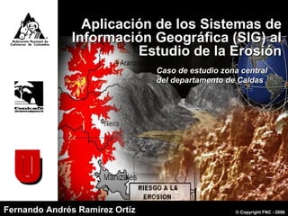
- 1. Aplicación de los Sistemas deAplicación de los Sistemas de Información Geográfica (SIG) alInformación Geográfica (SIG) al Estudio de la ErosiónEstudio de la Erosión UUT Fernando Andrés Ramírez OrtízFernando Andrés Ramírez Ortíz Caso de estudio zona centralCaso de estudio zona central del departamento de Caldasdel departamento de Caldas © Copyright FNC - 2006
- 2. © Copyright FNC – Cenicafé Septiembre de 2006 Historia y definición de SIGHistoria y definición de SIG Funciones de los SIGFunciones de los SIG ContenidoContenido Concepto de erosiónConcepto de erosión Clases de erosiónClases de erosión Principales causas de la erosiónPrincipales causas de la erosión Estudios de erosión utilizando SIGEstudios de erosión utilizando SIG Erosión en la zona cafetera central delErosión en la zona cafetera central del departamento de Caldasdepartamento de Caldas
- 3. Erosión © Copyright FNC – Cenicafé Septiembre de 2006
- 4. Proceso de separación y transporte de materiales del suelo por agentes erosivos (Ellison, 1947). Proviene del verbo latino erodere que significa roer Desgaste natural de la superficie de la tierra sin intervención del hombre Clases de erosión Erosión geológica o natural Erosión acelerada o antrópica Propiciada por el hombre al romper el equilibrio entre los suelos, la vegetación y el agua o el viento © Copyright FNC – Cenicafé Septiembre de 2006 ErosiónErosión
- 5. Formas de erosión 1. Erosión Eólica (Federacafé, 1975)© Copyright FNC – Cenicafé Septiembre de 2006
- 6. (Federacafé, 1975) 2. Erosión Hídrica Separación y dispersión de partículas del suelo Movimiento de partículas del suelo Sedimentación de partículas de suelo Impacto de las gotas de lluvia Transporte por escorrentía Formas de erosión © Copyright FNC – Cenicafé Septiembre de 2006
- 7. Geológica o natural Desgaste natural corteza terrestre Acelerada o Antrópica INTERVECIÓN DELHOMBRE Quemas y talas Surcos sentido pendiente Cultivos mal localizados Desyerbas Sobrepastoreo Carreteras mal localizadas y mal manejadas ErosiónErosión Erosión laminar Surcos Cárcavas Terracetas Solifluxión Derrumbes ACCIÓN DEL AGUA © Copyright FNC – Cenicafé Septiembre de 2006 (Federacafé, 1975) FactoresFactores
- 8. Debido: Alta presión demográfica sobre la tierra Manejo inadecuado del suelo La escasa o falta total de prácticas preventivas de conservación de suelos Condiciones propias del medio (lluvias intensas, suelos susceptibles, topografía escarpada) La erosión avanza rápidamente y amenaza: “Productividad agrícola y calidad de los suelos” (FAO, 1983, CIAT, 1995)© Copyright FNC – Cenicafé Septiembre de 2006
- 9. Detrimento total o parcial de la capa fértil del suelo. Daños por Erosión Disminución de ingresos para el agricultor por la mayor aplicación de fertilizantes y por la baja productividad en sus cosechas. La Siria, Manizales (Federacafe, 1975; FAO, 1983; CIAT, 1995)© Copyright FNC – Cenicafé Septiembre de 2006 Pérdida de la fertilidad del suelo. Formación de surcos y cárcavas.
- 10. Pérdida anual de suelo: 75 mil millones de toneladas Puntos claves de la erosión a escala mundial 1 EEUU 2 México 3 Sur América 4 N. Africa 5 Sahel 6 Bostwana - Namibia 7 Oriente Medio 8 Asia Central 9 Mongolia 10 Yangse 11 Base de los Himalayas 12 Beluchitán 13 Rajasthan 14 Australia (Myers et al., 1987; Lal, 1998; Zinck, A., 2005)© Copyright FNC – Cenicafé Septiembre de 2006 US$ 400 mil millonesUS$ 400 mil millones US$ 70 por personaUS$ 70 por persona
- 11. 11 millones de km11 millones de km22 erosión hídricaerosión hídrica 5,5 millones de km5,5 millones de km22 erosión eólicaerosión eólica 2,4 millones de km2,4 millones de km22 degradación químicadegradación química 0,8 millones de km0,8 millones de km22 degradación físicadegradación física 130 millones de km130 millones de km22 (Movillon et al.,2001 Oldeman, 2005) Equivalente alEquivalente al 15%15% superficie globalsuperficie global y aly al 66%66% tierras arablestierras arables © Copyright FNC – Cenicafé Septiembre de 2006
- 12. Zonas vulnerables a la erosiónZonas vulnerables a la erosión hídricahídrica (USDA, 2005)© Copyright FNC – Cenicafé Septiembre de 2006
- 13. (Inderena, 1977) Erosión en Colombia 1977 © Copyright FNC – Cenicafé Septiembre de 2006
- 14. Erosión en Colombia IGAC, 1988 IDEAM, 2000 © Copyright FNC – Cenicafé Septiembre de 2006
- 15. Desarrollo de técnicas de predicción de erosión Para predecir los niveles de erosión causada por el agua, se han desarrollado numerosos modelos. Estos varían en sus requerimientos de información, insumos y en su facultad para predecir otros procesos. (FAO, 2005) La erosión de los suelos es un fenómeno físico, multicondicionado. Erosión = f (Activos, Pasivos, Atemperantes) (Suárez de Castro,1962) © Copyright FNC – Cenicafé Septiembre de 2006
- 16. MODELO APLICACIÓN ESCALA DE TIEMPO ESCALA ESPACIAL a. Nivel medio-bajo de necesidades de datos Cargas por superficie unitaria (Predicción estadística). Pérdida de sedimentos pérdida de nutrientes. Promedios a largo plazo. Decenas a centenares de Km 2 . Nota: los modelos estadísticos utilizan datos agregados para situaciones comparables. La capacidad de predicción es baja, pero puede ser útil como medio de detección o en el caso de que no se dispone de datos en los medios de cultivo o la escala espacial es tan grande que resulta antieconómico obtenerlos. USLE (Ecuación Universal de Pérdida de Suelo). Pérdida media de suelo en relación con cultivos específicos. Anual. Parcela/finca. RUSLE/MUSLE (USLE Revisada/Modificada). Pérdida media de suelo en relación con cultivos específicos. Anual. Parcela/finca. Nota: los modelos empíricos semejantes al USLE se han aplicado en análisis de grandes superficies, utilizando, por ejemplo, datos obtenidos con teledetección, para elaborar estimaciones regionales de las pérdidas de suelos. Estos modelos se incorporan muchas veces en los modelos hidrológicos más detallados que se indican a continuación. Modelos para estimar las pérdidas de suelo por erosión hídrica © Copyright FNC – Cenicafé Septiembre de 2006 Beasley y Huggins (1981); FAO (1997); Vahos et al., (2003)
- 17. b. Modelos que requieren gran disponibilidad de datos (orientados hacia el proceso) AGNPS (Contaminación de fuentes agrícolas no localizadas). Hidrología, erosión, N, P y plaguicidas. Suceso aislado, diariamente, continuada. Cuadrícula, finca. ANSWER (Simulación de respuestas ambientales en cuencas hidrográficas de fuentes zonales no localizadas). Hidrología, erosión, N, P y plaguicidas. Una tormenta. Cuadrícula. CREAMS (Erosión química y escorrentía de los sistemas de ordenación agrícola). Hidrología, erosión, N, P y plaguicidas. Diaria, continuada. Finca. EPIC (Calculador del efecto erosión / productividad). Hidrología, erosión ciclo de nutrientes, ordenación de cosechas, suelos, economía. Suceso aislado diaria, continuada. Finca. SWAN (Modelo de cuencas hidrográficas pequeñas) Procesos hidrológicos, sedimentos, nutrientes y plaguicidas. Diaria, continuada. Cuenca hidrográfica. SWAT (Instrumento de evaluación de suelos y aguas). Procesos hidrológicos, sedimentos, nutrientes y plaguicidas Suceso aislado diaria, continuada. Simulación simultanea para centenares de subcuencas. SWRRB (Simulador para recursos hídricos en cuencas rurales). Balance hídrico, procesos hidrológico y sedimentación Suceso aislado diaria, continuada. Cuenca hidrográfica. WEPP (Proyecto de predicción de la erosión hídrica) Procesos hidrológicos, procesos de sedimentación Tormenta, diaria, continuada Ladera, cuenca hidrográfica, cuadricula Beasley y Huggins (1981); FAO (1997); Vahos et al., (2003) © Copyright FNC – Cenicafé Septiembre de 2006
- 18. SIG © Copyright FNC – Cenicafé Septiembre de 2006
- 19. El Dr John Snow (1813-1858). demostró que el cólera era causado por el consumo de agua contaminada con heces fecales en 1854. © Copyright FNC – Cenicafé Septiembre de 2006 (Wikimedia, 2006) HistoriaHistoria Los SIG son el paso adelante desde la invención del mapa
- 20. Desarrollo de los SIGDesarrollo de los SIG En el añoEn el año 19621962 en Canadá se diseñoen Canadá se diseño el primer SIGel primer SIG En la década de losEn la década de los 80’s80’s se empezó ase empezó a comercializarcomercializar Durante los añosDurante los años 60’s60’s yy 70’s70’s se empezó a aplicar lase empezó a aplicar la tecnología del computador digitaltecnología del computador digital © Copyright FNC – Cenicafé Septiembre de 2006 Con el transcurso delCon el transcurso del tiempotiempo se ha logrado un trabajose ha logrado un trabajo multidisciplinariomultidisciplinario HistoriaHistoria En 1988 se crea en E.U. elEn 1988 se crea en E.U. el Centro de Investigación yCentro de Investigación y Análisis Geográfico (NCGIA)Análisis Geográfico (NCGIA) (Bosque, 1992; Parra et al., 1997; CIAF, 2006)
- 21. “El SIG es un complejo sistema de hardware y software que tiene como objeto la comprensión y análisis de datos espaciales georeferenciados cuyo fin último es ayudar a las diversas actividades humanas donde los datos espaciales tienen un papel determinante” (Ortíz, 2005)© Copyright FNC – Cenicafé Septiembre de 2006 DEFINICIÓNDEFINICIÓN
- 22. Componentes de un SIGComponentes de un SIG HardwareHardware SoftwareSoftware InformaciónInformación PersonalPersonal (Aranoff, 1991)© Copyright FNC – Cenicafé Septiembre de 2006
- 23. RASTER VECTOR Mundo Real Representación espacialRepresentación espacial (Pérez, 1995; Parra et al., 1997)© Copyright FNC – Cenicafé Septiembre de 2006
- 24. © Copyright FNC – Cenicafé Septiembre de 2006c LocalizaciónLocalización Qué hay en…?Qué hay en…? (IGAC, 2005; Humbolt, 2005) Preguntas a las que responde un SIGPreguntas a las que responde un SIG
- 25. Preguntas a las que responde un SIGPreguntas a las que responde un SIG CondiciónCondición Dónde sucede qué…?Dónde sucede qué…? (ESRI, 2005; Humbolt, 2005)© Copyright FNC – Cenicafé Septiembre de 2006c
- 26. TendenciasTendencias Qué ha cambiado…?Qué ha cambiado…? (IGAC, 2005; Humbolt, 2005)© Copyright FNC – Cenicafé Septiembre de 2006c Preguntas a las que responde un SIGPreguntas a las que responde un SIG
- 27. RutasRutas Cuál es el camino óptimo…?Cuál es el camino óptimo…? (ESRI, 2005; Humbolt, 2005)© Copyright FNC – Cenicafé Septiembre de 2006c Preguntas a las que responde un SIGPreguntas a las que responde un SIG
- 28. PatronesPatrones Qué patrones existen…?Qué patrones existen…? (CIAF, 2005; Humbolt, 2005)© Copyright FNC – Cenicafé Septiembre de 2006 Preguntas a las que responde un SIGPreguntas a las que responde un SIG
- 29. ModelosModelos Qué ocurriría si…?Qué ocurriría si…? (ITC, 2005; Humbolt, 2005)© Copyright FNC – Cenicafé Septiembre de 2006 Preguntas a las que responde un SIGPreguntas a las que responde un SIG
- 30. Ciencia y tecnología relacionada con los SIGCiencia y tecnología relacionada con los SIG Percepción remotaPercepción remota CartografíaCartografía FotogrametríaFotogrametría Sistemas de gestión de datosSistemas de gestión de datos Sistema deSistema de posicionamiento globalposicionamiento global Sistema de informaciónSistema de información geográficageográfica (Delgado, 2003; Humbolt, 2005; CIAF,© Copyright FNC – Cenicafé Septiembre de 2006
- 31. © Copyright FNC – Cenicafé Septiembre de 2006 En que se utilizan los SIGEn que se utilizan los SIG (Parra et al., 1997; Pérez, 1999) Medio AmbienteMedio Ambiente AgriculturaAgricultura Gobierno y aplicaciones municipalesGobierno y aplicaciones municipales Servicios públicosServicios públicos GeologíaGeología HidrologíaHidrología Negocios y mercadeoNegocios y mercadeo
- 32. © Copyright FNC – Cenicafé Septiembre de 2006 Beneficios de un SIGBeneficios de un SIG Realizar un gran número de manipulacionesRealizar un gran número de manipulaciones Consultar rápidamente bases de datosConsultar rápidamente bases de datos Realizar pruebas analíticas complejasRealizar pruebas analíticas complejas Minimiza costos e incrementa la productividadMinimiza costos e incrementa la productividad Ayuda a la toma de decisionesAyuda a la toma de decisiones Compara eficazmente los datos espacialesCompara eficazmente los datos espaciales Efectúa análisis de forma rápidaEfectúa análisis de forma rápida Actualizaciones a través del tiempoActualizaciones a través del tiempo (Pérez, 1999; Humbolt, 2005)
- 33. Aplicaciones al estudio de la erosión © Copyright FNC – Cenicafé Septiembre de 2006
- 34. Estudios de erosión en los cuales se utilizó SIG Páez (1994), halló el riesgo a la erosión fundamentado en el análisis de dos aspectos la vulnerabilidad y el riesgo de erosión actual, usando la USLE, estimó los requerimientos de prácticas de conservación. © Copyright FNC – Cenicafé Septiembre de 2006 López et al. (1998), utilizando la (RUSLE), determinaron la influencia del uso del suelo sobre la erosión en la cuenca del Río Guadiana en Puerto Rico. Lo cual permitió hacer diferentes simulaciones de uso del suelo que indican que reforestar el 5% de las áreas más afectadas, la erosión se disminuiría en un 20% y si se reforesta la cuenca por completo la erosión se disminuiría en 37%.
- 35. © Copyright FNC – Cenicafé Septiembre de 2006 Mendivelso et al. (2000) realizaron en Colombia un estudio utilizando imágenes de satélite sobre las distintas regiones del país, donde se encontró que los procesos erosivos se concentran con mayor intensidad en la región Andina. Montes (2000), evaluó el riesgo de erosión en la Cuenca Santa Catarina mediante el análisis multiplicativo de 4 factores de la USLE (RKLS), permitió la localización de áreas potencialmente mas afectadas. Pérez (2001), calculó las pérdidas de suelo por erosión con la utilización de los factores de la USLE, para toda Colombia, observó que el 81,08% del territorio no presenta problemas graves de erosión.
- 36. (Mendivielso, et al., 2000) 50%50% de los suelosde los suelos presentan erosiónpresentan erosión 14%14% muy alta,muy alta, 10%10% alta yalta y 9%9% moderada.moderada. © Copyright FNC – Cenicafé Septiembre de 2006
- 37. Muy Alta Alta Moderada Baja Nula o Ligera Otras (Pérez S., 2001)© Copyright FNC – Cenicafé Septiembre de 2006 81%81% de los suelosde los suelos no presentanno presentan algún grado dealgún grado de erosión hídrica.erosión hídrica.
- 38. EROSIÓN Se expresa en t/ha © Copyright FNC – Cenicafé Septiembre de 2006 (IIRS-ITC)
- 39. Estudio de riesgo a la erosión en la zona central del departamento de Caldas © Copyright FNC – Cenicafé Septiembre de 2006
- 40. LIDERLIDER EDGAR HINCAPIÉ GÓMEZ Ing. Agrónomo, Investigador Científico I disciplina de Suelos COLABORADORESCOLABORADORES COMITES MUNICIPALES PERSONAL DISCIPLINA DE SISTEMAS DEPARTAMENTO DE SERVICIOS ADMINISTRATIVOS PERSONAL DISCIPLINA DE AGROCLIMATOLOGÍA ASESORESASESORES ESTHER CECILIA MONTOYA SIAVOSH SADEGHIAN KH. URIEL PÉREZ GÓMEZ Ing. Forestal. Msc. Profesor titular, Universidad del Tolima. Estadístico, MSc. Investigador Científico III, Biometría Ing. Agrónomo. MSc. Líder de la disciplina de Suelos ÁLVARO JARAMILLO ROBLEDO Ing. Agrónomo. MSc. Investigador Científico III, Agroclimatología © Copyright FNC – Cenicafé Agosto de 2005
- 41. Construir el mapa de riesgo por erosión potencial de la zona Cafetera Central del departamento de Caldas para ser utilizado como herramienta de planificación en la conservación de suelos © Copyright FNC – Cenicafé Septiembre de 2006 ObjetivoObjetivo
- 42. Identificar de zonas vulnerables a la erosión potencial a través de la evaluación de sus factores Complementar los planes y esquemas de ordenamiento territorial Aportar lineamientos a los organismos encargados de la gestión del riesgo (Decreto 919 de 1989) Contribución a la sostenibilidad de la caficultura AlcancesAlcances © Copyright FNC – Cenicafé Septiembre de 2006
- 43. Área con potencial cafetero de la zona central del departamento de Caldas 4° 55’ a 5° 42’ de Latitud Norte 75° 55’ a 75°20’ de Longitud Oeste © Copyright FNC – Cenicafé Septiembre de 2006 LocalizaciónLocalización Ecotopos 204A, 205A, 206A, 207A.
- 44. A = pérdida de suelo (t.ha) R = factor de erosividad por precipitación pluvial (MJ.mm.ha) K = factor de erodabilidad del suelo (t.ha.MJ-1 .mm-1 .ha-1 ) L = factor de longitud de pediente S = factor de gradiente de pendiente C = factor de cobertura P = factor de prácticas de conservación (Wischmeier & Smith, 1965) A = R.K.L.S.C.P Para cumplir con el objetivo se empleó la ecuación universal de pérdidas de suelo (USLE). © Copyright FNC – Cenicafé Septiembre de 2006 MetodologíaMetodología
- 45. Se utilizó los registros diarios de 34 estaciones climáticas o pluviométricas para un periodo mínimo de 10 años. Se estimó el Indice de Fournier Modificado. Factor de erosividad de la lluvia donde, Indice de Fournier Modificado Precipitación mensual (mm) Precipitación anual (mm) =IFM =p =P (Arnoldus, 1980) 12 1 2 ∑= P p IFM A = R.K.LS El IFM se correlacionó con el EI30, para hallar el factor R © Copyright FNC – Cenicafé Septiembre de 2006 MetodologíaMetodología
- 46. EstacionesEstaciones climatológicasclimatológicas (Cenicafe, 2005) COORDENANDAS ESTACIÓN lat. (n) long. (w)MUNICIPIO NOMBRE TIPO gra min. gra min. ALTITUD m Manizales La Juliana Pvm 05 8 75 29 1785 Manizales Santa Teresa Pvm 05 7 75 32 1698 Manizales Santa Teresita Pvm 05 4 75 37 1172 Filadelfia El Mirador Pvm 05 14 75 34 1650 Manizales Las Colinas Pvm 05 6 75 34 1450 Palestina Santa Ana Pvm 05 1 75 41 1278 Chinchiná La Francia Pvm 04 59 75 41 1267 Palestina La Palma Pvm 05 1 75 41 1165 Chinchiná La Sierra Pvm 04 59 75 38 1440 Palestina La Argentina Pvm 05 2 75 41 1354 Chinchiná Naranjal Ppal 04 58 75 39 1381 Balboa* La Tribuna Pvm 04 57 75 58 1580 Belén de Umbría* La Elvira Hpg 05 11 75 52 1540 Ospirna* Guatica Ppal 05 20 75 49 1661 Manizales La Selva Pvm 05 5 75 36 1312 Chinchiná Los Pomos Pvm 04 58 75 35 1583 Manizales Java Pvm 05 1 75 32 1778 Chinchiná La Divisa Pvm 04 59 75 36 1590 Chinchiná Cenicafé Ppal 05 0 75 36 1310 Manizales Agronomía Ppal 05 3 75 30 2088 Palestina Santágueda Ppal 05 4 75 40 1026 Palestina Granja Luker Ppal 05 4 75 41 1031 Manizales El Algarrobo Ppal 05 4 75 35 1202 Neira El Refugio Pvm 05 10 75 35 1398 Filadelfia La Julia Pvm 05 18 75 34 1650 Pácora La Linda Pvm 05 33 75 32 1738 Pácora La Cascada Pvm 05 28 75 33 1961 El Diamante* Quinchia Pvm 05 19 75 42 1550 Marmato El Descanso Pvm 05 30 75 37 1803 Riosucio La Argentina Pvm 05 28 75 42 1420 La Oriental* Quinchia Pvm 05 22 75 43 1730 Supía Rafael Escobar Ppal 05 27 75 38 1307 Aguadas Cuatro Esquinas Pvm 05 40 75 25 1900 Aguadas Guaymaral Pvm 05 39 75 27 1600 © Copyright FNC – Cenicafé Septiembre de 2006
- 47. Estación climática Espacialización deEspacialización de las estacioneslas estaciones climatológicasclimatológicas © Copyright FNC – Cenicafé Septiembre de 2006
- 48. Factor de erodabilidad : K La erodabilidad se determinó en forma directa en condiciones de laboratorio, para ello se tomaron muestras de suelo disturbadas de las 14 unidades de suelo Un simulador programable de lluvias con boquillas oscilatorias (Veejet 80100) A = R.K.LS © Copyright FNC – Cenicafé Septiembre de 2006 MetodologíaMetodología
- 49. Unidades de sueloUnidades de suelo presentes en la zonapresentes en la zona de estudiode estudio © Copyright FNC – Cenicafé Septiembre de 2006
- 50. (Cenicafe, 2005) Unidades de suelo y ecotoposUnidades de suelo y ecotopos NO UNIDAD SIM E204A E205A E206A E207A TOTAL UNIDAD 1 Veinte 20 17,8 759,8 777,5 2 Doscientos 200 3023,3 3023,3 3 Cascarero CA 971,9 2837,1 2165,6 118,3 6092,9 4 Chinchiná CH 12723,7 4875,1 13488,1 2853,8 33940,5 5 Chuscal CHU 5783,2 268,3 1212,5 7263,9 6 Depósitos DP 283,8 334,7 436,0 502,1 1556,7 7 Guacaica GU 16548,6 3237,4 26,0 741,1 20553,2 8 Letras LE 220,5 811,8 1032,2 9 Maiba MA 4070,4 1359,7 5430,1 10 Manila MN 1862,1 78,9 1940,9 11 Sincerín SI 90,5 90,5 12 Tareas TA 416,2 783,8 180,8 1380,8 13 Tablazo TB 5502,5 5502,5 14 Violeta VI 249,6 3,3 252,9 Total Ecotopo 42379,2 19789,3 20249,1 6420,4 88838 A = R.K.LS © Copyright FNC – Cenicafé Septiembre de 2006 MetodologíaMetodología
- 51. Se tomaron 72 muestras distribuidas en el área de estudio. Se aplicó un tamaño de muestra con asignación proporcional Toma de muestrasToma de muestras El muestreo fué georeferenciado NO UNIDAD SIM E204A E205A E206A E207A TOTAL UNIDAD 1 Veinte 20 2 2 2 Doscientos 200 4 4 3 Cascarero CA 1 2 2 5 4 Chinchiná CH 6 3 8 4 21 5 Chuscal CHU 2 2 6 Depósitos DP 1 1 2 7 Guacaica GU 9 5 6 20 8 Letras LE 1 1 9 Maiba MA 4 1 5 10 Manila MN 1 1 11 Sincerín SI 1 1 12 Tareas TA 2 1 3 13 Tablazo TB 4 4 14 Violeta VI 1 1 Total Ecotopo 26 17 18 11 72 A = R.K.LS © Copyright FNC – Cenicafé Septiembre de 2006 MetodologíaMetodología
- 52. Punto de muestreo ERODABILIDADERODABILIDAD A = R.K.LS Espacialización deEspacialización de los puntos delos puntos de muestreomuestreo © Copyright FNC – Cenicafé Septiembre de 2006
- 53. Toma de muestrasToma de muestras • 10 Kg de suelo • Se midió la profundidad del horizonte A 0 a10 cm de profundidad Se empacó en bolsas plásticas y se llevó a laboratorio, se secaron a la sombra y se pasaron por tamiz 3/4 (11,2 mm) © Copyright FNC – Cenicafé Septiembre de 2006 MetodologíaMetodología A = R.K.LS
- 54. 50 cm SimulaciónSimulación P 70% La simulación 1 hora El simulador a 3 m de altura Intensidad de 86 mm/h DeterminacionesDeterminaciones Flujo de agua por escorrentía y percolación Pérdida de suelo por escorrentía Pérdida de suelo por salpique A = R.K.LS © Copyright FNC – Cenicafé Septiembre de 2006 MetodologíaMetodología
- 55. R L S A K = donde, K = Factor erodabilidad A = Pérdidas de suelo R = Erosividad de la lluvia LS = Factor de la pendiente Calculo del factor KCalculo del factor K (Elliot et. al 1989, Lal 1994) A = R.K.LS © Copyright FNC – Cenicafé Septiembre de 2006 MetodologíaMetodología
- 56. Curvas de nivelCurvas de nivel Calculo de factor LSCalculo de factor LS A = R.K.LS © Copyright FNC – Cenicafé Septiembre de 2006
- 57. LONGITUD Y GRADIENTELONGITUD Y GRADIENTE MEDMED A = R.K.LS © Copyright FNC – Cenicafé Septiembre de 2006 Modelo de Elevación DigitalModelo de Elevación Digital
- 58. MEDMED Manizales Neira Aranzasu Filadelfia Salamina © Copyright FNC – Cenicafé Septiembre de 2006
- 59. Rasterización VECTOR RASTER Valor 1220 Valor ? Valor 1200 Interpolación linear © Copyright FNC – Cenicafé Septiembre de 2006 MetodologíaMetodología
- 60. Localización de las estaciones climáticas Interpolación geoestadística (Kriging) Isolíneas de erosividad Mapa de factor erosividad A = R.K.LS © Copyright FNC – Cenicafé Septiembre de 2006 MetodologíaMetodología
- 61. Mapa factor erodabilidadMapa factor erodabilidad (Rivera y Gómez, 1990) Clasificación CODIGO ERODABILIDAD DEL SUELO, K CALIFICACIÓN 1 < 0.01 Natural 2 0.01 – 0.02 Muy bajo 3 0.02 – 0.04 Bajo 4 0.04 – 0.06 Moderado 5 0.06 – 0.08 Alto 6 0.08 – 0.10 Muy alto 7 0.10 – 0.15 Severo 8 > 0.15 Extremadamente severo Muestras de suelo A = R.K.LS © Copyright FNC – Cenicafé Septiembre de 2006 MetodologíaMetodología
- 62. Mapa factor longitud y gradiente de la pendienteMapa factor longitud y gradiente de la pendiente m L = 1.22 λ 03.0*8.10 += θsenS 5.0*8.16 −= θsenS %9<s %9≥s Clasificación A = R.K.LS © Copyright FNC – Cenicafé Septiembre de 2006 MetodologíaMetodología
- 63. Pérdida de suelo por erosión potencialPérdida de suelo por erosión potencial 320 0.60 0.25 Factor RFactor R Factor KFactor K Factor LSFactor LS Pérdida de SuelosPérdida de Suelos = 48 t.ha= 48 t.ha-1-1 .año.año-1-1 320320 0.600.60 0.250.25 pixelpixel A = R.K.LS © Copyright FNC – Cenicafé Septiembre de 2006 MetodologíaMetodología
- 64. Riesgo es un daño potencial R = A.V.C donde, R= Riesgo A= Amenaza (Evento que causa daño) - R V= Vulnerabilidad (Grado de daño por una amenaza) - K*LS C= Capacidad de recuperarse - Profundidad del horizonte A Riesgo Alto = Expectativa de daño (pérdidas) es grande Riesgo Bajo = Expectativa de daño (pérdidas) es pequeña (FAO, 1987; Villacís, 2005)© Copyright FNC – Cenicafé Septiembre de 2006 MetodologíaMetodología
- 65. AnálisisAnálisisAnálisisAnálisisAnálisis Toma de decisión Mapa de RiesgoMapa de Riesgo Clasificación ErosividadErosividad ErodabilidadErodabilidad PendientePendiente Mapa de Riesgo a la ErosiónMapa de Riesgo a la Erosión © Copyright FNC – Cenicafé Septiembre de 2006 A = R.K.LS Pseudo-ecuaciónPseudo-ecuación R = A x V x C Profundidad h. AProfundidad h. A MetodologíaMetodología
- 66. Unión R*K*L*S Mapa de perdida de suelos DIAGRAMA DE ACTIVIDADES R = A.V.C Asociación pérdidas y prof. horiz. A Clasificación por rangos Mapa de Riesgo a la Erosión Potencial Clasificación de L y S Aplicación del Factor LS Cálculos por rangos de P. Edición, Rasterización, Interpolación Modelo de elevación digital Mapa de pendientes Mapa factor LS CALCULOS Mapas digitales curvas nivel Clasificación de K Espacializa K por unidad de suelo Procesos alfanuméricos Bases de Datos (atributos) Mapas de suelos Datos de Campo Información del simulador de lluvia Calculo K Mapa factor K Clasificación Unidades de Suelos Correlación IFM con EI30 Clasificación de R Estimación del factor R Estimación de IFM Interpolación Kriging Identificación (estaciones climaticas) Información de lluvias Mapa factor R A = R.K.LS © Copyright FNC – Cenicafé Septiembre de 2006
- 67. Resultados © Copyright FNC – Cenicafé Septiembre de 2006
- 68. IFMIFM Líneas deLíneas de IsoerosividadIsoerosividad Lluvias con potencialLluvias con potencial erosivoerosivo muy altomuy alto © Copyright FNC – Cenicafé Septiembre de 2006 12 1 2 ∑= P p IFM
- 69. A = R.K.LS EROSIVIDADEROSIVIDAD Factor RFactor R Análisis de regresión entre el IFM mensual y EIAnálisis de regresión entre el IFM mensual y EI3030 mensual.mensual. ∑ += 12 1 30 3,28)IFMm(4,38EI © Copyright FNC – Cenicafé Septiembre de 2006 0 500 1000 1500 2000 2500 0 10 20 30 40 50 IFM EI30(J.m2 .cm.h-1 ) R2 = 0,70
- 70. A = R.K.LS EROSIVIDADEROSIVIDAD GeoestadísticaGeoestadística Modelo esféricoModelo esférico RR22 = 0,96= 0,96 6 lag class (61 -120)6 lag class (61 -120) pares de puntospares de puntos La semivarianzaLa semivarianza aumenta con laaumenta con la distancia hastadistancia hasta encontrar un puntoencontrar un punto de estabilización.de estabilización. © Copyright FNC – Cenicafé Septiembre de 2006 SillSill RangoRango NuggetNugget
- 71. A = R.K.LS EROSIVIDADEROSIVIDAD Factor RFactor R Rivera y Gómez (1990) 8% muy alta y8% muy alta y 92% alta92% alta © Copyright FNC – Cenicafé Septiembre de 2006
- 72. ERODABILIDADERODABILIDAD A = R.K.LS Factor KFactor K Rivera y Gómez (1990) 97% Natural y97% Natural y 3% Muy baja3% Muy baja © Copyright FNC – Cenicafé Septiembre de 2006
- 73. LONGITUD YLONGITUD Y GRADIENTEGRADIENTE A = R.K.LS El factor longitud y gradiente de la pendiente incrementa la vulnerabilidad de los suelos a la erosión Factor LSFactor LS © Copyright FNC – Cenicafé Septiembre de 2006
- 74. Erosividad XX Erodabilidad XX Longitud y Gradiente © Copyright FNC – Cenicafé Septiembre de 2006 A = R.K.LS
- 75. PÉRDIDASPÉRDIDAS potencialespotenciales DE SUELODE SUELO A = R.K.LS 0 5 10 15 20 25 30 35 Area(%) Ligera Baja Moderada Alta Muy Alta Clasificación de pérdidas de suelo © Copyright FNC – Cenicafé Septiembre de 2006
- 76. RIESGO A LARIESGO A LA EROSIÓNEROSIÓN R = A.V.C Análisis de riesgo a la erosión = Pérdidas de potenciales suelo en función de la profundidad del horizonte A © Copyright FNC – Cenicafé Septiembre de 2006 RiesgoRiesgo
- 77. Pérdidas potenciales de suelo Profundidad del horizonte A © Copyright FNC – Cenicafé Septiembre de 2006
- 78. RIESGO A LARIESGO A LA EROSIÓNEROSIÓN Mapa de riesgoMapa de riesgo © Copyright FNC – Cenicafé Septiembre de 2006
- 79. CONCLUSIONESCONCLUSIONES En general los suelos de la zona cafetera central de Caldas mostraron resistencia a los procesos erosivos de acuerdo a la clasificación propuesta por Rivera y Gómez (1990). El factor más importante que influye en las pérdidas de suelo en la zona de estudio, es la erosividad, la cual se presenta en un 8% del área como muy alta y en un 92% como alta, seguido por las fuertes pendientes y las longitudes largas. © Copyright FNC – Cenicafé Septiembre de 2006
- 80. Cerca del 90% del área de estudio muestra pérdidas potenciales de suelo superiores a 25 t.ha-1 .año-1 ; mientras que el 30% muestra pérdidas potenciales de suelo superiores 100 t.ha -1 .año-1 . De acuerdo con el análisis de riesgo a la erosión el 78% presenta alto riesgo (pérdidas > a 20 t.ha-1 .año-1 y profundidad del horizonte A < a 30 cm) Los SIG permiten obtener estimaciones de pérdidas de suelo a través de la análisis multiplicativo de los factores de al USLE, así como cual es el factor de mayor incidencia en el proceso erosivo. © Copyright FNC – Cenicafé Septiembre de 2006 CONCLUSIONESCONCLUSIONES
- 81. Los resultados permiten ser utilizados como herramienta de planificación para nuevas recomendaciones de uso y manejo del suelo en la zona estudiada. La información permite jerarquizar zonas de riesgo para focalizar acciones de conservación de suelos en las regiones que presentan mayor riesgo. El éxito del proyecto no está asegurado si no se garantiza la actualización periódica de la información. © Copyright FNC – Cenicafé Septiembre de 2006 CONCLUSIONESCONCLUSIONES
- 82. © Copyright FNC – Cenicafé Septiembre de 2006 Agradecimientos A Dios A mi familia A la Universidad del Tolima A CENICAFÉ Al Ing. Edgar Hincapié Al Dr. Siavosh Sadeghian Al Dr. Álvaro Jaramillo A la Dra. Esther Cecilia Montoya Al Dr. Vicente Baldión A la disciplina de suelos A las disciplinas de Agroclimatología y sistemas Al departamento de servicios administrativos Comités Municipales Al ITC de Holanda A todas las personas que participaron
- 83. © Copyright FNC – Cenicafé Septiembre de 2006 GRACIASGRACIAS PREGUNTAS?PREGUNTAS? “No basta con decir que los suelos son la mayor fuente de riqueza de un país. Son muchos más que eso, son la vida misma del país” (FAO, 1983).
Notas del editor
- &lt;number&gt; Spatial data is essentially data with a location. It contains information about the location and shape of, and relationship among geographic features usually stored as coordinates. Spatial data comes in two types, VECTOR and RASTER. Geographic information systems work with two fundamentally different types of geographic models--the &quot;vector model&quot; and the &quot;raster model.&quot;