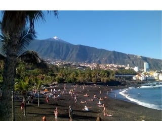
Imágenes paisajes turísticos
•Descargar como ODP, PDF•
0 recomendaciones•7,978 vistas
Paisajes turísticos
Denunciar
Compartir
Denunciar
Compartir

Recomendados
Unit 11. socioeconomic inequalities
This document discusses socioeconomic inequalities and global conflicts. It begins by explaining how inequalities are measured using indicators like GDP, GDP per capita, the Human Development Index, and Multidimensional Poverty Index. It then analyzes the causes of development inequalities, including domestic factors like lack of resource exploitation as well as international factors like colonialism and unequal trading relationships. The document also evaluates recent trends in global inequalities and discusses specific issues around inequalities in Europe and Spain. It concludes by examining proposed solutions to human development issues through increasing economic aid, improving human development, and greater citizen participation.
Habsburg dinasty
The document discusses the history of Spain during the Modern Age, beginning in 1580 under King Felipe II of the Habsburg dynasty. It describes how the Catholic Monarchs Isabel and Fernando unified the territories of Castile and Aragon in the late 15th century. Their grandson Carlos I expanded the empire through wars with France and the Ottoman Empire. Felipe II maintained Catholicism and fought conflicts against England, France, and a revolt in the Low Countries. The Spanish Empire began to decline in the 17th century under the later Habsburg kings Felipe III and Felipe IV as over-taxation sparked domestic revolts while wars drained the treasury.
Habsburg dinasty
The document discusses the modern age in Spain from 1580-1700. It summarizes the reigns of several Spanish monarchs during this period including Charles I, Philip II, Philip III, Philip IV, and Charles II. Key events included the territorial unification of Spain, wars with France and the Ottoman Empire, the Spanish Armada against England, revolts in the Low Countries and Portugal, and the gradual decline of the Habsburg dynasty's control over its vast empire in this period.
LOS PUEBLOS PRECOLOMBINOS
Este documento resume la llegada de los primeros pueblos al continente americano hace aproximadamente 40,000 años a través del estrecho de Bering, y describe las principales culturas precolombinas que existían en las áreas mesoamericana y andina, incluyendo los mayas, aztecas e incas. Explica aspectos clave de la organización social, política, económica y cultural de estas civilizaciones, así como las consecuencias de los descubrimientos europeos en el mundo.
Ancient greece
Greece is located in Southeastern Europe, between the Ionian and Aegean Seas. The ancient Greek civilization developed across mountainous terrain and along coastlines. Greece comprised independent city-states called poleis that never formed a unified state. During the Archaic period, the Greeks established colonies across the Mediterranean and Black Seas. The Classical period saw the Greco-Persian wars and Peloponnesian wars between Athens and Sparta. Alexander the Great later conquered the Persian Empire and expanded Greek rule throughout Europe and Asia. Greek culture flourished through advances in architecture, art, philosophy, and the establishment of democracy in some poleis.
Ancient greece
Greece is located in Southeast Europe, bordering the Aegean and Ionian seas between the Balkans and Asia Minor. In ancient times, the Greek civilization developed across mountainous terrain in Greece and along the surrounding coasts. The Ancient Greeks lived in independent city-states called poleis, with no unified Greek state. During the Archaic period, Greeks established colonies across the Mediterranean and Black seas due to overpopulation and shortage of land at home. The Classical period saw the rise of Athens and Sparta as the most powerful poleis, and their rivalry led to the Peloponnesian wars in the 5th century BC. Alexander the Great later conquered the Persian Empire and much of Asia Minor and Southwest Asia
Ancient greece
Greece is located in Southeast Europe, with territory in the Mediterranean, Aegean, and Ionian seas. The ancient Greek civilization developed across mountainous and coastal terrain in this region. Greece was not a unified state but consisted of independent city-states called poleis such as Athens and Sparta. During the Archaic period from the 8th to 6th centuries BC, the poleis expanded through colonization across the Mediterranean and Black seas. This led to the spread of Greek culture and trade. In the Classical period from 550-336 BC, the Greco-Persian wars resulted in Greek victories that secured independence. However, tensions later erupted into the Peloponnesian war between Athens-led and Sparta-
Unit egypt
Egypt is located in northern Africa along the Nile River valley. The ancient Egyptian civilization flourished here due to the fertile soil provided by annual flooding of the Nile. Egyptian society was highly stratified, with pharaohs and nobles at the top ruling over priests, skilled workers, and farmers. Farming and irrigation systems developed along the Nile allowed Egyptians to produce surplus crops, supporting large cities and advancement in other areas. Egyptian religion was polytheistic and involved mummification of the dead and judgment of the soul in the afterlife.
The modern age
The document discusses the Middle Ages and the transition to the Modern Age across Europe from the 15th to 18th centuries. It covers several key events and developments, including the Protestant Reformation led by figures like Martin Luther and John Calvin; the Age of Discovery including Columbus' voyage to the Americas in 1492; the rise of strong monarchies and nation-states; and economic and social changes associated with the decline of feudalism and growth of trade and capitalism. The Ottoman Empire's control of the Mediterranean is cited as a factor driving European exploration of new trade routes.
Edad moderna
El documento resume los principales cambios políticos, económicos, sociales y culturales entre la Edad Media y la Edad Moderna. Políticamente, los monarcas adquirieron más poder sobre los nobles. La economía cambió a ser comercial. Culturalmente, hubo un cambio del teocentrismo al antropocentrismo con el Renacimiento y el desarrollo de las artes. Los descubrimientos geográficos llevaron a la globalización.
Unit egypt
Ancient Egypt was located in the fertile valley of the Nile River in Northeast Africa. The Nile provided water for irrigation and transportation, enabling the rise of the Egyptian civilization. Egyptian society was highly stratified, with pharaohs and nobles at the top. Farming and trade supported the population, and complex irrigation systems were developed. The Egyptian religion was polytheistic, with many gods represented with animal heads. After death, people faced judgment by Osiris to determine if they could reach the afterlife.
The modern age
The document discusses the Middle Ages and the transition to the Modern Age across Europe from the 15th to 18th centuries. It describes the rise of authoritarian monarchies and the modern state, driven by factors like geographical discoveries, the Protestant Reformation, and the development of new trade routes. It also summarizes the political, economic, and social changes during this period, including the growth of merchant classes, decline of feudal systems, and religious conflicts between Catholic and Protestant faiths.
Tema 10 org territ ii
El documento describe la evolución de la organización político-administrativa de España. Se detalla la división provincial establecida por Javier de Burgos en 1833 y la constitución de 1978 que establece el estado de las autonomías. También analiza los desequilibrios territoriales en España, sus causas e indicadores, así como la política regional de la Unión Europea y la política de cohesión territorial del estado español.
Tema+7 a+cidade+-+valencia
Valencia ha experimentado un crecimiento urbano desde su origen romano hasta convertirse en una gran ciudad moderna. Su morfología urbana incluye el casco antiguo irregular dentro de las murallas, el ensanche del siglo XIX con plano de cuadrícula, y una extensa periferia residencial e industrial del siglo XX. La ciudad también alberga importantes funciones administrativas y turísticas.
Urbanismo tema 9
El documento describe el concepto de ciudad y el proceso de urbanización en España a lo largo de la historia. Se divide la urbanización en tres etapas: preindustrial, industrial y postindustrial. En la etapa preindustrial, las ciudades eran pequeñas y amuralladas. La industrialización impulsó un fuerte crecimiento urbano. Actualmente, las ciudades siguen creciendo pero a menor ritmo debido al declive de la industria y el envejecimiento de la población. También se explican conceptos como la morfología, e
Mesopotamia
Mesopotamia was located between the Tigris and Euphrates Rivers in modern Iraq. For over 3000 years beginning around 3500 BC, various civilizations developed in this region, including the Sumerians, Akkadians, Babylonians, Assyrians, and Persians. Mesopotamian cities like Ur and Uruk featured innovations like irrigation systems, writing, and architecture using arches, vaults, and ziggurats. Society was organized around religion, with kings and priests governing as intermediaries between the people and the gods like Anu, Enki, Enlil, Ishtar, and Marduk. Mesopotamian culture left behind artistic works, legal
Mesopotamia
Mesopotamia was located between the Tigris and Euphrates Rivers in modern-day Iraq. This civilization began around 3500 BC and lasted for over 3000 years, during which several empires and city-states rose and fell. Some influential cities included Ur, Uruk, Akkad, Babylon, and Nineveh. The Mesopotamians were among the first to develop irrigation for agriculture, writing, law codes, and architectural techniques like the arch and vault. Power was held by rulers of the city-states and later empires, including the Sumerians, Akkadians, Babylonians, and Assyrians. The Mesopotamian civilization marked many important advances and innovations
Unit 6. the secondary sector
The document summarizes key aspects of the secondary sector, which includes industries that transform raw materials into goods. It describes the main activities in the secondary sector as industry, mining, energy production, and construction. Industry transforms raw materials into manufactured products or semi-finished products using raw materials, energy sources, and production factors. Mining locates, extracts, and refines rocks and minerals. Energy production transforms energy sources into heat and electricity. Construction creates buildings and infrastructure using plans and building materials. The document also discusses raw materials production, consumption, and problems related to scarcity. It notes that offshoring has moved many industries to developing countries with lower labor costs.
Unit 6. the secondary sector
The secondary sector includes activities that transform raw materials into products, including industry, mining, energy production, and construction. Industry transforms raw materials into manufactured goods using energy sources and production factors. Mining locates, extracts, and refines minerals from the earth. Energy production transforms energy sources like natural gas into electricity. Construction creates buildings and infrastructure using plans and building materials. The main producing countries of raw materials are Canada, Australia, Russia, Brazil, South Africa, the US, and China. The largest consumers are Western Europe, the US, Japan, China, and India.
Prehistory
The document provides information about prehistory through a series of questions and prompts. It covers major topics like the Paleolithic, Neolithic, and Metal Ages. Key details include a timeline of prehistoric eras defined by tool use (Paleolithic, Neolithic, Metal Ages), how archaeology informs our understanding of prehistory through excavated materials and human remains, evidence of human evolution from primates, and daily life during the Paleolithic focused on hunting and gathering and use of early stone tools.
Tema 8 población (1ª parte)
La población española se caracteriza por tener una distribución desigual entre las diferentes comunidades autónomas, con mayores densidades en las zonas urbanas y costeras. El crecimiento natural de la población es bajo debido a las bajas tasas de natalidad y fecundidad, aunque la esperanza de vida es alta. Históricamente, España ha pasado por diferentes regímenes demográficos, con altas tasas de natalidad y mortalidad en el pasado y una transición demográfica en el siglo XX hacia tasas más bajas
Environmental problems para subir
The document outlines an environmental problems project. Students will work in groups to research, identify, and present on an environmental issue. They must analyze the problem, causes, environmental consequences, solutions, most impacted locations, and relevant laws. Presentations should have a digital format with visuals like photos, videos, and maps. Students will work on their projects in the computer lab and at home before presenting their findings to the class.
Guion comentario-paisaje-turistico-benidormx
El documento describe el paisaje turístico de Benidorm, localizado en Alicante, España. Detalla las características del lugar como rascacielos, hoteles, playas y atracciones turísticas que lo convierten en un destino popular para visitantes nacionales e internacionales.
Tema 7 el sector terciario 2º bach
Este documento describe los principales aspectos del sector terciario en España. Explica que desde la década de 1960 España ha experimentado un proceso de terciarización en el que el sector terciario se ha convertido en el más importante en términos de contribución al PIB y empleo. Describe las características clave del sector terciario español, incluidos los transportes, las telecomunicaciones y el turismo, que es una de las actividades terciarias más importantes en términos económicos.
Unit 5
The document provides information on agrarian spaces and activities in the primary sector. It defines agrarian spaces as land where agrarian activities like agriculture, livestock farming, and silviculture take place. Agrarian activities are influenced by natural factors like climate, soil type, and relief, as well as human factors such as technology, population levels, and economic organization. The types of agrarian landscapes and activities can vary significantly based on these influencing factors.
Tema 6 indust
Este documento trata sobre las materias primas y fuentes de energía en España. Resume que las materias primas son los recursos naturales que la industria transforma, incluyendo recursos orgánicos e inorgánicos. Explica las principales fuentes de energía como los combustibles fósiles (carbón, petróleo y gas natural), la energía nuclear, e hidroeléctrica y otras energías renovables como la solar y eólica. Finalmente, discute los principales problemas energéticos de España como su alta dependencia de importaciones de energía y
Modelo de comentario de gráfico
Este documento describe los pasos para comentar un gráfico y proporciona ejemplos de diferentes tipos de gráficos. Explica que un comentario de gráfico debe incluir la clasificación del gráfico, un análisis de los datos, una discusión del contexto histórico y una conclusión. Además, provee un ejemplo completo de cómo comentar un gráfico lineal sobre la producción industrial en España entre 1855 y 1975.
The climate and bioclimte zones
This document discusses climate and weather concepts. It defines weather as short-term atmospheric conditions while climate refers to weather patterns over a long period, usually 30 years. The key elements that determine climate differences are temperature, precipitation, atmospheric pressure, and wind. Different combinations of these elements result in various climate zones on Earth such as equatorial, tropical, Mediterranean, oceanic, continental, polar, desert, and mountain climates. Bioclimates represent the combination of climate and natural vegetation in a particular region.
Lecciones 11 Esc. Sabática. El conflicto inminente docx
El conflicto en el fin del tiempo será sobre la adoración.
Más contenido relacionado
Más de mmm-g
The modern age
The document discusses the Middle Ages and the transition to the Modern Age across Europe from the 15th to 18th centuries. It covers several key events and developments, including the Protestant Reformation led by figures like Martin Luther and John Calvin; the Age of Discovery including Columbus' voyage to the Americas in 1492; the rise of strong monarchies and nation-states; and economic and social changes associated with the decline of feudalism and growth of trade and capitalism. The Ottoman Empire's control of the Mediterranean is cited as a factor driving European exploration of new trade routes.
Edad moderna
El documento resume los principales cambios políticos, económicos, sociales y culturales entre la Edad Media y la Edad Moderna. Políticamente, los monarcas adquirieron más poder sobre los nobles. La economía cambió a ser comercial. Culturalmente, hubo un cambio del teocentrismo al antropocentrismo con el Renacimiento y el desarrollo de las artes. Los descubrimientos geográficos llevaron a la globalización.
Unit egypt
Ancient Egypt was located in the fertile valley of the Nile River in Northeast Africa. The Nile provided water for irrigation and transportation, enabling the rise of the Egyptian civilization. Egyptian society was highly stratified, with pharaohs and nobles at the top. Farming and trade supported the population, and complex irrigation systems were developed. The Egyptian religion was polytheistic, with many gods represented with animal heads. After death, people faced judgment by Osiris to determine if they could reach the afterlife.
The modern age
The document discusses the Middle Ages and the transition to the Modern Age across Europe from the 15th to 18th centuries. It describes the rise of authoritarian monarchies and the modern state, driven by factors like geographical discoveries, the Protestant Reformation, and the development of new trade routes. It also summarizes the political, economic, and social changes during this period, including the growth of merchant classes, decline of feudal systems, and religious conflicts between Catholic and Protestant faiths.
Tema 10 org territ ii
El documento describe la evolución de la organización político-administrativa de España. Se detalla la división provincial establecida por Javier de Burgos en 1833 y la constitución de 1978 que establece el estado de las autonomías. También analiza los desequilibrios territoriales en España, sus causas e indicadores, así como la política regional de la Unión Europea y la política de cohesión territorial del estado español.
Tema+7 a+cidade+-+valencia
Valencia ha experimentado un crecimiento urbano desde su origen romano hasta convertirse en una gran ciudad moderna. Su morfología urbana incluye el casco antiguo irregular dentro de las murallas, el ensanche del siglo XIX con plano de cuadrícula, y una extensa periferia residencial e industrial del siglo XX. La ciudad también alberga importantes funciones administrativas y turísticas.
Urbanismo tema 9
El documento describe el concepto de ciudad y el proceso de urbanización en España a lo largo de la historia. Se divide la urbanización en tres etapas: preindustrial, industrial y postindustrial. En la etapa preindustrial, las ciudades eran pequeñas y amuralladas. La industrialización impulsó un fuerte crecimiento urbano. Actualmente, las ciudades siguen creciendo pero a menor ritmo debido al declive de la industria y el envejecimiento de la población. También se explican conceptos como la morfología, e
Mesopotamia
Mesopotamia was located between the Tigris and Euphrates Rivers in modern Iraq. For over 3000 years beginning around 3500 BC, various civilizations developed in this region, including the Sumerians, Akkadians, Babylonians, Assyrians, and Persians. Mesopotamian cities like Ur and Uruk featured innovations like irrigation systems, writing, and architecture using arches, vaults, and ziggurats. Society was organized around religion, with kings and priests governing as intermediaries between the people and the gods like Anu, Enki, Enlil, Ishtar, and Marduk. Mesopotamian culture left behind artistic works, legal
Mesopotamia
Mesopotamia was located between the Tigris and Euphrates Rivers in modern-day Iraq. This civilization began around 3500 BC and lasted for over 3000 years, during which several empires and city-states rose and fell. Some influential cities included Ur, Uruk, Akkad, Babylon, and Nineveh. The Mesopotamians were among the first to develop irrigation for agriculture, writing, law codes, and architectural techniques like the arch and vault. Power was held by rulers of the city-states and later empires, including the Sumerians, Akkadians, Babylonians, and Assyrians. The Mesopotamian civilization marked many important advances and innovations
Unit 6. the secondary sector
The document summarizes key aspects of the secondary sector, which includes industries that transform raw materials into goods. It describes the main activities in the secondary sector as industry, mining, energy production, and construction. Industry transforms raw materials into manufactured products or semi-finished products using raw materials, energy sources, and production factors. Mining locates, extracts, and refines rocks and minerals. Energy production transforms energy sources into heat and electricity. Construction creates buildings and infrastructure using plans and building materials. The document also discusses raw materials production, consumption, and problems related to scarcity. It notes that offshoring has moved many industries to developing countries with lower labor costs.
Unit 6. the secondary sector
The secondary sector includes activities that transform raw materials into products, including industry, mining, energy production, and construction. Industry transforms raw materials into manufactured goods using energy sources and production factors. Mining locates, extracts, and refines minerals from the earth. Energy production transforms energy sources like natural gas into electricity. Construction creates buildings and infrastructure using plans and building materials. The main producing countries of raw materials are Canada, Australia, Russia, Brazil, South Africa, the US, and China. The largest consumers are Western Europe, the US, Japan, China, and India.
Prehistory
The document provides information about prehistory through a series of questions and prompts. It covers major topics like the Paleolithic, Neolithic, and Metal Ages. Key details include a timeline of prehistoric eras defined by tool use (Paleolithic, Neolithic, Metal Ages), how archaeology informs our understanding of prehistory through excavated materials and human remains, evidence of human evolution from primates, and daily life during the Paleolithic focused on hunting and gathering and use of early stone tools.
Tema 8 población (1ª parte)
La población española se caracteriza por tener una distribución desigual entre las diferentes comunidades autónomas, con mayores densidades en las zonas urbanas y costeras. El crecimiento natural de la población es bajo debido a las bajas tasas de natalidad y fecundidad, aunque la esperanza de vida es alta. Históricamente, España ha pasado por diferentes regímenes demográficos, con altas tasas de natalidad y mortalidad en el pasado y una transición demográfica en el siglo XX hacia tasas más bajas
Environmental problems para subir
The document outlines an environmental problems project. Students will work in groups to research, identify, and present on an environmental issue. They must analyze the problem, causes, environmental consequences, solutions, most impacted locations, and relevant laws. Presentations should have a digital format with visuals like photos, videos, and maps. Students will work on their projects in the computer lab and at home before presenting their findings to the class.
Guion comentario-paisaje-turistico-benidormx
El documento describe el paisaje turístico de Benidorm, localizado en Alicante, España. Detalla las características del lugar como rascacielos, hoteles, playas y atracciones turísticas que lo convierten en un destino popular para visitantes nacionales e internacionales.
Tema 7 el sector terciario 2º bach
Este documento describe los principales aspectos del sector terciario en España. Explica que desde la década de 1960 España ha experimentado un proceso de terciarización en el que el sector terciario se ha convertido en el más importante en términos de contribución al PIB y empleo. Describe las características clave del sector terciario español, incluidos los transportes, las telecomunicaciones y el turismo, que es una de las actividades terciarias más importantes en términos económicos.
Unit 5
The document provides information on agrarian spaces and activities in the primary sector. It defines agrarian spaces as land where agrarian activities like agriculture, livestock farming, and silviculture take place. Agrarian activities are influenced by natural factors like climate, soil type, and relief, as well as human factors such as technology, population levels, and economic organization. The types of agrarian landscapes and activities can vary significantly based on these influencing factors.
Tema 6 indust
Este documento trata sobre las materias primas y fuentes de energía en España. Resume que las materias primas son los recursos naturales que la industria transforma, incluyendo recursos orgánicos e inorgánicos. Explica las principales fuentes de energía como los combustibles fósiles (carbón, petróleo y gas natural), la energía nuclear, e hidroeléctrica y otras energías renovables como la solar y eólica. Finalmente, discute los principales problemas energéticos de España como su alta dependencia de importaciones de energía y
Modelo de comentario de gráfico
Este documento describe los pasos para comentar un gráfico y proporciona ejemplos de diferentes tipos de gráficos. Explica que un comentario de gráfico debe incluir la clasificación del gráfico, un análisis de los datos, una discusión del contexto histórico y una conclusión. Además, provee un ejemplo completo de cómo comentar un gráfico lineal sobre la producción industrial en España entre 1855 y 1975.
The climate and bioclimte zones
This document discusses climate and weather concepts. It defines weather as short-term atmospheric conditions while climate refers to weather patterns over a long period, usually 30 years. The key elements that determine climate differences are temperature, precipitation, atmospheric pressure, and wind. Different combinations of these elements result in various climate zones on Earth such as equatorial, tropical, Mediterranean, oceanic, continental, polar, desert, and mountain climates. Bioclimates represent the combination of climate and natural vegetation in a particular region.
Más de mmm-g (20)
Último
Lecciones 11 Esc. Sabática. El conflicto inminente docx
El conflicto en el fin del tiempo será sobre la adoración.
Gracias papá voz mujer_letra y acordes de guitarra.pdf
Puedes encontrar el video y el archivo para descargar en mi blog:
https://labitacoradeann.blogspot.com/2024/06/gracias-papa.html
MATERIAL ESCOLAR 2024-2025. 4 AÑOS CEIP SAN CRISTOBAL
MATERIAL ESCOLAR 2024-2025. 4 AÑOS CEIP SAN CRISTOBAL
FEEDBACK DE LA ESTRUCTURA CURRICULAR- 2024.pdf
José Luis Jiménez Rodríguez
Junio 2024.
“La pedagogía es la metodología de la educación. Constituye una problemática de medios y fines, y en esa problemática estudia las situaciones educativas, las selecciona y luego organiza y asegura su explotación situacional”. Louis Not. 1993.
CINE COMO RECURSO DIDÁCTICO para utilizar en TUTORÍA
Dos cortos y ocho películas para tratar en el aula.
CONCURSOS EDUCATIVOS 2024-PRESENTACIÓN ORIENTACIONES ETAPA IE (1).pptx
Desripción de concursos educativos 2024
Manual de procedimiento para gráficos HC
Manual de usuario para elaborar gráficos en Hoja de cálculo de Google.
DESARROLLO DE LAS RELACIONES CON LOS STAKEHOLDERS.pdf
DESARROLLO DE LAS RELACIONES CON LOS STAKEHOLDERS
Business Plan -rAIces - Agro Business Tech
Innovación y transparencia se unen en un nuevo modelo de negocio para transformar la economia popular agraria en una agroindustria. Facilitamos el acceso a recursos crediticios, mejoramos la calidad de los productos y cultivamos un futuro agrícola eficiente y sostenible con tecnología inteligente.
Soluciones Examen de Selectividad. Geografía junio 2024 (Convocatoria Ordinar...
Criterios de corrección y soluciones al examen de Geografía de Selectividad (EvAU) Junio de 2024 en Castilla La Mancha.
Soluciones al examen.
Convocatoria Ordinaria.
Examen resuelto de Geografía
conocer el examen de geografía de julio 2024 en:
https://blogdegeografiadejuan.blogspot.com/2024/06/soluciones-examen-de-selectividad.html
http://blogdegeografiadejuan.blogspot.com/
Último (20)
Lecciones 11 Esc. Sabática. El conflicto inminente docx
Lecciones 11 Esc. Sabática. El conflicto inminente docx
Gracias papá voz mujer_letra y acordes de guitarra.pdf
Gracias papá voz mujer_letra y acordes de guitarra.pdf
MATERIAL ESCOLAR 2024-2025. 4 AÑOS CEIP SAN CRISTOBAL
MATERIAL ESCOLAR 2024-2025. 4 AÑOS CEIP SAN CRISTOBAL
Evaluacion-Formativa-Nueva Escuela Mexicana NEM-ok.pdf
Evaluacion-Formativa-Nueva Escuela Mexicana NEM-ok.pdf
La vida de Martin Miguel de Güemes para niños de primaria
La vida de Martin Miguel de Güemes para niños de primaria
Presentación de proyecto en acuarela moderna verde.pdf
Presentación de proyecto en acuarela moderna verde.pdf
CINE COMO RECURSO DIDÁCTICO para utilizar en TUTORÍA
CINE COMO RECURSO DIDÁCTICO para utilizar en TUTORÍA
CONCURSOS EDUCATIVOS 2024-PRESENTACIÓN ORIENTACIONES ETAPA IE (1).pptx
CONCURSOS EDUCATIVOS 2024-PRESENTACIÓN ORIENTACIONES ETAPA IE (1).pptx
DESARROLLO DE LAS RELACIONES CON LOS STAKEHOLDERS.pdf
DESARROLLO DE LAS RELACIONES CON LOS STAKEHOLDERS.pdf
Eureka 2024 ideas y dudas para la feria de Ciencias
Eureka 2024 ideas y dudas para la feria de Ciencias
Soluciones Examen de Selectividad. Geografía junio 2024 (Convocatoria Ordinar...
Soluciones Examen de Selectividad. Geografía junio 2024 (Convocatoria Ordinar...