Descargar para leer sin conexión


![E T
l Istituto Europeo di Design celebra con Mapping Madrid su participación en he Istituto Europeo di Design has taken part in PhotoEspaña for the third consecutive
PHotoEspaña por tercer año consecutivo. De esta forma, junto a otras actividades year, with Mapping Madrid. In this way, along with other activities, such as La mirada
como La mirada mágica, confirma y refuerza su apuesta por las artes visuales y mágica [The Magical Gaze], it confirmed and strengthened its commitment to the
muy especialmente por la fotografía –máxime en este año académico en el que nuestro visual arts and more especially to photography –particularly in this academic year, which saw
curso de fotografía ha iniciado su andadura–, puesto que este medio es, sin duda, uno de the beginning of our photography course–, given that this medium is, undoubtedly, one of
los modos privilegiados de comunicación en el mundo contemporáneo, dominado clara- the principal means of communication in the modern world, which is clearly dominated by
mente por la imagen como forma más poderosa de construir los relatos de nuestros días. the image as the most powerful way of constructing the stories of our times.
Si el primer año dentro de PHotoEspaña la exposición de Alberto Corazón permitió que The first year in which PHotoEspaña took place, the exhibition of the work by Alberto
nos acercásemos a piezas míticas de la Transición política de la España democrática, al Corazón allowed us to get nearer to mythical pieces from the political transition of demo-
tiempo que permitía observar el paso de conductas conceptuales a procesos editoriales cratic Spain, while also enabling us to observe the change from conceptual behaviours to
que hoy día son corrientes; el año pasado se vio confirmada esa necesidad de reivindicar editorial processes which are common today. Last year, on the other hand, saw the confirma-
una tradición del diseño, las artes y la comunicación a través de una muestra que contó tion of the need to claim a tradition in design, the arts and communication by way of an ex-
con protagonistas tan conocidos como Nobuyoshi Araki, Joseph Beuys, Daniele Buetti, hibition featuring such well-known artists as Nobuyoshi Araki, Joseph Beuys, Daniele Buetti,
Cabello/Carceller, Alfredo Jaar, Thomas Ruff, Montserrat Soto o Erwin Wurm. Cabello/Carceller, Alfredo Jaar, Thomas Ruff, Montserrat Soto and Erwin Wurm.
En 2009 el IED ha querido dar un paso más, en sintonía con la propia evolución de la insti- In 2009 the IED wanted to go a step further, in harmony with the evolution of the institution
tución, tras consolidar un programa cultural continuo y concebir su propuesta didáctica y itself, following the consolidation of a continuous cultural programme, and planned its di-
cultural como un gran laboratorio, que crece gracias a la aportación de todos aquellos que dactic and cultural proposal as a great laboratory, which would grow thanks to the contribu-
demuestran su pasión por la creatividad. El Palacio de Altamira e IED Master se ofrecen, tion of all those who could demonstrate their passion for creativity. The Palacio de Altamira
pues, como puntos de encuentro y qué mejor manera de demostrarlo que idear un proyec- and IED Master are therefore acting as meeting points, and what better way to demonstrate
to que reflexiona sobre el propio festival en el que se encuentra la exposición, invitando a this than by devising a project that reflects on the very festival in which the exhibition is on
ofrecer distintos puntos de vista sobre el mismo. display, welcoming different points of view on the subject.
En este caso, gracias a Mapping Madrid se activa un proceso cuyo mayor interés reside In this case, thanks to Mapping Madrid, we activated a process whose greatest interest lay precise-
precisamente en la colaboración de todas aquellas personas que han decidido participar ly in the collaboration of all those who had decided to take part in a common project. As a whole,
en un proyecto común. En su conjunto, el resultado ha sido muy satisfactorio, puesto que the result was very satisfactory, given that it has permitted an examination of the ways of repre-
ha permitido reflexionar sobre formas de representación del mundo, como es el mapa, senting the world, such as the map, in order to discover the subjectivities which lie behind them
para descubrir las subjetividades que hay detrás de todas ellas, pero sobre todo, las distin- all, but above all, of the different perspectives that exist to make the place where we live visible.
tas perspectivas que existen para hacer visible el lugar donde vivimos.
And all this has been possible thanks to a firm and appropriate commitment to the new
Y todo ello ha sido posible gracias a una fuerte y pertinente apuesta por nuevos medios y media and formats, which enable us to promote one of the key features of the IED: whoever
formatos, que permiten potenciar una característica clave del IED: quien está dentro de él comes across the show should not be a mere spectator, but an active part of what is happen-
no debe ser un mero espectador, sino una parte activa de lo que ocurre en su interior. Así, ing. In this way, a project takes shape, which has managed, with today’s resources, to con-
cobra forma un proyecto que ha logrado construir con medios actuales una nueva visión struct a new vision of what it means to make a map, in this case, of the city which has been
de lo que significa hacer un mapa, en este caso de la ciudad que acoge al IED desde hace home to the IED for fifteen years, and from which it is possible to offer other ways of learning
quince años y desde la que es posible ofrecer otras formas de conocer la cultura del proyecto. about the culture of the project.
Riccardo Marzullo Riccardo Marzullo
Director del IED Madrid Director of the IED Madrid
10 11](https://image.slidesharecdn.com/2347886/85/CATALOGO-DE-MAPPING-MADRID-6-320.jpg)


![Objetividad y representación
Cartografías de la realidad
portamientos fotográficos”, procedentes de
Realizar un mapa no ha sido históricamente prácticas artísticas alejadas del uso purista del
una tarea neutra, siempre conlleva una mira- medio en las vanguardias artísticas –como es
Mirada, fotografía y mapa da. Todo mapa ha surgido como consecuencia
de una determinada ideología o bajo criterios
el caso de Man Ray–, pero sobre todo en aque-
llas manifestaciones conceptuales de los años
Pedro Medina con frecuencia arbitrarios que condicionan sesenta, que suponían un paso más dentro de
las formas de representar el mundo. esa polémica en torno al estatuto artístico de la
fotografía latente prácticamente desde sus orí-
En esta ocasión, el diseño de una cartografía genes, debido a su carácter no aurático, deriva-
se liga a un medio: la fotografía, tan subjetiva do de su reproductibilidad, y de esa supuesta
como cualquier otro lenguaje artístico, pero objetividad mayor que otros medios privilegia-
que popularmente se identifica con un medio dos todavía por creencias de tipo romántico.
que documenta el mundo como mayor obje-
tividad que otros. Al hacerlo, pronto surge la Su uso documental para registrar obras de
tradicional cuestión de fondo sobre la rela- arte efímeras, junto con las expresiones
ción entre objetividad y realidad. conceptuales, transformó a la fotografía en
un medio para la experimentación que daba
Estas consideraciones aún lastran diagnós- lugar a nuevas formas y prácticas, así como
ticos sobre un lenguaje que era emergente, a una reflexión sobre la misma fotografía y
como aquellos maravillosos textos de Walter su rol respecto a la sociedad y el arte, con-
Benjamin en los que reflexionaba sobre cómo virtiéndose en el camino para alzar la idea a
duplicar el mundo, retratándolo con mayor la categoría de objeto, al tiempo que el lugar
fidedignidad. Benjamin llegó a hablar de un idóneo para prácticas escenográficas nue-
“museo imaginario” basado en la afirmación vas, aunque su principal papel seguía siendo
de Godard a propósito de Le Carabiniers: “co- como medio.
leccionar fotografías es coleccionar el mundo”.
Sin embargo, los nuevos comportamientos Pero dejando de lado la relevante aparición
artísticos han transformado esta función, pa- de una “nueva forma artística”, que procede
sando a reflejar irónicamente el mundo o a de la crisis de los géneros artísticos tradicio-
constatar “la irrealidad de la realidad” –como nales, y que encuentra precisamente en la
afirmaba Kate Linker–. Obviamente, estas nue- fotografía un campo idóneo para desarrollar
vas prácticas encuentran cabida en evidentes las potencialidades icónicas de la imagen, en
revisiones del problema de la representación. el contexto de esta exposición se privilegia
su dimensión como documento o archivo de
Un muy breve balance de lo ocurrido desde el la realidad.
asentamiento de la fotografía dentro del siste-
“El mapa es abierto, es conectable en todas sus dimensiones, ma del arte a mediados de los ochenta, destaca La propuesta de Mapping Madrid enlazaría
desmontable, reversible, susceptible de recibir constantemente principalmente la reivindicación “artística” de con posturas que fomentan la procesualidad
modificaciones […] Haced mapas y no fotos ni dibujos” la fotografía documental y el asentimiento misma, como fenómeno de representación
(Gilles Deleuze y Felix Guattari, Rizoma) de lo que podría denominarse “nuevos com- y como constancia de aquellas manifesta-
26 Mapping Madrid · IED Madrid & PHE09 Mapping Madrid · IED Madrid & PHE09 27](https://image.slidesharecdn.com/2347886/85/CATALOGO-DE-MAPPING-MADRID-14-320.jpg)
![ciones de carácter temporal condenadas a propio espacio físico. Ante este hecho, cabe mapas desata potencialidades, rehace el terri- muestra suficientemente contrastada, no obs-
desaparecer o que se conciben precisamente preguntarse ¿cómo representar entonces torio una y otra vez, cada vez con nuevas y tante, sí parece coincidir con buena parte de
en su estar in progress. Es, pues, el lenguaje esta realidad? diferentes consecuencias”. reconocidos diagnósticos de nuestra época.
fundamental y el instrumento que constata Remontándonos un poco en el tiempo, po-
lo ocurrido. “Realizar un mapa no ¿Y cómo se produce esto hoy día? Quizás con dríamos hablar de la sentencia de Nietzsche
ha sido históricamente los nuevos medios se pueda dar esa feliz co- en su paradigmático Der Fall Wagner, donde
A la consustancial reproducción mecánica
implícita en el propio concepto de fotogra-
una tarea neutra, incidencia de mapa e imperio –diría Borges
en el famoso relato sobre el Arte de la Carto-
toda décadence literaria está caracterizada
por una condición: “la vida ya no habita en el
fía, lo que facilita la recepción masiva de la siempre conlleva una grafía–, de georrepresentación y cosmovisión todo”. Extraemos de Nietzsche y de todos sus
obra y la democratización de su producción, mirada. Todo mapa podríamos decir nosotros. epígonos que la realidad se vuelve fragmen-
ahora aparece la posibilidad de la utilización ha surgido como taria, constatando que no hay un valor central
de nuevos medios, más proclives a la interac-
ción y la creación de piezas colectivas, donde
consecuencia de una Esta situación debería llevarnos a un posicio-
namiento que impida que sucumbamos a la
en la época que le dé sentido, como ocurría,
por ejemplo, en la Edad Media, donde el dios
la participación se vuelve algo natural en esa determinada ideología fascinación por la forma expresiva, estable- cristiano era medida de todas las cosas y el
transformación del espectador en usuario, lo o bajo criterios con ciendo un mínimo análisis sobre el mundo en gótico o el románico eran las formas que ha-
que aporta un enriquecedor poliperspectivis- frecuencia arbitrarios el que vivimos para preguntarnos ¿por qué cían visible una relación homogénea y unívo-
mo. De esta forma, esa característica de ima-
gen multiplicable adquiere ahora una dimen-
que condicionan las acudimos a este tipo de representación?, ¿es
pertinente para poder hablar sobre la expe-
ca con el mundo.
sión mayor, al mismo tiempo que se potencia formas de representar riencia de nuestra época? Parece coherente “La propuesta de
una relación de pertenencia con la obra que el mundo” con los tiempos que corren alejarse de postu- Mapping Madrid
tiene más que ver con la colaboración en el ras que adopten el autoritarismo que profesa
proceso y la emoción activada en el mismo Jean Baudrillard parte precisamente de quien cree en una verdad y pensar más bien
enlazaría con posturas
que con la posesión física de la obra. la cartografía como paradigma de una re- en un mundo lábil, donde todo se vuelve po- que fomentan la
ferencialidad perdida, llegando incluso a sibilidad y no necesidad. procesualidad misma,
Por otro lado, nos encontramos con el mapa afirmar en Cultura y simulacro que “el terri- como fenómeno
como un formato que también se percibe torio ya no precede al mapa ni le sobrevive. A pie de calle, enseguida aparecen términos
ingenuamente como algo objetivo, pero que En adelante será el mapa el que preceda al coincidentes como “global, tecnificado, acele-
de representación y
–como aparece al inicio de este texto y sobre territorio –precisión de los simulacros– y el rado, injusto, en el que nada permanece, sin como constancia de
todo en ¿Para qué un mapa? de Pablo Jarau- que lo engendre”. valores…”, aunque se puede resumir como un aquellas manifestaciones
ta– conviene observar como otro medio más mundo marcado por la comunicación plane- de carácter temporal
para contar una historia y hacer evidentes Al respecto, conviene recordar las matiza- taria, más que sin valores, en construcción
formas de ver el mundo. ciones que realizaba André Corboz en El te- hacia otros nuevos (sostenibilidad, igualdad
condenadas a
rritorio como palimpsesto, al comparar dos de géneros y razas…) y, sobre todo, un mun- desaparecer”
Al margen del relato construido por Pablo maneras de relacionarse con el territorio (la do que ha devenido moda, es decir, donde ni
Jarauta, quisiera aportar un par de notas, contemplación del paisaje y el mapa): “El convicciones, ni instituciones, ni productos Por otro lado, partiendo del análisis de la ciu-
sobre todo para establecer su relación con mapa se diferencia del territorio precisamen- están dados de una vez para siempre, siendo dad como la gran forma de rastrear la vida
el ámbito de la ciudad, un contexto en el te a través de actos de selección. Como prác- el reino de lo efímero. –en la línea de Georg Simmel–, destaca un
que se generan relaciones y donde se acu- tica creativa el mapa no reproduce sino que autor como Marshall Berman, quien constata
mulan formas de habitar, pero que induda- descubre realidades previamente invisibles Este primer acercamiento al universo que nos que “todo lo sólido se desvanece en el aire”;
blemente hoy debe ampliarse más allá del o inimaginables […] La construcción de los rodea no tiene valor de prueba, por no ser una por tanto, no hay certezas ni puntos de refe-
28 Mapping Madrid · IED Madrid & PHE09 Mapping Madrid · IED Madrid & PHE09 29](https://image.slidesharecdn.com/2347886/85/CATALOGO-DE-MAPPING-MADRID-15-320.jpg)


![Cartographies of Reality Objectivity and Representation documentary photography and the consolida-
Gaze, Photography and Map
Historically, producing a map has not been tion of what could be defined as “new photo-
a neutral task; it always entailed a gaze. All graphic behaviours”, originating from artistic
maps have emerged as a consequence of a practices which had little to do with the pur-
Pedro Medina certain ideology, or by following often arbi- ist use of the medium in artistic Avant-Garde
trary criteria, which condition the means of trends –as is the case of Man Ray-, and, more
representing the world. strikingly, in the conceptual expression of
the 1960s. These disciplines took the contro-
On this occasion, the design of a map is versy regarding photography’s art status to
linked to a specific medium: photography. another level, which had been undermining
This format is as subjective as any other artis- the medium almost since its origins, given its
tic language, but has generally been seen as non-auratic nature, its susceptibility to repro-
a medium capable of documenting the world duction and its alleged greater objectivity in
with greater objectivity than others. In doing comparison with other media which still enjoy
so, it is never long before we come up against the advantages of the romantic notions that
the eternal background issue regarding the surround them.
relationship between objectivity and reality.
Its documentary role in capturing ephemeral
These considerations are still weighed down works of art, along with conceptual expres-
with diagnoses on a language which was still sion, transformed photography into a me-
emerging, as could be seen in those wonderful dium for experimentation, giving rise to new
texts by Walter Benjamin in which he reflect- forms and practices, as well as the ability to
ed on a way to duplicate the world, in order reflect upon itself; it also has a role pertain-
to portray it more accurately. Benjamin went ing to society and art, paving the way to grant
as far as speaking of an “imaginary museum”, ideas the status of objects, at the same time as
based on Godard’s claim regarding Le Carabi- it became the ideal setting for new scenogra-
niers: “collecting photographs is to collect the phies, although its main function continued to
world”. However, new artistic behaviours have be as a medium.
transformed this role, and have moved on to
presenting an ironic view of the world, or on to However, leaving aside the relevant emergence
establishing “the irreality of reality” –in words of a “new art form”, which had its origins in the
of Kate Linker. Obviously, these new practices crisis suffered by traditional art genres, reveal-
are reflected in the clear revisions to the theme ing photography to be an ideal field for the de-
of representation. velopment of the iconic potential of the image,
in this exhibition it is its dimension as document
“The map is open; it is connectable in all of its dimensions; it is A very brief outline of what has happened or archive of reality that is most examined.
detachable, reversible, and susceptible to constant modifications […] since photography became an established dis-
make maps, not photographs and drawings” cipline within the art system, in the mid-1980s, The proposal contained in Mapping Ma-
(Gilles Deleuze and Felix Guattari, Rhizome) reveals, mainly, the “artistic” reividincation of drid is linked to positions which encourage
36 Mapping Madrid · IED Madrid & PHE09 Mapping Madrid · IED Madrid & PHE09 37](https://image.slidesharecdn.com/2347886/85/CATALOGO-DE-MAPPING-MADRID-19-320.jpg)
![processuality itself, as a representation phe- out a doubt, expand beyond the physical space And how is this produced today? Perhaps the of the accepted diagnoses of our era. If we go
nomenon and as proof of those temporary ex- itself. In the face of this, one could wonder how new media will make it possible to arrive at back in time, we could speak of Nietzsche’s
pressions which are doomed to disappear, or are we, then, to represent this reality? that happy coincidence of map and empire –as statement in his paradigmatic Der Fall Wag-
which have actually been conceived as being Borges said in his famous story on the Art of ner, where all literary décadence is character-
in progress. It is, therefore, the essential lan- “Historically, producing Cartography– and, as we could say, of geo-rep- ised by the condition: “life no longer inhabits
guage, and the instrument which documents a map has not been a resentation and cosmovision. the whole”. Thanks to Nietzsche and all his
what has taken place.
neutral task; it always epigones, we realise that reality has become
This situation should lead us to a position fragmented, that there is no central value
In addition to the mechanical reproduction entailed a gaze. All which prevents us from succumbing to the which lends meaning to our era, as it did, for
that is inherent to photography, and which maps have emerged fascination for the expressive form, estab- example, in the Middle Ages, where the Chris-
facilitates mass reception of the work and the as a consequence of lishing a minimum analysis on the world in tian God was the measure for everything, and
democratisation of its production, we are now
seeing new media that are better suited to in-
a certain ideology, or which we live, in order to ask ourselves why where Gothic and Romanic styles were the
did we resort to this sort of representation? forms which lent visibility to a homogeneous
teraction and to the creation of group pieces, by following often Is it necessary in order to speak about the and univocal relationship with the world.
in which participation is the most natural ele- arbitrary criteria,which experience of our time? It would seem con-
ment in our transformation from viewers into condition the means of sistent with the times we live in to distance On the other hand, starting from the analysis
users, which lends the process an enriching
sense of polyperspectivism. In this way, the
representing the world” ourselves from attitudes which adopt the au- of the city as the most important way of tracing
thoritarianism professed by those who believe life –according to Georg Simmel’s arguments–
idea of reproducible images acquires a greater Jean Baudrillard took cartography as his start- in a single truth, and instead think about a it is worth noting an author such as Marshall
dimension, whilst, simultaneously, the sense ing point, seeing it as a paradigm of lost refer- fluid world, where everything becomes pos- Berman who stated that “all that is solid melts
of ownership toward the work is increased in entiality, even going as far as to claim, in Cul- sibility instead of necessity. into air”; therefore, there are no certainties
a way which has more to do with taking part in ture and Simulacrum, that “territory no longer or reference points which we can safely hold
the process and the emotion it activates, than precedes, nor survives, the map. Henceforth It was not long before words such as “global, onto. Consequently, life has increased in un-
with the physical possession of the work. it will be the map that precedes territory –the technified, accelerated, unjust, where nothing certainty, but also in possibility.
precision of simulacra– and that engenders it”. stays the same, lacking in values”, etc. entered
On the other hand, we find that the map is an- everyday language, although they can be sum- “The proposal contained
other format which is seen, naively, as some- In this respect, it is worth remembering the marised by the idea of a world defined through
in Mapping Madrid is
thing objective, but which –as is stated at the clarifications made by André Corboz in The planetary communication which, rather than
beginning of this text, and, above all, in Pablo Territory as Palimpsest when he compared lacking values, is building new ones (sustain- linked to positions which
Jarauta’s Why a Map?– it is worth observing as two ways of relating to territory (the contem- ability, equality between the sexes and the rac- encourage processuality
just another way of telling a story and reveal- plation of landscape and the map): “The map es, etc.), and, above all, a world which has beenitself, as a representation
ing different views of the world. is differentiated from the territory precisely by taken over by trends, i.e., where no conviction,
phenomenon and as
means of acts of selection. As a creative prac- institution or product can be around forever,
Leaving aside the Pablo Jarauta’s narrative, tice the map does not reproduce, and instead in what is a sort of kingdom of the ephemeral. proof of those temporary
I would like to contribute a couple of notes, discovers realities which were previously in- expressions which are
mainly to establish the map’s connection with visible or unimaginable […] The construction This first view of the universe around us does doomed to disappear”
the realm of the city, a context where relation- of maps unleashes potentials; it rebuilds the not have any value as proof, as it is not suffi-
ships are constructed and where ways of living territory again and again, with new and differ- ciently measured against any other evidence, In order not to expand too much on this point,
are accumulated, but which today must, with- ent consequences each time”. but it does seem to coincide with a great many I will conclude with the words of Zygmunt
38 Mapping Madrid · IED Madrid & PHE09 Mapping Madrid · IED Madrid & PHE09 39](https://image.slidesharecdn.com/2347886/85/CATALOGO-DE-MAPPING-MADRID-20-320.jpg)
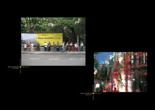
![In the same way, the visualisation of the pho- online communicational theories of Manuel collaboration, ranging from the theories pos- were an old tapestry which fits the space per-
tographic pieces against the map is rounded Castells to that return to the notion of citizen- tulated by Toni Negri, to others focusing on fectly, but under closer scrutiny seems to re-
off by another projection. Here, it is pos- ship, although it is now seen from the perspec- the market aspects of artworks, such as those veal a new reality: all of the elements become
sible to contemplate the photographs with tive of cyberspace, which, ultimately, is an uni- by the Swedish group Pirate Bay, as well as liquid, in a way which is reminiscent of those
a greater sense of immediacy, by means of a versalised meta-urban realm, as postulated by those which deal with the communicative and shallow water surfaces we see on Google Earth.
gallery which has sought to promote the idea Paul Virilio. poiesis elements of art, with classic exponents
of a “journey” when selecting the photographs such as Kant, Habermas and Danto and their At this point, terms such as azimuthal perspec-
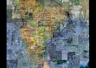
from the website. This combination of cartography and physi- concept of the “art world”. tive, urban planimetry, fragment and lability
cal representation of the images generated by begin to come together, given that the start-
“The very dynamics of users-photographers is also open to interven- However, beyond this dimension aimed at art ing point –as in Transurbancia– in this project
the exhibition creates a tion by the spectator-user, generating an ex- practices, Mapping Madrid has gone one step are satellite images and the processes which
sense of belonging to a change flow with which to understand the way further in the field of representation and the transform them, in this case, into a dense liq-
new media functions when combined with the idea of the construction of a map. This is due uid that dilutes not only the photo but also the
collective work, with the perception of a landscape which belongs to to the last part of the exhibition held at the historic centre of Madrid.
spectator-user creating us, given that we built it and we are the ones Gabinete de Exposiciones of the Palacio de
and activating the show, living in it. Altamira, which consists of three fragments “Density and fluidity
constructing a personal from the liquid city of Madrid and the piece
make it possible to
Some of these considerations were present Transurbancia, produced by Tete Álvarez,
and shared map in which at a series of lectures that took place last which is made up of a number of fragments of take the map as a
we can contemplate May, shortly before the inauguration of Map- cities which have the ability to build a new nar- cartographic basis from
different views of Madrid ping Madrid, entitled The Hybrid City, which rative on the map and on global reality.
which to initiate an
and PHotoEspaña” brought together several experts, led by José
exploration of the city,
Luis de Vicente, to reflect on “urban visualisa- The connection between place and photog-
The result is as expected: the very dynamics of tion and collaborative mapping”. As de Vicen- raphy is a recurring element in the work by an itinerary in which
the exhibition creates a sense of belonging to te points out, “we have seen the emergence of
a collective work, with the spectator-user cre- the real-time city, where citizens modify their
Tete Álvarez, as can be seen in pieces such
as Confines [Borders] or Desterritorios [Un-
the act of getting lost
ating and activating the show, constructing behaviour patterns as they go, and where the territories]. In this case, the pieces shown becomes a new way of
a personal and shared map in which we can function and meaning of places are constant- under the generic title of Ciudades líquidas. returning to
contemplate different views of Madrid and ly being reconfigured”. He could almost be
PHotoEspaña, which are generally far from speaking about the exhibition we are examin-
Madrid [Liquid Cities. Madrid] lend the map
a dimension which envelops the viewer. This
the unknown”
the usual institutionalised images, displaying ing here, as some of the lecture contents were fragmenting and change in scale comes from According to Tete Álvarez, “Density and fluid-
a very attractive sense of freshness. in fact collaborative mapping (the subjective a Madrid street map from the 1950s, which can ity make it possible to take the map as a carto-
city represented by its citizens) and gover- be seen in its entirety on the top left corner of
graphic basis from which to initiate an explora-
In this way, the show interweaves concepts nance 2.0 (collaborative democracy and digi- Transurbancia, on display in the same room. tion of the city, an itinerary in which the act of
such as the city, the map and the gaze, an ap- tal technologies). getting lost becomes a new way of returning to
proach whose significance can be observed The first outstanding element of these works the unknown”. However, this metamorphosis of
throughout history, and which continues to We could undoubtedly obtain many conclu- is their majesty, which, however, is somewhat the map into something liquid is directly linked
be highly relevant today, as proven by a large sions from this with regard to the current familiar. The contours of the maps are still to the diagnoses of our time, like that metaphor
part of current theoretical practices, from the political systems and the need for citizen recognisable and cover the walls as if they of the contemporary world popularised by Zyg-
42 Mapping Madrid · IED Madrid & PHE09 Mapping Madrid · IED Madrid & PHE09 43](https://image.slidesharecdn.com/2347886/85/CATALOGO-DE-MAPPING-MADRID-22-320.jpg)


El documento describe una exposición en el IED Madrid titulada "Mapping Madrid" que forma parte de la feria de fotografía PhotoEspaña. La exposición presenta mapas subjetivos de Madrid creados por estudiantes y profesores del IED a través de fotografías. El objetivo era explorar formas alternativas de representar una ciudad y ofrecer perspectivas diferentes sobre ella.


