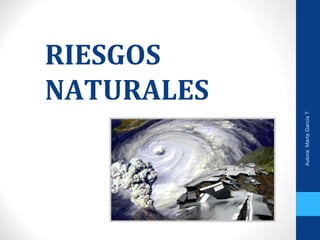
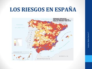
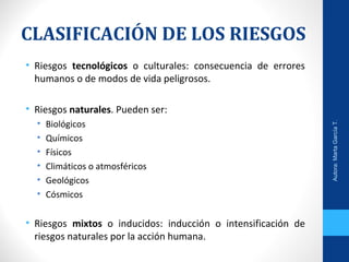
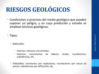
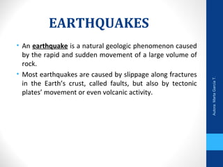
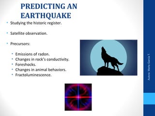
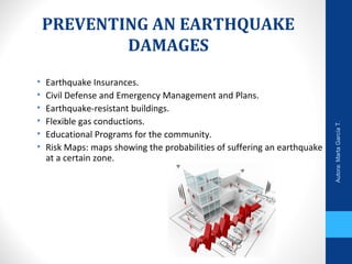
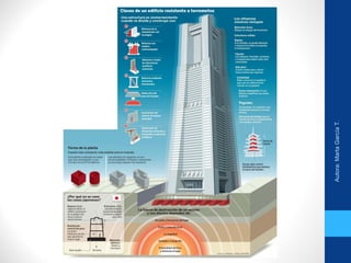
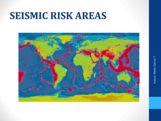
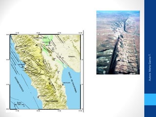
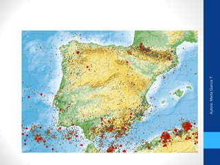
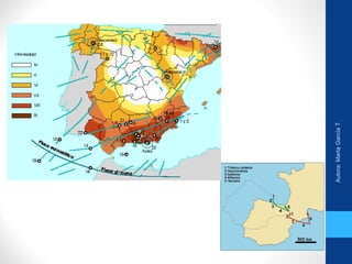
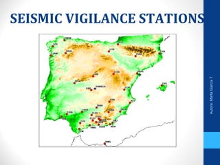
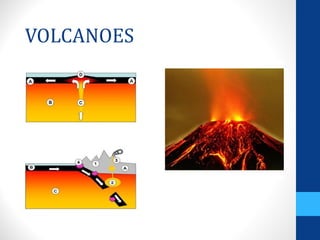
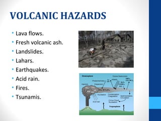
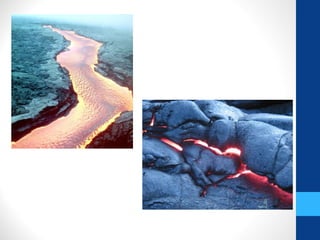
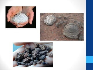
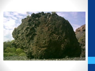
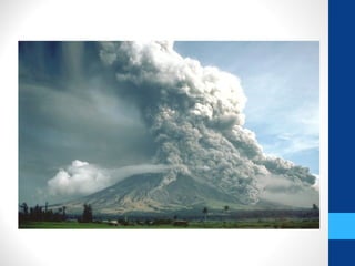
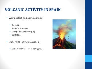
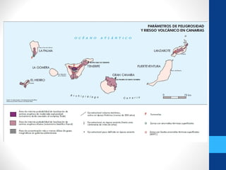
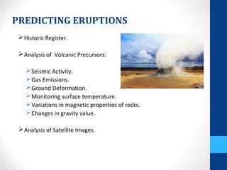
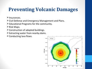
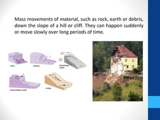
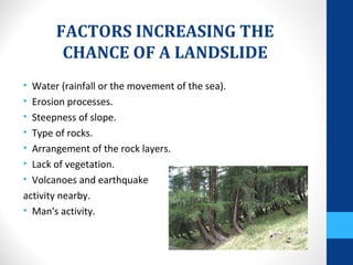
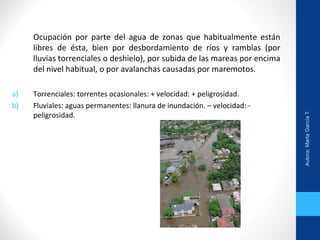
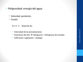
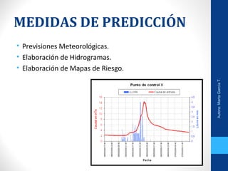
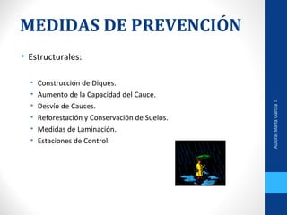
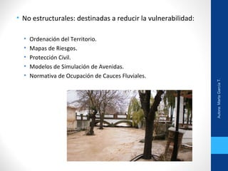
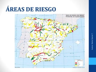
RIESGOS
NATURALES
Autora:MartaGarcíaT.
Para comenzar pensando….
• ¿Qué entiendes por riesgo?
• Enumera todos los riesgos que conozcas.
• Intenta clasificar los riesgos anteriores en naturales y
artificiales.
• Diferencia riesgo de impacto.
• Ahora en estas cuatro categorías: geológicos, meteorológicos,
hidrológicos y biológicos.
• ¿De qué depende que haya más o menos víctimas en un
riesgo natural?
• ¿Qué riesgos nos afectan en nuestra zona?
• Diferencia prevención de predicción.
• ¿Qué catástrofes asociadas a riesgos recuerdas?
Autora:MartaGarcíaT.
RIESGO
• Condición o proceso que pueda causar heridas, enfermedades,
pérdidas económicas, o daños al medio ambiente.
• Factores del riesgo: R = P x E x V
• Peligrosidad.
• Exposición.
• Vulnerabilidad.
• Predicción, Prevención y Corrección:
• Medidas Estructurales y No Estructurales.
Autora:MartaGarcíaT.
• Período de retorno es el tiempo esperado o tiempo medio
entre dos sucesos improbables y con posibles efectos
catastróficos.
Autora:MartaGarcíaT.
LOS RIESGOS EN ESPAÑA
Autora:MartaGarcíaT.
CLASIFICACIÓN DE LOS RIESGOS
• Riesgos tecnológicos o culturales: consecuencia de errores
humanos o de modos de vida peligrosos.
• Riesgos naturales. Pueden ser:
• Biológicos
• Químicos
• Físicos
• Climáticos o atmosféricos
• Geológicos
• Cósmicos
• Riesgos mixtos o inducidos: inducción o intensificación de
riesgos naturales por la acción humana.
Autora:MartaGarcíaT.
RIESGOS GEOLÓGICOS
• Condiciones o procesos del medio geológico que pueden
suponer un peligro, y en cuya predicción y estudio se
emplean técnicas geológicas.
• Tipos:
• Naturales:
• Internos: volcanes y terremotos.
• Externos: movimientos de laderas, aludes, inundaciones,
subsidencias, etc.
• Inducidos: terremotos por explosiones, inundaciones por rotura de
presas, subsidencias por edificación, etc.
Autora:MartaGarcíaT.
SEISMIC HAZARDS
Autora:MartaGarcíaT.
EARTHQUAKES
• An earthquake is a natural geologic phenomenon caused
by the rapid and sudden movement of a large volume of
rock.
• Most earthquakes are caused by slippage along fractures
in the Earth’s crust, called faults, but also by tectonic
plates’ movement or even volcanic activity.
Autora:MartaGarcíaT.
The place along the fault surface where slippage begins is the
focus or hypocenter.
Located at the surface directly above the focus is the epicenter.
During large earthquakes, a massive amount of energy is released
which travels in all directions in the form of seismic waves.
http://www.suu.edu/faculty/colberg/Hazards/Earthquakes/31_surface_waves_earthquakes/31.html
Autora:MartaGarcíaT.
• Seismographs have a mass freely suspended from a
support that is securely attached to the bedrock. When
vibrations from an earthquake reach the instrument, the
inertia of the mass keeps it relatively stationary while
bedrock and support move.
Autora:MartaGarcíaT.
Measuring Earthquakes’ Size
Intensity: a measure of the degree of earthquake shaking
at a given locale based on observed damage.
Mercalli Escale: XII Grades.
Magnitude: the amount of energy released at an
earthquake’s source.
Richter Escale: 1 - 10. Logaritmic.
http://elearning.niu.edu/simulations/images/S_portfolio/Mercalli/Mercalli_Sc
ale.swf
Autora:MartaGarcíaT.
DESTRUCTION FROM SEISMIC
VIBRATIONS
• Intensity.
• Duration of the ground shaking.
• Cohesion and strength of the material.
• Design of the structure.
• How deep the hypocenter is.
• How far the epicenter is.
Autora:MartaGarcíaT.
EARTHQUAKES HAZARDS
- Liquefaction.
- Seiches.
- Tsunamis.
- Landslides.
Autora:MartaGarcíaT.
PREDICTING AN
EARTHQUAKE
• Studying the historic register.
• Satellite observation.
• Precursors:
• Emissions of radon.
• Changes in rock’s conductivity.
• Foreshocks.
• Changes in animal behaviors.
• Fractoluminescence.
Autora:MartaGarcíaT.
PREVENTING AN EARTHQUAKE
DAMAGES
• Earthquake Insurances.
• Civil Defense and Emergency Management and Plans.
• Earthquake-resistant buildings.
• Flexible gas conductions.
• Educational Programs for the community.
• Risk Maps: maps showing the probabilities of suffering an earthquake
at a certain zone.
Autora:MartaGarcíaT.
SEISMIC RISK AREAS
Autora:MartaGarcíaT.
SEISMIC VIGILANCE STATIONS
Autora:MartaGarcíaT.
VOLCANIC HAZARDS
VOLCANOES
VOLCANIC HAZARDS
• Lava flows.
• Fresh volcanic ash.
• Landslides.
• Lahars.
• Earthquakes.
• Acid rain.
• Fires.
• Tsunamis.
VOLCANIC ACTIVITY IN SPAIN
• Without Risk (extinct volcanoes):
• Gerona.
• Almería – Murcia.
• Campo de Calatrava (CR)
• Castellón.
• Under Risk (active volcanoes):
• Canary Islands: Teide, Teneguía.
PREDICTING ERUPTIONS
Historic Register.
Analysis of Volcanic Precursors:
Seismic Activity.
Gas Emissions.
Ground Deformation.
Monitoring surface temperature.
Variations in magnetic properties of rocks.
Changes in gravity value.
Analysis of Satellite Images.
Preventing Volcanic Damages
Insurances.
Civil Defense and Emergency Management and Plans.
Educational Programs for the community.
Risk Maps.
Construction of adapted buildings.
Extracting water from nearby dams.
Conducting lava flows.
LANDSLIDES
Mass movements of material, such as rock, earth or debris,
down the slope of a hill or cliff. They can happen suddenly
or move slowly over long periods of time.
FACTORS INCREASING THE
CHANCE OF A LANDSLIDE
• Water (rainfall or the movement of the sea).
• Erosion processes.
• Steepness of slope.
• Type of rocks.
• Arrangement of the rock layers.
• Lack of vegetation.
• Volcanoes and earthquake
activity nearby.
• Man's activity.
INUNDACIONES
Autora:MartaGarcíaT.
Ocupación por parte del agua de zonas que habitualmente están
libres de ésta, bien por desbordamiento de ríos y ramblas (por
lluvias torrenciales o deshielo), por subida de las mareas por encima
del nivel habitual, o por avalanchas causadas por maremotos.
a) Torrenciales: torrentes ocasionales: + velocidad: + peligrosidad.
b) Fluviales: aguas permanentes: llanura de inundación. – velocidad: -
peligrosidad.
Autora:MartaGarcíaT.
• Peligrosidad: energía del agua:
• Velocidad: pendiente.
• Caudal:
Q = A ∙ V Depende de:
• Intensidad de las precipitaciones.
• Estaciones del año  hidrograma – hidrograma de crecidas.
• Infiltración: vegetación – litología.
Autora:MartaGarcíaT.
MEDIDAS DE PREDICCIÓN
• Previsiones Meteorológicas.
• Elaboración de Hidrogramas.
• Elaboración de Mapas de Riesgo.
Autora:MartaGarcíaT.
MEDIDAS DE PREVENCIÓN
• Estructurales:
• Construcción de Diques.
• Aumento de la Capacidad del Cauce.
• Desvío de Cauces.
• Reforestación y Conservación de Suelos.
• Medidas de Laminación.
• Estaciones de Control.
Autora:MartaGarcíaT.
• No estructurales: destinadas a reducir la vulnerabilidad:
• Ordenación del Territorio.
• Mapas de Riesgos.
• Protección Civil.
• Modelos de Simulación de Avenidas.
• Normativa de Ocupación de Cauces Fluviales.
Autora:MartaGarcíaT.
ÁREAS DE RIESGO
Autora:MartaGarcíaT.
AREAS DE RIESGO
• Zona Norte:
• Valles estrechos.
• Poblaciones muy cercanas al cauce.
• Lluvias intensas.
• Pirineos:
• Torrentes.
• Lluvias intensas.
• Levante:
• Gota Fría.
• Suelos muy erosionados.
• Desembocaduras no respetadas.
• Cauces descuidados o construidos.
• Cuencas de los grandes ríos.
http://www.elmundo.es/elmundo/2003/graficos/oct/s3/g
ota_fria.html
http://www.consumer.es/web/es/medio_ambiente/natur
aleza/2004/08/12/140158.php
Autora:MartaGarcíaT.

Riesgos

  • 1.
  • 2.
    Para comenzar pensando…. •¿Qué entiendes por riesgo? • Enumera todos los riesgos que conozcas. • Intenta clasificar los riesgos anteriores en naturales y artificiales. • Diferencia riesgo de impacto. • Ahora en estas cuatro categorías: geológicos, meteorológicos, hidrológicos y biológicos. • ¿De qué depende que haya más o menos víctimas en un riesgo natural? • ¿Qué riesgos nos afectan en nuestra zona? • Diferencia prevención de predicción. • ¿Qué catástrofes asociadas a riesgos recuerdas? Autora:MartaGarcíaT.
  • 3.
  • 4.
    RIESGO • Condición oproceso que pueda causar heridas, enfermedades, pérdidas económicas, o daños al medio ambiente. • Factores del riesgo: R = P x E x V • Peligrosidad. • Exposición. • Vulnerabilidad. • Predicción, Prevención y Corrección: • Medidas Estructurales y No Estructurales. Autora:MartaGarcíaT.
  • 5.
    • Período deretorno es el tiempo esperado o tiempo medio entre dos sucesos improbables y con posibles efectos catastróficos. Autora:MartaGarcíaT.
  • 6.
    LOS RIESGOS ENESPAÑA Autora:MartaGarcíaT.
  • 7.
    CLASIFICACIÓN DE LOSRIESGOS • Riesgos tecnológicos o culturales: consecuencia de errores humanos o de modos de vida peligrosos. • Riesgos naturales. Pueden ser: • Biológicos • Químicos • Físicos • Climáticos o atmosféricos • Geológicos • Cósmicos • Riesgos mixtos o inducidos: inducción o intensificación de riesgos naturales por la acción humana. Autora:MartaGarcíaT.
  • 8.
    RIESGOS GEOLÓGICOS • Condicioneso procesos del medio geológico que pueden suponer un peligro, y en cuya predicción y estudio se emplean técnicas geológicas. • Tipos: • Naturales: • Internos: volcanes y terremotos. • Externos: movimientos de laderas, aludes, inundaciones, subsidencias, etc. • Inducidos: terremotos por explosiones, inundaciones por rotura de presas, subsidencias por edificación, etc. Autora:MartaGarcíaT.
  • 9.
  • 10.
    EARTHQUAKES • An earthquakeis a natural geologic phenomenon caused by the rapid and sudden movement of a large volume of rock. • Most earthquakes are caused by slippage along fractures in the Earth’s crust, called faults, but also by tectonic plates’ movement or even volcanic activity. Autora:MartaGarcíaT.
  • 11.
  • 12.
    The place alongthe fault surface where slippage begins is the focus or hypocenter. Located at the surface directly above the focus is the epicenter. During large earthquakes, a massive amount of energy is released which travels in all directions in the form of seismic waves. http://www.suu.edu/faculty/colberg/Hazards/Earthquakes/31_surface_waves_earthquakes/31.html Autora:MartaGarcíaT.
  • 13.
    • Seismographs havea mass freely suspended from a support that is securely attached to the bedrock. When vibrations from an earthquake reach the instrument, the inertia of the mass keeps it relatively stationary while bedrock and support move. Autora:MartaGarcíaT.
  • 14.
    Measuring Earthquakes’ Size Intensity:a measure of the degree of earthquake shaking at a given locale based on observed damage. Mercalli Escale: XII Grades. Magnitude: the amount of energy released at an earthquake’s source. Richter Escale: 1 - 10. Logaritmic. http://elearning.niu.edu/simulations/images/S_portfolio/Mercalli/Mercalli_Sc ale.swf Autora:MartaGarcíaT.
  • 15.
  • 16.
    DESTRUCTION FROM SEISMIC VIBRATIONS •Intensity. • Duration of the ground shaking. • Cohesion and strength of the material. • Design of the structure. • How deep the hypocenter is. • How far the epicenter is. Autora:MartaGarcíaT.
  • 17.
    EARTHQUAKES HAZARDS - Liquefaction. -Seiches. - Tsunamis. - Landslides. Autora:MartaGarcíaT.
  • 18.
    PREDICTING AN EARTHQUAKE • Studyingthe historic register. • Satellite observation. • Precursors: • Emissions of radon. • Changes in rock’s conductivity. • Foreshocks. • Changes in animal behaviors. • Fractoluminescence. Autora:MartaGarcíaT.
  • 19.
    PREVENTING AN EARTHQUAKE DAMAGES •Earthquake Insurances. • Civil Defense and Emergency Management and Plans. • Earthquake-resistant buildings. • Flexible gas conductions. • Educational Programs for the community. • Risk Maps: maps showing the probabilities of suffering an earthquake at a certain zone. Autora:MartaGarcíaT.
  • 20.
  • 21.
  • 22.
  • 23.
  • 24.
  • 25.
  • 26.
  • 27.
  • 28.
    VOLCANIC HAZARDS • Lavaflows. • Fresh volcanic ash. • Landslides. • Lahars. • Earthquakes. • Acid rain. • Fires. • Tsunamis.
  • 33.
    VOLCANIC ACTIVITY INSPAIN • Without Risk (extinct volcanoes): • Gerona. • Almería – Murcia. • Campo de Calatrava (CR) • Castellón. • Under Risk (active volcanoes): • Canary Islands: Teide, Teneguía.
  • 35.
    PREDICTING ERUPTIONS Historic Register. Analysisof Volcanic Precursors: Seismic Activity. Gas Emissions. Ground Deformation. Monitoring surface temperature. Variations in magnetic properties of rocks. Changes in gravity value. Analysis of Satellite Images.
  • 36.
    Preventing Volcanic Damages Insurances. CivilDefense and Emergency Management and Plans. Educational Programs for the community. Risk Maps. Construction of adapted buildings. Extracting water from nearby dams. Conducting lava flows.
  • 37.
  • 38.
    Mass movements ofmaterial, such as rock, earth or debris, down the slope of a hill or cliff. They can happen suddenly or move slowly over long periods of time.
  • 39.
    FACTORS INCREASING THE CHANCEOF A LANDSLIDE • Water (rainfall or the movement of the sea). • Erosion processes. • Steepness of slope. • Type of rocks. • Arrangement of the rock layers. • Lack of vegetation. • Volcanoes and earthquake activity nearby. • Man's activity.
  • 40.
  • 41.
    Ocupación por partedel agua de zonas que habitualmente están libres de ésta, bien por desbordamiento de ríos y ramblas (por lluvias torrenciales o deshielo), por subida de las mareas por encima del nivel habitual, o por avalanchas causadas por maremotos. a) Torrenciales: torrentes ocasionales: + velocidad: + peligrosidad. b) Fluviales: aguas permanentes: llanura de inundación. – velocidad: - peligrosidad. Autora:MartaGarcíaT.
  • 42.
    • Peligrosidad: energíadel agua: • Velocidad: pendiente. • Caudal: Q = A ∙ V Depende de: • Intensidad de las precipitaciones. • Estaciones del año  hidrograma – hidrograma de crecidas. • Infiltración: vegetación – litología. Autora:MartaGarcíaT.
  • 43.
    MEDIDAS DE PREDICCIÓN •Previsiones Meteorológicas. • Elaboración de Hidrogramas. • Elaboración de Mapas de Riesgo. Autora:MartaGarcíaT.
  • 44.
    MEDIDAS DE PREVENCIÓN •Estructurales: • Construcción de Diques. • Aumento de la Capacidad del Cauce. • Desvío de Cauces. • Reforestación y Conservación de Suelos. • Medidas de Laminación. • Estaciones de Control. Autora:MartaGarcíaT.
  • 45.
    • No estructurales:destinadas a reducir la vulnerabilidad: • Ordenación del Territorio. • Mapas de Riesgos. • Protección Civil. • Modelos de Simulación de Avenidas. • Normativa de Ocupación de Cauces Fluviales. Autora:MartaGarcíaT.
  • 46.
  • 47.
    AREAS DE RIESGO •Zona Norte: • Valles estrechos. • Poblaciones muy cercanas al cauce. • Lluvias intensas. • Pirineos: • Torrentes. • Lluvias intensas. • Levante: • Gota Fría. • Suelos muy erosionados. • Desembocaduras no respetadas. • Cauces descuidados o construidos. • Cuencas de los grandes ríos. http://www.elmundo.es/elmundo/2003/graficos/oct/s3/g ota_fria.html http://www.consumer.es/web/es/medio_ambiente/natur aleza/2004/08/12/140158.php Autora:MartaGarcíaT.
  • 48.
  • 49.